


All Time Popular > Page 3692
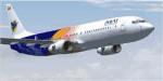
FSX Myanmar Airways International Boeing 737-800 New Flag Textures
(Category: FSX > Civil Jets)
3.19Mb (649 downloads)
Textures for the default FSX B737_800 in older Myanmar Airways International Colors (the most beautiful ever). With new Myanmar (Burma) flag, that is used in the country since October 2010.
Posted Aug 21, 2012 16:04 by HOUSE-RP, Robby Pauletto
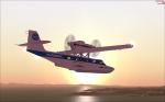
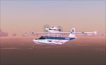
Dornier Seastar Pan Am Textures
(Category: FSX > Props)
2.81Mb (649 downloads)
PanAm "what if" livery applied to the Premier Aircraft Design Dornier Seastar. Make sure to read the readme! Named after a friend of mine who gave the green light for this project. By Josef A. Kunzlar of FSXTipline
Required files:
required file
Posted Sep 22, 2011 04:44 by Josef of FSXTipline.blogspot.com
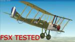
FSX Royal SB2c Hellenic Navy Air Service IKARIA Textures
(Category: FSX > Vintage)
1.11Mb (649 downloads)
This is the Hellenic Naval Air Service (NAYTIKH AEROPORIKH YPHRESIA N.A.Y.)Royal SB2c #8414 (IKARIA) that served the Hellenic Royal Navy (VASILIKO NAYTIKO) from 1919-1922. Early reconisence aircraft that was in action during WW1 In The Asia Minor Campaign as a Recognizer. It also had a trainer role for the Hellenic Navy.
You will need the Edward Cooks Freeware model rafbe2v2 zip for this that can be found at Simviation 2004 Vintage page.
The model has moving parts full VC and 2D Panel and gauges
I have tested the model in FSX Acceleration Only and the textures are DX5
if you want to use them in 2004 you have to chance them into BMP,s
The Repaint on the Hellenic colors was done by YIANNIS KATEHIS TSETSAS
Required files:
required file
Posted Jul 19, 2011 21:36 by YIANNIS KATEHIS TSETSAS
CFS2
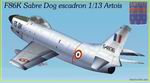
F86K Sabre Dog ECTT 1/13 Artois (French Air Force)
(Category: CFS2 > Post WW2 Aircraft)
1.05Mb (649 downloads)
CFS2
F86K Sabre Dog ECTT 1/13 Artois (French Air Force).
Original model by Angelo Moneta. 1.1 MB
Posted Jun 10, 2008 11:30 by archive
CFS
2 SBD Dauntless Repaint
(Category: CFS2 > Aircraft)
0.44Mb (649 downloads)
CFS
2 SBD Dauntless Repaint -
New Stock Replacement SBD Texture, Second in series , has bullet damage,
weathering , and a panel inclosed , Adds to the realism Of CFS2, Must
have the AI patch to be able to fly them ,Panel was provided by Dan
Griffin. 449K
Posted Sep 19, 2007 08:52 by archive
Damage
Profile Editing Notes
(Category: CFS1 > Misc)
0.01Mb (649 downloads)
Damage
Profile Editing Notes. Good document describing how to edit
your .dp files
Posted Jun 10, 2008 11:32 by archive
FS98 ADVENTURE - CIRCUIT TRAINING DOWNUNDER
(Category: FS98 > Adventures)
0.37Mb (649 downloads)
FS98
ADVENTURE - CIRCUIT TRAINING DOWNUNDER FS98 adventure with
custom made ATC sound files taking you on a short circuit training
flight around Sydney's Kingsford Smith International Airport.
Designed for a large jet. Wilco van Dejil's GPWS98 is the core
of the adventure. Modified by Fermin Fernandez.. File size 385234
Posted Jun 23, 2008 14:19 by archive
FS2004
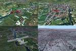
Caransebes Airport, Romania LRCS-Photo.Real.
(Category: FS2004 > Scenery)
5.65Mb (649 downloads)
FS2004
Caransebes Airport, Romania LRCS-Photo.Real. The
town of Caransebes is situated in South-West of Romania, having
the coordinates of 45° 25'lat N and 22° 13'long E. It is the
second largest town in the Caras-Severin County and has a strategic
geographical position. 5.8MB
Posted Jun 23, 2008 14:24 by archive
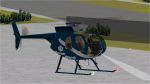
MD500
SKI- COPTER
(Category: FS2000 > Helicopters)
3.03Mb (649 downloads)
MD500
SKI- COPTER with panel and sounds nite-lite effects and
moving parts, working Landing-lite beam. By : Tom Hutson. 3.1MB
Posted Jun 23, 2008 14:37 by archive
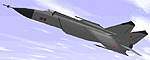
Mig
25 Foxbat
(Category: FS98 > Military)
0.04Mb (649 downloads)
FS98 Mig
25 Foxbat. File size 26880
Posted Jun 23, 2008 14:22 by archive