


All Time Popular > Page 4149
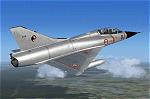
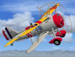
Restauravia Mirage IIIB - CIFAS 328, 1978 Textures
(Category: FSX > Military)
5.65Mb (486 downloads)
Textures for use with the Mirage IIIB by Restauravia. They
represent a Mirage IIIB assigned to the CIFAS 328 at Bordeaux-Merignac in the Spring of 1978. Created using paintkit by Philippe Penot. Repaint by Frank Safranek.
Restauravia Mirage IIIB (external site)
Posted May 18, 2013 01:16 by Frank Safranek
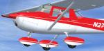
Cessna 152 Red and White Textures
(Category: FSX > Props)
2.04Mb (486 downloads)
FSX Cessna 152 Rancho JEN repaint textures
for the fictional N2746W, a red on white 152
for the Rancho JEN Cessna 150,
which you must have previously installed in FSX.
I use the version updated for FSX by Mark Rooks.
Textures are your choice of DXT3 1024 pixels for
better frame rates, or 32 bit 2048 pixels for better
clarity and higher definition, both with no mips.
Install one or the other, or install both at once
if you wish. Easy installation. Repaint by Tom Tiedman.
Required files:
required file
Posted Oct 13, 2011 04:56 by Tom Tiedman
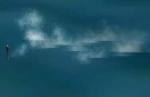
USS Gato Submerged
(Category: CFS2 > Misc)
0.41Mb (486 downloads)
This is the totally submerged version of the TR_VN_Gato submarine. She is running at periscope depth. All you will see above the surface is the periscope and the small wake it creates. However, the entire submarine is there and can be damaged/destroyed with standard weapons other than guns. The periscope does show on 'radar'.
Posted Oct 9, 2010 16:18 by Tom Sanford, Tango_Romeo
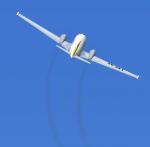
FSX USS Macon Textures for F9C Sparrowhawk
(Category: FSX > Vintage)
0.23Mb (486 downloads)
This file includes textures for the F9C Sparrowhawks assigned to the ZRS-5 USS Macon airship. A new Aircraft .cfg file is included. This is a repaint only, you need 1f9c2.zip for the rest of the project.
Required files:
required file
Posted Oct 6, 2010 15:47 by Paul Clawson
CFS2
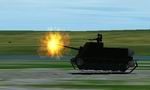
Soviet 85mm self propelled gun
(Category: CFS2 > Misc)
1.10Mb (486 downloads)
CFS2
Soviet 85mm self propelled gun
. Armed with 85mm gun and 1 50 cal machinegun.manualy extract SU85
and 85mm files and put in your CFS2 aircraft folder.Put fx_rcktexst_l
in your CFS2 Effects folder. Back up your original fx_rcktexst_l file.
SU85 and 85mm projectile were made by me Gerald Goldsmith. 1.1MB
Posted Jun 10, 2008 11:09 by archive
PT
Boat Conversion for CFS2.
(Category: CFS2 > Misc)
0.06Mb (486 downloads)
PT
Boat Conversion for CFS2.
Aircraft folder 'Gunboat' and contents- the Stock CFS2 PT boat converted
for player use.. by Mark Walsh. 62K
Posted Jun 10, 2008 11:09 by archive
CFSII
Test Range,
(Category: CFS2 > Scenery)
0.14Mb (486 downloads)
CFSII
Test Range, Ft Davis Texas> This will add a gun convergence
range, bombing range, and take off and landing distance markers for
determining takaeoff and landing distances. All distances are in feet.
Floating distance markers, barrage ballons, and a few fireant mounds
around the field. By Steve McClelland. 141K
Posted Jun 10, 2008 11:30 by archive
Four
historical missions for CFS1 consecrated to the Campaign of France,
german side,
(Category: CFS1 > Missions & Campaigns)
0.04Mb (486 downloads)
Four
historical missions for CFS1 consecrated to the Campaign of France,
german side,
by G.West. CF1All. 11/5/1940. Mission of the I/StG2 (Ju87B) against
french defenses at Sedan. CF2All. 21/5/1940. (Fictive) mission under
command of oberleutnant H. Philipp, against the plane of general Weygand,
on inspection tour (real) in the north of France. CF3All. 1/6/1940.
Escort mission of the He111 sent to Dunkirk to bomb the allied convoys
on their way to England. CF4All. 3/6/1940. Escort mission of the Do17z
sent for a bombing mission on Villacoublay airport, on the 3rd of
june, during ‘Paula Operation’. These missions need, besides CFS planes,
the following aircrafts, all to be found on Simviation and other sites
: Curtiss Hawk75a by B.Duffort et C.Johnson on CFS France (Specific
name : « BR Hawk 75A vichy ») Bloch 152C by B.Duffort et P.Didier
on Simviation(Specific name : « BR Bloch MB-152C ») Amiot 354 by H.
Devred on Maiquarante (Specific name : « Amiot 354-1 ») MS406 by J-M
Mermaz on CFS France (Specific name: « MS406 ») Warning : the aircraft
conceivers may have several models of the same planes, or may have
change the specific names of their planes (the names that appear in
the ‘Briefing of the mission’) : check that there are the same when
downloading. . Gérald West. 42K
Posted Jun 10, 2008 11:32 by archive
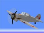
Polish
PZL P-50a Jastrzab (Hawk)
(Category: CFS1 > Aircraft)
0.46Mb (486 downloads)
Polish
PZL P-50a Jastrzab (Hawk) prototype fighter for CFS by Eric
of AOL . Features: -Fully functioning moving parts -Panel -Accurate
markings -Damage profile -Detailed virtual cockpit. 480K
Posted Jun 10, 2008 11:32 by archive
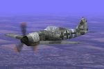
Focke-Wulf
Fw190A-8 "Viktor"
(Category: CFS1 > Aircraft)
0.20Mb (486 downloads)
Focke-Wulf
Fw190A-8 "Viktor" | Focke Wulf Fw 190 A-8/R-8, 8./JG 300,
Leutnant Viktor Heimann Finsterwalde/Germany December 1944. Repainted
by mrbomber. 203K
Posted Jun 10, 2008 11:32 by archive