


All Time Popular > Page 4289
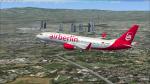
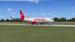
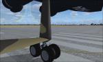
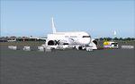
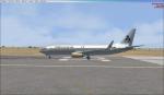
FSX Default Boeing 737-800 Air Berlin textures
(Category: FSX > Civil Jets)
8.07Mb (441 downloads)
Air Berlin textures for the default FSX Boeing 737-800. Have fun with the livery.
Posted Jun 5, 2020 09:04 by Planespotter Nordhessen-YT
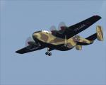
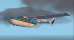
External views for the Blackburn Beverley
(Category: FSX > Props)
0.34Mb (441 downloads)
Created on a wide screen monitor, copy content into your aircraft.cfg!
Wish all a peaceful christmas and a happy new year!
Required files:
required file
Posted Dec 20, 2016 13:48 by Andiroto

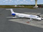
Delta CSeries 100
(Category: FS2004 > Civil Jets)
2.90Mb (441 downloads)
FS2004 Delta CSeries 100 V4. This version 4, features more improved and detailed aircraft model and textures , including CamSim's own static displays and Animated Ground Servicing (AGS).
Model design and paint by Camil Valiquette.
Posted Apr 29, 2016 08:06 by camil valliquette

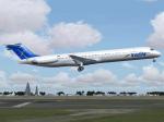
FS2004 Venezolana McDonnell-Douglas MD-82 YV191T (Updated) Textures
(Category: FS2004 > Civil Jets)
1.09Mb (441 downloads)
McDonnell-Douglas MD-82, cn 49392, ex-Spirit Airlines registration N822NK,
later Aeropostal (Alas de Venezuela), registration YV253T, now wears the
colors of Venezolana - Rutas Aereas de Venezuela (RAV,S.A.), registration
YV191T. Fully reworked textures, tail and wings. Updated textures only for SGA's latest Douglas MD-80 series release(sga80.zip), by Erick Cantu &
Frank Idone package.
By Juan Ernesto Oropeza.
Required files:
required file
Posted Sep 6, 2015 22:36 by Juan Ernesto Oropeza
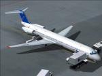
FS2004 McDonnell-Douglas MD-82 Insel Air Textures
(Category: FS2004 > Civil Jets)
1.08Mb (441 downloads)
McDonnell-Douglas MD-82, cn 49434/1446, registration PJ-MDC. Textures
only for SGA's latest Douglas MD-80 series release, (sga80.zip), by Erick
Cantu & Frank Idone package. Fully reworked textures, tail and wings.
By Juan Ernesto Oropeza.
Required files:
required file
Posted Aug 31, 2015 14:45 by Juan ErnestoOropeza
FSX Camsim Airbus A350-1000 v4
(Category: FS Design > Aircraft Paintkits)
9.30Mb (441 downloads)
FSX Paint Kit Airbus A350-1000 v4. This CamSim version 4 features more Animated Ground Servicing (AGS),
featuring trucks hooking and unhooking trailers and static displays. Tilted main landing gear bogies updated.
Model design and paint by Camil Valiquette.
Posted Dec 19, 2013 05:10 by Camil Valiquette
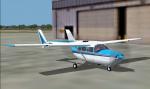
FS2004 Cessna Skymaster Alice Blue Textures
(Category: FS2004 > Props)
0.13Mb (441 downloads)
For use with the C337 by Mike Stone are these textures in a white with two tone blue scheme. These are the textures only, you need sc337.zip to use. Repaint by Don Brynelsen using Mike's paintkit.
Required files:
required file
Posted Jun 11, 2012 12:27 by Don Brynelsen
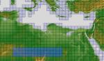
ASTER GDEMv2 30m mesh North Africa Pt2 incl Libya, Algeria
(Category: FSX > Terrain Mesh)
238.47Mb (441 downloads)
There are Eighteen (18) parts of this mesh to download as separate files.
ASTER GDEM Version 2 is a 30 metre definition DEM, its better than the version 1 data that ERSDAC, of Japan and NASA originally released, but it does have its limitations.
GDEM has been obtained from a satellite that uses stereoscopic infrared scanning cameras, this brings with it problems in the resultant data.....where it sees the tops of trees, buildings etc, as the ground terrain.
If you look at the jpg image with the terrain type errors shown as a graph, you will see that the only 'safe' terrain to use this data with - in FSX - is scrubland, or desert terrain.
Its hopeless in defining the terrain in places like Europe - with all the artificial structures, (buildings) and different types of woodland, so any mesh I create from this data won't include areas like that....it will be more desert type terrain, and scrubland.
I won't be doing Greenland because something about the ice around Greenland, (or any other land mass with ice) it creates false data.
It does give enough fine data to reveal railway lines, and some roads though.
This mesh has been made for FSX only.
Grateful thanks to ERSDAC, and NASA for making this data freely available to the public.
ASTER GDEM
Copyright (c) 2009 - 2011 Earth Remote Sensing Data Analysis Center (ERSDAC) All rights reserved.
ASTER GDEM is a product of METI and NASA.
Posted Apr 11, 2012 06:34 by Wayne Evans
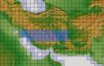
ASTER GDEMv2 30m mesh for Iran & West Caspian Sea States Pt5a
(Category: FSX > Terrain Mesh)
84.48Mb (441 downloads)
There are Fourteen (14) parts of this mesh to download as separate files.
ASTER GDEM Version 2 is a 30 metre definition DEM, its better than the version 1 data that ERSDAC, of Japan and NASA originally released, but it does have its limitations.
GDEM has been obtained from a satellite that uses stereoscopic infrared scanning cameras, this brings with it problems in the resultant data.....where it sees the tops of trees, buildings etc, as the ground terrain.
If you look at the jpg image with the terrain type errors shown as a graph, you will see that the only 'safe' terrain to use this data with - in FSX - is scrubland, or desert terrain.
Its hopeless in defining the terrain in places like Europe - with all the artificial structures, (buildings) and different types of woodland, so any mesh I create from this data won't include areas like that....it will be more desert type terrain, and scrubland.
I won't be doing Greenland because something about the ice around Greenland, (or any other land mass with ice) it creates false data.
It does give enough fine data to reveal railway lines, and some roads though.
This mesh has been made for FSX only.
Grateful thanks to ERSDAC, and NASA for making this data freely available to the public.
ASTER GDEM
Copyright (c) 2009 - 2011 Earth Remote Sensing Data Analysis Center (ERSDAC) All rights reserved.
ASTER GDEM is a product of METI and NASA.
Posted Mar 10, 2012 06:54 by Wayne Evans

Mexicana B737-800 1970s Livery Textures
(Category: FSX > Civil Jets)
6.47Mb (441 downloads)
FSX B737-800 Mexicana de Aviacion
1970s Livery. Textures for the default Boeing 737-800.
This texture is fictional since
Mexicana never had B737, but on
its golden years it was a great
Boeing B727, B757 and B767 operator
and I wish Mexicana had kept
using Boeing airplanes
By Sigfrido Munguia
Posted Jun 11, 2011 20:20 by Sigfrido Munguia