



All Time Popular > Page 4305

30m Australia mesh Northern Territory V2
(Category: FSX > Terrain Mesh)
278.66Mb (440 downloads)
G'day Cobbers,
This is version 2 of the 30m Australia mesh, file 4 Northern Territory.
This updated mesh contains no pink stuff and does not depress the sea.
It is renamed to ensure it is loaded in the correct order.
If one previously downloaded the 30m Australian mesh I released please replace it with this version.
Thanks and enjoy,
drunk
Posted Oct 13, 2014 03:23 by Brett Simtropolis


A2A Cessna 172 Slovakian OM-TNB Textures
(Category: FSX > Payware)
15.66Mb (440 downloads)
A2A Simulations C-172 Slovak OM-TNB textures.
Cessna 172 OM-TNB is owned by the Aero Club of Trencin in the Slovak Republic
Posted Aug 6, 2014 07:09 by archive
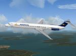
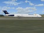
Flight1 Aeropostal McDonnell-Douglas MD-82 (YV134T) Textures
(Category: FS2004 > Payware)
2.59Mb (440 downloads)
McDonnell-Douglas MD-82, (cn 49394/1285), registration number YV134T, when it was in service with the Aeropostal-Alas de Venezuela fleet. Textures only for the Flight One Software CoolSky Super80 Douglas MD-80, (payware package). Flight
Dynamics by Jerry Beckwith, Aircraft Model & Texture by Terry Gaff. Look at
http://www.flight1.com/ for detailed info.
By Juan Ernesto Oropeza.
Posted Jun 20, 2012 03:26 by Juan Ernesto Oropeza


F_Giulli_Piaggio_P119
(Category: CFS2 > Aircraft)
5.58Mb (440 downloads)
The Piaggio P.119 was a cantilever monoplane, constructed completely of metal, with a conventional wide undercarriage. It had a forward-mounted cockpit, with the weapons mounted just behind the three-blade propeller. Air intakes for cooling were fitted under the nose. It had advanced construction for the time, with many removable panels for internal inspection. The number of components were reduced to a minimum, and also standardized, to make construction as easy as possible. No other Italian aircraft was so advanced in these details.
Posted May 21, 2011 16:34 by Pepe Rezende
KGSP International Airport, Greenville SC Update
(Category: FSX > Scenery)
0.84Mb (440 downloads)
KGSP International Airport, Greenville SC updated for FSX.
I took the default airport and made all jetways visible and can be called to the jet by pressing CNTRL-J. Also made all buildings visible and added a terminal.
Posted Oct 29, 2010 06:18 by Uploader

GZR_
Foggia Italy is the third in a series of CFS2 sceneries.
(Category: CFS2 > Scenery)
0.13Mb (440 downloads)
GZR_
Foggia Italy is the third in a series of CFS2 sceneries. These
show the Italian airfields during WW II. By April 1944, The USAAC
had a base at Foggia. Foggia shortened the range to Eastern Europe.
Missions included many attacks on Ploesti. Foggia was primarily a
bomber base. There is a lighted runway and refueling. Dual start can
be made from the ramp or runway. By Ric Charlebois-GZR Frenchy- Frenchy
335th. 135K
Posted Jun 10, 2008 11:30 by archive

CFS2
Damage profile for Jordan Moore's UH-1.
(Category: CFS2 > Post WW2 Aircraft)
0.00Mb (440 downloads)
CFS2
Damage profile for Jordan Moore's UH-1.
(many versions available - one example here
) Place the air and damage profile into Jordan Moore's helicopter
folder for the Huey to have guns and troops. Require's Nibbio's ground
troops. David Needham. 5K
Posted Jun 10, 2008 11:30 by archive
CFS1
Moon
(Category: CFS1 > Misc)
0.02Mb (440 downloads)
CFS1
Moon - the files required to put a moon in the original CFS.
Original idea by Chuck Dome, compiled by 'VM_Col_Shadow'. 17K
Posted Jun 10, 2008 11:09 by archive

CFS
Me_264-V1__ update Updated "Air" file
(Category: CFS1 > Aircraft)
0.01Mb (440 downloads)
CFS
Me_264-V1__ update Updated "Air" file for the Me_264-V1 fom
the Luft'46 series(above) . By CM Carlson. 8K
Posted Jun 10, 2008 11:32 by archive

U.S.
Nav Aids
(Category: FS2000 > Utilities)
0.12Mb (440 downloads)
U.S.
Nav Aids now includes Alaska, New York, Northern Pennsylvania,
Northern New Jersey, Central and Western Connecticut, Central
and Western Massachusetts and Vermont. U.S. Nav Aids was
made with Paint Shop Pro. Some of the maps require you Rotate
the map 90 degrees to print the full size map. The Cities
on the map are Navigation Points, but most of them have airports
as well. All maps display VOR's, NDB's and Elevations. All
maps are the latest versions with additional Nav Aids or corrections.
Created by Bob Baker. 121K
Posted Jun 23, 2008 14:34 by archive