


All Time Popular > Page 4357
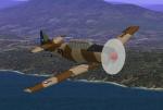
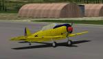
North American AT-6G Texan FACH
(Category: CFS1 > Aircraft)
0.92Mb (420 downloads)
FS98/CFS North American AT-6G Texan.
Chilean Air Force - Fuerza Aerea de Chile.
The North American AT-6 (late T-6) Texan was a single-engine advanced trainer aircraft used on this and other duties, in service in the Chilean Air Force between 1942 to 1978.
The North American AT-6G was used as advanced trainer (AT) during the years 40s-50s, flown by the chilean pilots, at Escuela de Aviaci¾n Capitßn Avalos. It was the third phase of the three phase training program for pilots. After basic training (BT) in the Vultee BT-13, the student pilot moved to the more complex AT-6G for advanced flight training.
Also, equipped with hardpoints was used for light attack, homebased at Grupo N║1, Iquique.
Converted to CFS1 and repainted in three different textures :
1) T-6G FACH # 269 on desert camouflage, Grupo N║1, Iquique.
2) T-6G FACH # 285 on "trainer yellow" color, preserved in the aeronautical museum at Cerrillos.
3) T-6G FACH # 297 all silver, Escuela de Aviaci¾n Capitßn Avalos.
I have included a panel, moving parts and damage profile for use with CFS1, with armament of two 0.30 machine guns (left leading edge and rear cockpit), rockets and bombs.
FS98 Aircraft Designer: Designer: Roger von Ahrens, Jr.
Panel, Chilean textures and DP for CFS: Edmundo Abad Dec. 2009
Also special thanks to Juan Concha & Roberto Ibarra, former FACH officers, by the great provided information for the development of this virtual model.
Posted Jan 14, 2010 20:01 by Edmundo Abad

FS2002/2004 Hilo Rose Texture fix
(Category: FS2004 > Props)
0.05Mb (420 downloads)
A redo of the fuselage textures for my Hilo Rose repaint that adds a needed anti glare panel. By Don Brynelsen
Posted Sep 27, 2009 14:19 by Don Brynelsen

CFS2/FS2004 Alphasim Republic P-47D , 4434/34, Portuguese Air Force, 1952 Textures
(Category: FS2004 > Payware)
1.97Mb (420 downloads)
CFS2/FS2004 Alphasim Republic P-47D Thunderbolt Bubble Top, 4434/34, Portuguese Air Force, 1952. This repaint is for the ALPHASIM model which can be found at: http://www.alphasim3.com/store/advanced_search_result.php?ke .. Repaint by Evan G. Butterbrodt (revev).
Posted Aug 18, 2008 04:52 by Evan G. Butterbrodt

FSX American Boeing 787-9 AGS-G4e.
(Category: FSX > Civil Jets)
12.70Mb (419 downloads)
FSX American Boeing 787-9 AGS-G4e.
Enhanced version of AGS-4th Generation ( Animated Ground Servicing )
and static display with new features and details, exclusively incorporate with the aircraft model.
High Definition Textures, saved in 32 bits.
Model design and paint by Camil Valiquette. ( CamSim )
Posted Apr 21, 2023 12:09 by Camil Valiquette
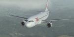
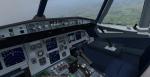
FSX/P3D Airbus A320-200 TUI operated by Smartlynx Malta package
(Category: FSX > Civil Jets)
85.56Mb (419 downloads)
FSX/P3D Airbus A320-200 TUI operated by Smartlynx Malta package. Smartlynx Malta is a new subsidiary of the Latvian airline Smartlynx and currently has 7 Airbus A320-200.
Model by Project Airbus. 2020 updated VC by Speedbird77 with built in FMC by Garret Smith. Includes A320 operation manual and checklist. Airbus sounds included. Textured, assembled for P3D v5.3 by Chris Evans. Should work in FSX and other P3D
Posted May 19, 2022 12:05 by chris evans
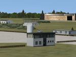
EDOV-06, Borstel Airpot, Germany
(Category: FSX > Scenery)
2.20Mb (419 downloads)
FSX scenery--Borstel airport EDOV near
Stendal in Sachsen Anhalt Germany.
Originally a WWII paratroops base, later
base of soviet jetfighters and helicopters,
but now in civilian use. By Thomas Erthner.
Posted Apr 26, 2020 12:40 by Thomas Erthner

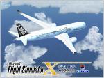
Airbus A350-900 V5L Ethiopian
(Category: FSX > Civil Jets)
5.36Mb (419 downloads)
FSX Ethiopian Airbus A350-900 V5L. This new update added landing light splash on the sides of the fuselage and more. 2d panel but no VC.
Model design and paint by Camil Valiquette.
Posted Dec 22, 2016 11:41 by Camil Valiquette
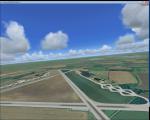
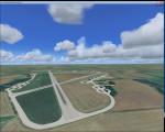
RAF Down Ampney, UK
(Category: FSX > Scenery)
1.94Mb (419 downloads)
RAF Down Ampney (ICAO X2DA) was a Royal Air Force station located 1.8 miles (2.9 km) north east of Cricklade, Wiltshire and 3 miles (4.8 km) south west of RAF Fairford, Gloucestershire.
The airfield operated during World War II from February 1944 until February 1947.
Down Ampney was part of a group of 3 airfields with RAF Broadwell and RAF Blakehill Farm dedicated to air transportation.
No. 48 Squadron RAF and No. 271 Squadron RAF flew Douglas Dakotas on major missions. On D-Day they dropped the main elements of the 3rd Parachute Brigade in Normandy as well as towing Airspeed Horsa gliders across the English Channel.
They were also active in Operation Market Garden (Arnhem) and the Rhine crossing.
Source: Wikipedia
Posted Apr 15, 2016 09:52 by Terry Boissel
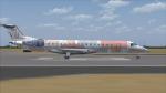
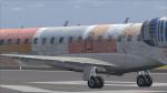
Embraer 145LU Guajira "Star Wars 7"
(Category: FS2004 > Civil Jets)
14.18Mb (419 downloads)
Embraer 145LU Guajira Airlines, Venezuela. Model by Project Opensky and textures by Yankyvictor. "Star Wars 7" Special scheme.
Posted May 7, 2015 21:58 by YANKYVICTOR
Airbus A350-900 XWB - FSX Splashscreen
(Category: Videos/Splashscreens > Splashscreens)
0.84Mb (419 downloads)
Airbus A350-900 XWB - FSX Splashscreen
- Copy the image " dlgsplash " in :
C:\Program ...\Microsoft Games\Microsoft Flight Simulator X\Uires
no error
Posted Aug 24, 2014 02:12 by juan30005