


All Time Popular > Page 4360
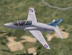
FS2002
original Repaint of the BAe Hawk 19sqn in the old low viz gray
paint special livery,based at RAF Valley.(textures only).
(Category: FS2002 > Military)
0.44Mb (419 downloads)
FS2002
original Repaint of the BAe Hawk 19sqn in the old low viz gray
paint special livery,based at RAF Valley.(textures only).You
will need the REDPACK1.ZIP (here)
for the
aircraft.Repaint by Dylan Roberts. 450K
Posted Jun 23, 2008 14:33 by archive
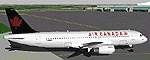
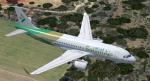
Air
Canada A320-211
(Category: FS98 > Civil Jets)
0.09Mb (419 downloads)
Air
Canada A320-211 Airbus File size 90754
Posted Jun 23, 2008 14:22 by archive
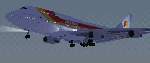
FS2000
Project Opensky BOEING B747-341 Iberia
(Category: FS2000 > Civil Jets)
1.28Mb (419 downloads)
FS2000
Project Opensky BOEING B747-341 Iberia A repaint of POSKY
747 in Iberia's colours. Features: 48-sided based Variable Sided
Fuelage (POSKY Original Technique) ThrustReverser,Moving flaperon's,spoileron's,aileron's,elevator's,rudder,
and fan blade's ,Tilting bogie's, gear bay's. (All highly detailed)night
lighting,flashing beacon's.Transparent cockpit windshield with
3-D pilot's. Designed By Mitsushi Yutaka , Hiroshi Igami Flight
Dynamics by Johan C Dees Tested by Project-Opensky Members Painted
by Manolo Machuca Medina. 1.3MB
Posted Jun 23, 2008 14:36 by archive
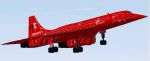
FS2000
Concorde repaint. Virgin Atlantic livery
(Category: FS2000 > Civil Jets)
0.04Mb (419 downloads)
FS2000
Concorde repaint. Virgin Atlantic livery. By Thomas Matthews.
46K
Posted Jun 23, 2008 14:36 by archive
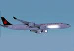
FS2000
Air Canada, Airbus A340-500
(Category: FS2000 > Civil Jets)
0.18Mb (419 downloads)
FS2000
Air Canada, Airbus A340-500 (ProMaxL2) Rollout of the first
Airbus A340-500 airplane set for Jan.04,2001 The A340-500 is
222 ft 10 in in overall length, compare with the 208 ft 10 in
of the A340-300, with a maximum range of 8500nm with 313 pax.
ProMaxL2, features all the moving parts and night textures of
the ProMaxLT, plus new textures showing passenger windows reflecting
on the wings at night and and redesign flaps. Model design and
paint by: Camil Valiquette. 186K
Posted Jun 23, 2008 14:36 by archive
FSX/P3D Airbus A320NEO SalamAir package
(Category: FSX > Civil Jets)
118.69Mb (418 downloads)
FSX/P3D Airbus A320-251N (Neo) SalamAir package. SalamAir is an Oman low cost airline based at Muscat International Airport. Currenly SalamAir have 6 Airbus A320-251N flying to destinations around the Middle East and Asia.
This is the standard Project Airbus A320 painted to resemble a N(neo) version with window and door placements.
Model by Project Airbus with NEO engine mod by Bret Herman. Updated VC by Speedbird77 with built in FMC by Garret Smith. Includes A320 operation manual and checklist. CFM NEO sounds included. Textured, assembled for P3D v5.4 by Chris Evans. Should work in FSX and other P3D
Posted Mar 22, 2024 10:21 by chris evans
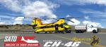
FSX/P3D Virtavia CH-46 Sky Aviation Texture Pack
(Category: FSX > Helicopters)
7.69Mb (418 downloads)
This pack represents ships N461WY and N462WY flown by Sky Aviation of Wyoming in aerial firefighting operations. This repaint pack is specifically for Virtavia's recently released freeware CH-46 Sea Knight. Textures have been increased to 4k as well. Repaints by Nicholas Mitchell "Scorch00"
Required files:
required file
Posted May 6, 2023 15:33 by Nicholas Mitchell
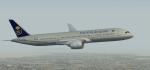
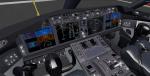
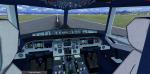
FSX/P3D /P3D Boeing 787-9 Saudia package
(Category: FSX > Civil Jets)
78.73Mb (418 downloads)
FSX/P3D /P3D Boeing 787-9 Saudia package. Currently Saudia have 13 Boeing 787-9 based at King Abdulaziz International Airport, Jeddah.
The high quality Boeing 787-9 from TDS. The VC is the Erik Bender great adaption of the X-plane Mariano Gonzalez (MagKnight)'s 787 VC. Cockpit textured lighter grey.
TDS high spec. native FSX Boeing 787-9 model. See Document to get the best out of the VC.
Textured, assembled and tested in P3D v5.3 by Chris Evans. Should also work in earlier P3D & FSX.
Posted Mar 27, 2022 13:22 by chris evans
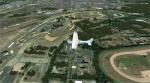
FSX/P3D LFRM Le Mans Arnage - Bugatti Cicuit, FRANCE
(Category: FSX > Scenery)
230.88Mb (418 downloads)
Photorealistic scenery for FSX (should work on P3D V 1-4). Overlapping edges from photo into default scenery. Enhanced airport close to real with custom buildings and some static objects. Day and Night textures. Some autogen at airport, circuit and surrounding areas. FTX Global and Vector compatible.
Posted Jul 7, 2021 01:32 by Ignacio Del Muro
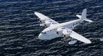
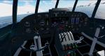
FSX/P3D Short S.23
(Category: FSX > Vintage)
7.56Mb (418 downloads)
FSX/P3D Short S.23, S.30 and S.33 Empire. Updated from the Jens B. Kristensen. These famous aircraft formed the backbone of the British national airline, Imperial Airways, it's sucessor B.O.A.C. and its partners Qantas Empire Airways and TEAL from the mid ‘thirties and through World War Two. The aircraft that survived the war were replaced by more modern aircraft in 1946-47
Posted Dec 2, 2020 05:17 by uploader