


All Time Popular > Page 4363
FS2002
ONLY : Asiana Airlines B767-38E
(Category: FS2002 > Civil Jets)
2.52Mb (418 downloads)
FS2002
ONLY : Asiana Airlines B767-38E This is a full repaint of
the POSKY Boeing B767-300 model, so it has all of their features
like fully animated flaps, gear, control surfaces etc and the
new technologies like the flex wing and chrome effect. Includes
dirt mask and night lighting effects. Repaint by James MacLeod
- ADi & JPHAS. 2.6MB
Posted Jun 23, 2008 14:34 by archive
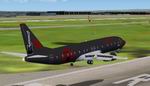
FS2004
Boeing 737-400 'Metal Air' Fantasy Textures only
(Category: FS2004 > Civil Jets)
1.28Mb (418 downloads)
FS2004
Boeing 737-400 'Metal Air' Fantasy Textures only
for the default 737-400. J.M.Barth. 1.3MB
Posted Jun 23, 2008 14:29 by archive
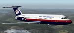
FS2004
BAC One-Eleven 304 Dan Air ex Airways Cymru Textures only
(Category: FS2004 > Civil Jets)
0.46Mb (418 downloads)
FS2004
BAC One-Eleven 304 Dan Air ex Airways Cymru Textures only.
Dan Air leased the former G-YMRU 1-11 of the defunct Airways
Cymru of Cardiff. Retaining the welsh airlines livery it was
re-registered G-BPNX Requires the BAC One-Eleven 400HK model
by David Maltby www.dmflightsim.co.uk:
Repaint Garry Russell. 443K
Posted Jun 23, 2008 14:29 by archive
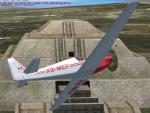
RF4-D Mexican Textures
(Category: FSX > Props)
0.37Mb (418 downloads)
Textures for the one and only Mexican registered Fournier RF4-D. Kazunori Ito's original model and on Simviation available updates needed.
Required files:
required file
Posted Apr 1, 2010 11:22 by Jean-Luc Peters
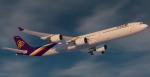
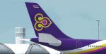
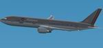
FSX/P3D Thai Airways (HS-TNA) Thomas Ruth A340-600 Textures
(Category: FSX > Civil Jets)
17.22Mb (417 downloads)
Thai Airways (HS-TNA) Texture for the Thomas Ruth A340-600 model. This texture is a part of my project to attempt to re-texture the Thomas Ruth A340s with 4096*4096 HD Textures. Special thanks to Oniel Black for helping with the slats textures. Feel free to join the JetRepaintsSG group on Facebook for more of my repaint works! Installation instructions have been included in the file. Made by Muhammad Akmal Farhan
Required files:
required file
Posted Aug 10, 2023 01:48 by Muhammad Akmal Farhan
.jpg-thumb.jpg)
.jpg-thumb.jpg)
FSX/Accel Pilotable WWII Light Cruiser USS Nashville
(Category: FSX > Misc)
11.12Mb (417 downloads)
FSX/Accel Pilotable WWII light cruiser CL43 USS Nashville. The Brooklyn class, buildt between 1935 and 1938, had five 15.2 cm trible guns and four 12.7 cm twin guns fought in the Pacific and Atlantic wars. Powered with 100.000 shp the vessel reached almost 33 knots. Some of the cruisers were sold after WWII to South America. Nashville went after WWII to the chilean Navy as Capitan Prat and was wrecked in 1983. The argentine cruiser ARA General Belgrano (former Phoenix) were sunk during the Falkland War in 1982. Now you can explore this succesful warship by toggling through twenty five cameras showing hundreds of realisticly details. Effects are seperatly configured for port and starboard. The Ai-vessel USS Helena is converted from Sketchup to native FSX by Klaus Novak and belongs to his WWII US Navy fleet at SOH. Repaint for the Nashville in 1962 Atlantic camo, 2D-panel, configurations and files for pilotable vessel by Erwin Welker
Posted Apr 18, 2022 15:02 by Erwin Welker
.jpg-thumb.jpg)
.jpg-thumb.jpg)
FSX/Acceleration/P3D Repaint OF Uenoshings J8M Akimizu To An Pseudo Me-163 Komet
(Category: FSX > Military)
22.59Mb (417 downloads)
FSX/Acceleration Repaint of Mr. Uenoshings Japanese J8M Akimizu to a German pseudo Me-163 Komet. Requires "zue_j8m1_v1.zip" The model does not reflect the real Messerschmitt Me-163 Komet! Even the Japanese J8M Akimizu is based on the Me-163, it is not a copy! The Messerschmitt blueprints, supposed to be handled to Japan, did not come to Japan and so the Japanese created an own design. Therefore there are some differences between this 2 rare and very special rocket planes. So please ingnore the differences! Original model by Mr. Uenoshing. Repaint, 2D panel and gauge reconfiguration by Erwin Welker
Required files:
required file
Posted Mar 24, 2022 03:46 by Erwin Welker
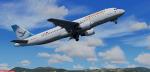
FSX/P3D Airbus A320-200 Freebird Airlines package
(Category: FSX > Civil Jets)
80.69Mb (417 downloads)
FSX/P3D Airbus A320-200 Freebird Airlines package. Freebird is a Turkish charter airline based in Istanbul and currently has 10 Airbus A320 flying to destinations around Europe and the Middle East.
This is the standard Project Airbus A320 painted to resemble a NX (neo) version with window and door placements.
Model by Project Airbus. 2020 updated VC by Speedbird77 with built in FMC by Garret Smith. Includes A320 operation manual and checklist. Airbus sounds included. Textured and assembled for P3D v5 by Chris Evans. Should work in FSX and other P3D
Posted May 10, 2021 04:49 by chris evans
P3Dv4 EBBL Kleine Brogel AB, Belgium v4.0
(Category: Prepar3d > Scenery)
42.27Mb (417 downloads)
EBBL KleineBrogel AB v4.0
for P3Dv4 only .
This is my second scenery from EBBL Kleine Brogel / Belgium 10 Fighter-Bomber Wing.
The home of 31 Sqn (Tigers), 349 Sqn and OCU.
made by Peter Ziegler
Posted Dec 8, 2017 17:44 by Peter Ziegler
Antonov An-225 Saudi Textures
(Category: FSX > Military)
15.31Mb (417 downloads)
High resolution textures only in Saudi Arabian camouflage colours for the great Antonov An-225 model created by Thomas Ruth.
New textures for fans, new wheels, corrected doors, new windows, new wings, added details, corrected bumps, new lights and specular, .... enjoy !
Requires the original package by Thomas Ruth:
Required files:
required file
Posted May 24, 2017 14:46 by Dagobert