


All Time Popular > Page 4374
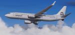
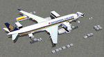
FSX/P3D Boeing 737-800 AirExplore package
(Category: FSX > Civil Jets)
63.57Mb (413 downloads)
FSX/P3D Boeing 737-800 AirExplore package. Air Explore is a charter airline based at Bratislava Airport in Slovakia, central/eastern Europe. Currently AirExplore have 7 Boeing 737-800, with 4 being leased out to different airlines.
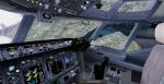
TDS high spec. native FSX Boeing 738-800 model. The VC is the FSND modified version of the Microsoft Boeing 738 VC to include various upgrades. Thank you to Alrot for this. I retextured the VC to make it more resemble the darker grey of today's 737's.
See Document folder to get the best out of the VC.
Textured, packaged and prepared for FSX & P3D up to v5 by Chris Evans.
Posted Nov 22, 2021 11:35 by chris evans
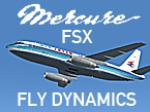
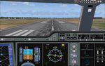
FSX fly dynamics for Mario Noriega Dassault Mercure
(Category: FSX > Civil Jets)
0.18Mb (413 downloads)
FSX Fly dynamics for Mario Noriega Dasault Mercure.
New fly dynamics without any oscillation at high altitudes, EPR values slightly modified to fit the JT8D-15 performances of the new fly dynamics, new autopilot IAS mode (IAS hold by pitch attitude variations) with optimized pitch oscillations damper.
Posted Jan 17, 2021 12:19 by Benoit Gaurant
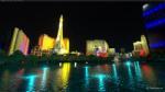
Las Vegas Night Light Pack
(Category: MSFS > Scenery)
0.03Mb (413 downloads)
This is a night light enhancement pack for Las Vegas in MSFS.
This addon adds many lights to lighten up the las vegas strip and surrounding areas. With multiple different colors matching real-life photos.
I have little to no fps impact when departing out of Las Vegas. If you were to fly a fast plane through the strip, you could experience up to 10 fps due to the high amount of lights. Aircake1
Posted Dec 4, 2020 01:30 by Fieldman
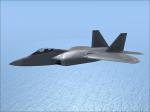
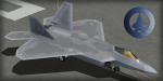
FSX IRIS Raptor Driver 27FS Textures
(Category: FSX > Military)
10.56Mb (413 downloads)
Textures for the IRIS Raptor Driver in 27th Fighter Squadron Livery (Langley AFB). FSX and P3D v3 only.
Required files:
required file
Posted Oct 8, 2020 14:39 by Dustin Kosman
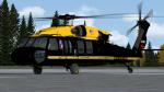
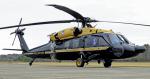
Cera Sim H-60 US Army VIP Gold Top Textures
(Category: FSX > Payware)
15.56Mb (413 downloads)
This livery depicts the VH-60M Blackhawks operated by the 12th Aviation Battalion, located at Fort Belvoir, VA. Located within the Military District of Washington, this battalion ferries the military elite of the armed forces in and around Washington, as well as the world when needs arise. This battalion works in close proximity with the USMC HMX-1 squadron (they operate Marine One) to handle most VIP missions around our nation's capital. If and when the President is on board, the official callsign has been "Army One". This repaint is for the PAYWARE CeraSim UH-60.
Posted Jan 9, 2020 00:26 by Jason Anderson
Singapore Airlines Airbus A350-900
(Category: FS2004 > Civil Jets)
3.51Mb (413 downloads)
FS2004 Singapore Airlines Airbus A350-900 ULR (Ultra Long Range) V5L. Night lighting effects have been upgraded,
also featuring the newest winglets and a new 2D panel.
Including CamSim's own static displays and Animated Ground Servicing (AGS).
Model design and paint by Camil Valiquette.
Posted Jun 22, 2018 03:13 by Camil Valiquette
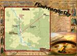
Russia-Voronezh Region Airports
(Category: FS2004 > Scenery)
30.69Mb (413 downloads)
FS2004 Scenery-Russia-Voronezh Region
H701-Kriusha, UUOQ-Voronezh (Parus), UUOX-Khava, UUOY-Voronezh (Borshchevo), XUOG-Voronezh (Gremyach'ye), XUOI-Buturlinovka, XUOW-Voronezh (Baltimor), ZA0I-Anna (Sadovoye), ZA1K-Boguchar, ZA32-ELAN'-KOLENO, ZA3H-Fomenkovo, ZA4I-Kalach, ZA4V-Kantemirovka, ZA5W-Kostino-Otdelets, ZA78-Leskovo, ZA7Q-Malyye Alabukhi, ZA85-Melovatka, ZA9Q-Ol'khovatka, ZAB1-Pavlovsk, ZAG3-Rossosh', ZAG4-Rostoshi, ZAH7-Saguny, ZAJ0-Seloma, ZAY9-Vyaznovatovka, ZB7E-Novaya Kalitva, ZB7I-Ostrogozhsk, ZC37-Talovaya, ZC7D-Bobrov, ZC7E-Davydovka, ZC7F-Chigorak, ZCS0-Talovaya-1, ZD5A-Pereleshino, ZD5B-Chernavka, ZD5C-Khokhol'skiy, ZEF9-Aleksandrovka, ZEH2-Kaver'ye, ZEP1-Ertil'
Posted Sep 28, 2015 02:43 by Andrey Anta

Boeing 737-800 XL Airways Sunweb Textures
(Category: FSX > Civil Jets)
8.62Mb (413 downloads)
XL Germany - Sunweb textures for the default FSX Boeing 737-800 .
Posted Feb 10, 2012 12:17 by Jim Fly
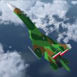
ALS-SIM Su-27 Flanker Fuerza Aerea Mexicana Textures
(Category: FSX > Payware)
4.68Mb (413 downloads)
This is a fictive FAM textures only for the payware ALS-SIM
Su-27 Flanker B.
Repaint by Black_Eagle.
Posted Jan 3, 2012 13:04 by Black_Eagle
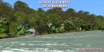
3D/2D Scenery Experiment--001
(Category: FSX > Scenery)
3.38Mb (413 downloads)
Several times I have made some 2D objects and used one here or one there. This experiment is a composition of 3D objects together with 2D ones. You will see a 2D rock mountain pertaining to be 3D, Poseidon's head cut out like the little soldiers we used to make from cardboard that stood their ground, a black and white group of 1930 bathers smiling at you, some 2D shacks embedded in the jungle etc....Like I said above this is an experiment in Beta form(???) that hopefully will be liked. I will experiment more with this type of scenery in the near future. In the mean time fly out to these two places and see for yourself....
Posted Mar 12, 2011 02:14 by Gera Godoy Canova