


All Time Popular > Page 4410
CFS
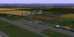
Scenery Add-On "Erfurt"
(Category: CFS1 > Scenery)
0.56Mb (403 downloads)
CFS
Scenery Add-On "Erfurt"
The "Erfurt" scenery is roughly fictional but attempt to show a detailed
depiction of this German airport located on Thuringia region, as a
Luftwaffe airbase during WWII. I include static Junkers Ju-52/3m,
Fiesler 156 Storch, Lufthansa DC-2, Focke Wulf FW-190 and FW-61 (twin
rotor helicopter). The scenery also shows searchlights placed on lookout
towers and refuel area with moving fuel truck. By Edmundo Abad. 577K
Posted Jun 10, 2008 11:32 by archive
FS98/FS2000/CFS1/CFS2
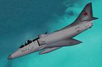
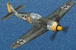
TA-4J Skyhawk 'VC-8'
(Category: CFS1 > Modern Aircraft)
0.21Mb (403 downloads)
FS98/FS2000/CFS1/CFS2
TA-4J Skyhawk 'VC-8'. Douglas TA-4j Skyhawk of VC-8 'Redtails'
operating out of Naval Station Roosevelt Roads, Puerto Rico. Bu. No.
154312. VC-8 is today the last US Navy squadron to fly the TA-4j Skyhawk.
Original by Deane Baunton. Moving Parts by Lewis Magruder. Repaint
by Jens-Ole Kjølberg. 221K
Posted Jun 10, 2008 11:32 by archive
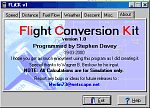
FLiCK
v1 - Flight Conversion Kit
(Category: FS2000 > Utilities)
0.15Mb (403 downloads)
FLiCK
v1 - Flight Conversion Kit A small Utility I wrote
to convert airspeed, fuel consumption, distance, Bank angles,
Descent rates, just about everything. Bu Stephen Davey 158K
Posted Jun 23, 2008 14:34 by archive
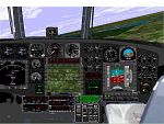
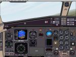
FS98
MH-53J Pavelow III Panel
(Category: FS98 > Panels)
1.36Mb (403 downloads)
FS98
MH-53J Pavelow III Panel. Equipped with FLIR, GPS, Doppler
Navigation and Terrain Avoidance Radar, the crew of 6 can put
their payload on target anywhere in the world. Panel requires
ACS-GPS. NAVSTAR is not needed for panel2. Modified by Terry.
Evans. 1.4MB
Posted Jun 23, 2008 14:21 by archive
Atr
42/72 panel for fs2000 only
(Category: FS2000 > Panels)
0.05Mb (403 downloads)
Atr
42/72 panel for fs2000 only. Uses exclusively fs2k default
gauges. Included fs2000 atr42-500 *.air file, flight dinamics
by Stefano Caputo; Panel Bitmap by N.G.Douath; Gauge rework
for fs2000 by Marco Spada - PVI Roma. Engine gauges and engines
start are active only with included air file. 51K
Posted Jun 23, 2008 14:35 by archive
Paris
Charles de Gaul increased traffic
(Category: FS2002 > Scenery)
0.01Mb (403 downloads)
Paris
Charles de Gaul increased traffic.
For use wiuth AFCAD (available
here) F.KABALU. 16K
Posted Jun 23, 2008 14:31 by archive
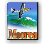
FS2002
Moorea Airport, Temae, Island of Moorea, French Polynesia
(Category: FS2002 > Scenery)
1.88Mb (403 downloads)
FS2002
Moorea Airport, Temae, Island of Moorea, French Polynesia...
This scenery redoes the main terminal at Moorea airport, and
adds a sea plane base in the lake near the end of the runway,
plus a luxury resort hotel on the bay behind the airport. The
scenery includes parking areas, roadways, boat and seaplane
docks, sail boats out in the bay, indigenous landscaping, and
nice night lighting effects....NTTM By: Bill Melichar. 1.9MB
Posted Jun 23, 2008 14:31 by archive
FS2000
- the original CFS P-47d Thunderbolt in Sky Blue Camouflage
adapted for FS2K
(Category: FS2000 > Vintage)
0.80Mb (403 downloads)
FS2000
- the original CFS P-47d Thunderbolt in Sky Blue Camouflage
adapted for FS2K. This is a repaint of the default CFS P-47d
Thunderbolt aircraft painted in Sky Blue Camouflage. The Aircraft
color scheme was taken from an original photograph, This aircraft
is from CFS and tested in FS2000. Uses P-47d Panel. It will
fly equally well in CFS and FS2000. All flight surfaces are
moveable, transparent cockpit, retractable landing gear. Repaint
by Bob Bongiovanni. 836K
Posted Jun 23, 2008 14:34 by archive
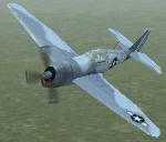
FS2000
- CFS FW190a in Gray/Olive Camouflage.
(Category: FS2000 > Vintage)
1.09Mb (403 downloads)
FS2000
- CFS FW190a in Gray/Olive Camouflage. This is a repaint
of the default CFS FW190a aircraft painted in Gray/Olive Camouflage
textures based on an original picture with the numbers 7-11
on the side. This file contains an extra skin with Swastika
on the tail as flown on the actual aircraft. This aircraft is
from CFS and tested in FS2000. Uses Fw 190a Panel. It will fly
equally well in CFS and FS2000. All flight surfaces are moveable,
retractable landing gear. Repaint by Bob Bongiovanni. 1.1MB
Posted Jun 23, 2008 14:34 by archive
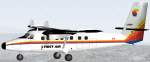
1st
Air DHC 6 Twin Otter
(Category: FS98 > Props)
0.15Mb (403 downloads)
FS98
1st
Air DHC 6 Twin Otter with moving parts. File size 157445.
J de Miranda
Posted Aug 24, 2009 06:42 by archive