


All Time Popular > Page 4440
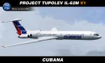
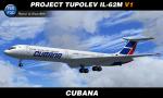
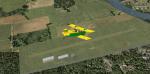
Cubana Ilyushin IL-62M - Textures
(Category: FSX > Civil Jets)
63.22Mb (388 downloads)
FSX/P3D Project Tupolev IL-62M v1 Cubana livery. Texture only for new freeware PT IL-62M v1 model. Link to forum & model: www.avsim.su/forum/topic/198389-пт-ил-62м-бета-2-fsx-p3d-34-p3d-45/ Paint Kit & Repaint by Sergey Gleba aka serg09. Link to my products on SimMarket: http://secure.simmarket.com/paintsim.mhtml
Posted Oct 20, 2021 13:40 by Sergey Gleba aka serg09
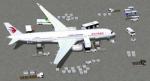
China Eastern Airbus A350-900
(Category: FSX > Civil Jets)
10.33Mb (388 downloads)
FSX China Eastern Airbus A350-900 AGS V6.
New Animated Ground Servicing.
New static displays.
New winglets.
New wing root.
New landing / taxi soft light beams.
New 2D panel. (no VC)
Model design and paint by Camil Valiquette.
Posted Feb 16, 2019 06:04 by Camil Valiquette

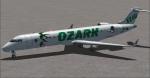
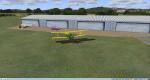
Ozark Airlines Default 737/CRJ700 Textures
(Category: FSX > Civil Jets)
3.91Mb (388 downloads)
Ozark Airlines repaints for the default FSX 737-800 and CRJ-700 aircraft. These are purely fictional liveries of what Ozark's fleet might look like if the airline were still in existence and flying typical modern aircraft. When Ozark Airlines was integrated into TWA, their fleet consisted of 50 DC-9's and a handful of MD-80 series aircraft.
Posted May 16, 2016 19:09 by Frank Kaim
EPMO Modlin, Poland, 2009
(Category: FS2004 > Scenery)
132.98Mb (388 downloads)
EPMO MODLIN 2009 features an extremely detailed scenery of military airfield near Warsaw, Poland, fully compatible with FS2004. In the past it was a payware scenery, but Drzewiecki Design decided to provide you that old full product for FREE!
The airport was upgraded around 2012 and currently it has a nice passenger terminal and serves low-cost carriers like Ryanair, however back in 2009 it was an almost abandoned military airfield with some amazing structures inside. This scenery shows the status of Modlin aiport in 2009 having many tumble-down buildings, deformed and rusty metal stairs and much more. Nothing has left of that old airport by now but using our scenery you can go back in time and check for yourself how it looked like.
The scenery features accurate positioning, modelling and texturing, high quality photoreal textures of all airport buildings (some buildings include interior) and high quality aerial photos of the airport. The package also includes charts and airfield specification.
The product is equipped with an automatic installer, but you need to manually add the airport into the Flight Simulator Scenery Library (see attached manual). Please uninstall all previous versions of this airport you may have installed before. Please make also sure that no duplicated AFCAD files are installed.
Enjoy your virtual flying with Drzewiecki Design!
Posted Aug 28, 2015 07:10 by Drzewiecki Design
Russia - Omsk Region Airports
(Category: FS2004 > Scenery)
24.02Mb (388 downloads)
Russia Omsk region airports :
UNOC-Chapayevo, UNOF-Omsk (Fedorovka), UNOS-Omsk (Severniy), XNOM-Omsk (Mar'yanovka), ZC20-Tyukalinsk, ZCA2-Sedel'nikovo, ZDL5-Omsk (Kobra), ZEB3-Omsk (Kamyshino), ZEJ9-Kolosovka, ZES6-Bol'shiye Uki
Posted Jan 30, 2015 14:04 by Andrey Anta
Blue Swan (Abandoned) N32 Sayre PA
(Category: FSX > Scenery)
0.00Mb (388 downloads)
Blue Swan N32 (abandoned)
Located in Sayre PA, the Blue Swan airport Served northern Bradford County PA and Waverly NY. IT survived until 2004.Now it is impossible to find on google earth even if you know Where it was. Replaced by huge industrial parking lots this once charming small town airport is another gone forever.
Posted Jun 25, 2014 02:29 by Jon Davidson
Germany - Peenemunde
(Category: CFS2 > Scenery)
0.48Mb (388 downloads)
This scenery package represents the German research facility located at Peenemünde, Germany. This was a primary German Army research facility, and an important component of the German rocket program, which included construction of both V1 and V2 rockets. It became a priority for both British and American heavy bombers, beginning in 1943. The Germans initially believed that its distance from Britain would render it safe from Allied bombing raids, but this proved not to be the case.
Warning: Some of the GSL scenery may be a bit hard on frame rates, but this was tested on my lower-end rig, and the frame rates were acceptable.
Posted Jan 2, 2014 18:41 by Andrew Talbot
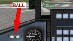
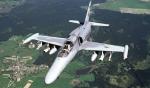
Aero Vodochody L159A Widescreen 2D panel: patch
(Category: FSX > Panels)
0.01Mb (388 downloads)
Ball gauge missing in the first upload. Sorry about that. Here it is.
Required files:
required file
Posted Oct 6, 2012 03:35 by Jean-Luc Peters
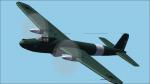
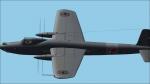
F Giulli MB902
(Category: CFS2 > Aircraft)
22.21Mb (388 downloads)
An extremely unorthodox design, the all-metal MB.902 mounted two 1475 h.p. FIAT R.A.I050 R.C.58 Tifone (license-built DB 605A) twelve-cylinder vee engines buried in the fuselage and driving twin contra-rotating airscrews in the wings by extension shafts.
Posted May 27, 2012 02:37 by Pepe Rezende
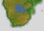
ASTER GDEMv2 30m mesh for Namibia & Botswana Pt2
(Category: FSX > Terrain Mesh)
158.51Mb (388 downloads)
There are four parts to download for this area of Africa.
ASTER GDEM Version 2 is a 30 metre definition DEM, its better than the version 1 data that ERSDAC, of Japan and NASA originally released, but it does have its limitations.
GDEM has been obtained from a satellite that uses stereoscopic infrared scanning cameras, this brings with it problems in the resultant data.....where it sees the tops of trees, buildings etc, as the ground terrain.
If you look at the jpg image with the terrain type errors shown as a graph, you will see that the only 'safe' terrain to use this data with - in FSX - is scrubland, or desert terrain.
Its hopeless in defining the terrain in places like Europe - with all the artificial structures, (buildings) and different types of woodland, so any mesh I create from this data won't include areas like that....it will be more desert type terrain, and scrubland.
I won't be doing Greenland because something about the ice around Greenland, (or any other land mass with ice) it creates false data.
It does give enough fine data to reveal railway lines, and some roads though.
This mesh has been made for FSX only.
Grateful thanks to ERSDAC, and NASA for making this data freely available to the public.
ASTER GDEM
Copyright (c) 2009 - 2011 Earth Remote Sensing Data Analysis Center (ERSDAC) All rights reserved.
ASTER GDEM is a product of METI and NASA.
Posted May 5, 2012 05:55 by Wayne Evans