


All Time Popular > Page 4505
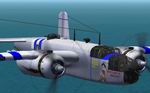
B-25B
Mitchell default repaint "Destiny's Desire"
(Category: CFS2 > Aircraft)
1.59Mb (369 downloads)
B-25B
Mitchell default repaint "Destiny's Desire" Named after C/O
VMA_Falcons Fiancee Used in Bomb-Runs (CFS2) Robert (VMA_Falcon) Heun.
1.6MB
Posted Jun 10, 2008 11:31 by archive
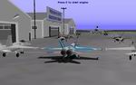
V2
launcher/carrier
(Category: CFS1 > Misc)
1.29Mb (369 downloads)
V2
launcher/carrier Model By: Microsoft the Rest By: Andrew Tremblay
simply install it like any other aircraft and have fun!, use F11 and
F12 to steer. 1.3MB
Posted Jun 10, 2008 11:09 by archive
CFS1
Modern day NATO jet field,
(Category: CFS1 > Scenery)
0.77Mb (369 downloads)
CFS1
Modern day NATO jet field,
set in Juvaincourt France. Static aircraft include, FA-18, F-22, EF2000,
RAF Typhoon and a KC-10 refueler. Most all buildings and objects painted
light grey. Refuel area, NDB, VOR, ATIS, Outer middle and inner markers
Freeware Rick Herring. 792K
Posted Jun 10, 2008 11:32 by archive
CFS
Scenery - Scotland
(Category: CFS1 > Scenery)
0.29Mb (369 downloads)
CFS
Scenery - Scotland Elevated Mesh scenery of Scotland from
the Orkneys and Outer Hebrides down to the Default CFS England Scenery.
Airfields at several places (including Loch Ness). Covers all of Scotland
and Northern England and all Scottish Islands except Shetland (160,000
sq km/62,000 sq miles). Includes optional "Seasonal" Classlist. By
Martin Wright. 302K
Posted Jun 10, 2008 11:32 by archive
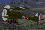
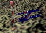
Royal
Aircraft Factory S.E.5
(Category: CFS1 > Aircraft)
0.08Mb (369 downloads)
Royal
Aircraft Factory S.E.5 Serial No. D3542 from No. 6 Sqdn., AFC,
1917 Repaint with new Mdl , Air and Dp files By A.F.Scrub. February
2003 The S.E.5 was fast and rugged. Although it did not have the agility
of the Camel, it served as a steady gun platform. Several of the most
famous British and Commonwealth fliers achieved their successes in
the S.E.5. 78K
Posted Jun 10, 2008 11:32 by archive
Excel
Flight Log
(Category: FS2000 > Utilities)
0.19Mb (369 downloads)
Excel
Flight Log - Internationl Version A very simple freeware
logbook that is perfect for flight simulation. All you need
is Excel. In this version you can input hours and minutes,
the standard for log books for ICAO. By: CJ Starr. 193K
Posted Jun 23, 2008 14:34 by archive
Air Race Markers API Collection.
(Category: FS Design > Scenery Design Objects)
0.12Mb (369 downloads)
Air
Race Markers API Collection.
9 Markers with Finish. 121K
Posted Jun 23, 2008 14:18 by archive
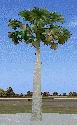
FS2004 Scenery Macro jmhatpalm. Palm Tree Macro
(Category: FS Design > Scenery Design Objects)
0.09Mb (369 downloads)
FS2004
Scenery Macro jmhatpalm. Palm Tree Macro.
Texture and macro by jimmy R martin. Night lighted. Resource
included. Airport for Windows api. FS2004 only. 90K (see fix
below)
Posted Jun 23, 2008 14:18 by archive
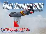
FS2004
F-86F Ascua Splashscreen set
(Category: Videos/Splashscreens > Splashscreens)
2.41Mb (369 downloads)
FS2004
F-86F Ascua Splashscreen set.
4 Splashscreens. José A. Arruga. 2.5MB
Posted Jun 23, 2008 14:14 by archive
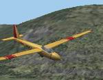
FS2004 Thermals Weather Theme
(Category: FS2004 > Gliders and Ultralites)
0.20Mb (369 downloads)
FS2004
Thermals Weather Theme A
weather theme to go alongside all the others in the list for
gliding. You will find a greater ammount of lift over the
darker ground and the gliding gets harder to the north. Enjoy.
Bracken Dawson. 207K
Posted Jun 23, 2008 14:18 by archive