


All Time Popular > Page 4614
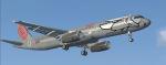
FSX default Airbus A321 'FlyNiki' Textures
(Category: FSX > Civil Jets)
1.21Mb (337 downloads)
FlyNiki textures for the default FSX Airbus A321. Niki was an Austrian airline founded by Formula 1 Racing driver Niki Lauda. In 2018, Niki was absorbed into Lauda, now part of Ryanair.
Posted Oct 16, 2019 02:24 by Marius Flieger

Airbus A320-214 LaudaMotion
(Category: FS2004 > Civil Jets)
13.70Mb (337 downloads)
Airbus A320-214 LaudaMotion OE-LOE. This is a repaint of the Project Airbus A320-214, in LaudaMotion livery, registration OE-LOE. Model included. The textures are saved in 32 bit format for quality graphics. Shine effect. Contains accurate model with details such as: opening passenger and cargo doors, animated pack inlets and outflow valves, all operable control surfaces, detailed flap tracks and slat rails, hydraulics modelled on spoilers, landing gear doors and many more. By Stefan Bree.
Posted Sep 18, 2018 07:15 by chrisE
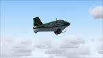
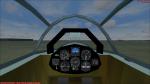
FS2004 only Mitsubishi J8M1 Shusui (Japanese Komet version)
(Category: FS2004 > Vintage)
18.12Mb (337 downloads)
FS2004 only Mitsubishi J8M1 Shusui (Japanese Me-163 Komet version) with independent working skid and trolley, so you can start on the trolley and land on the skid. Nice 2D and rudimentary VC, both with working Japanese gauges (all included) and extra panels, also smoke- and guneffects for fun. Updated soundfile with glidersounds. All credits go to Ignacio Alfredo Mendive, the original designer. Enjoy!
Posted Jul 24, 2018 16:09 by Erik Hertzberger

Mocha Island LOD10 Mesh HD - Chile
(Category: FSX > Terrain Mesh)
0.30Mb (337 downloads)
Mesh for the Isla de Mocha in Chile. Quality lod 10 - Mocha Island is an island located off the coast of the province of Arauco in the Biobio Region, Chile, 34.2 kilometers from Tirua La isla Cuenta con aproximadamente 48 Km2 - Coordinates: 38°22′15 S 73°54′51 O. Mesh compatible with all kind of terrain addons
Posted Mar 15, 2017 22:54 by juan30005
Russia-Primorskii Krai area airports
(Category: FS2004 > Scenery)
3.80Mb (337 downloads)
FS2004 Scenery-Russia-Primorskii krai
HA5E-Sukhaya Rechka, UHBL-Arsenyev (North), UHHA-Ada, UHHD-Dal'nerechensk, UHHL-Olon, UHTG-Amgu, UHTI-Kiyevka, UHTL-Laukhe, UHTM-Maksimovka, UHTQ-Svetlaya, UHTS-Samarga, UHTW-Vostok-2, UHTY-Unty, UHTZ-Agzu, UHWD-Dal'negorsk, UHWE-Edinka, UHWK-Kavalerovo, UHWP-Plastun, UHWR-Roschino, UHWS-Serafimovka, UHWT-Terney, XHID-Golubovka, XHIE-Chernyshevka, XHIN-Voznesenka, XHIW-Voskresenka, XHWM-Mikhaylovka, XHWO-Barano-Orenburgskiy, ZA5M-Koksharovka, ZA6Z-Lastochka, ZAW3-Velikaya Kema, ZC32-Lazo, ZD2G-Petrovka (Vladivostok), ZD2X-Avdeyevka, ZD2Y-Guberovo, ZD32-Verkhniy Pereval, ZD6N-Uzhaya Uglovaya (Vladivostok), ZE06-Patrokl (Vladivostok), ZE3Y-Milogradovo
Posted Sep 15, 2015 17:00 by Andrey Anta
10m Finland mesh K
(Category: FSX > Terrain Mesh)
25.39Mb (337 downloads)
G'day Cobbers,
This mesh was produced with 10m dem data and is the first of thirteen files that covers all of Finland.
Thanks and enjoy
Posted Oct 31, 2014 08:48 by Brett Simtropolis

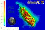
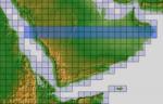
ASTER GDEMv2 30m mesh for Arabian Peninsula Pt6a
(Category: FSX > Terrain Mesh)
61.36Mb (337 downloads)
There are Twenty parts of this mesh to download as separate files.
ASTER GDEM Version 2 is a 30 metre definition DEM, its better than the version 1 data that ERSDAC, of Japan and NASA originally released, but it does have its limitations.
GDEM has been obtained from a satellite that uses stereoscopic infrared scanning cameras, this brings with it problems in the resultant data.....where it sees the tops of trees, buildings etc, as the ground terrain.
If you look at the jpg image with the terrain type errors shown as a graph, you will see that the only 'safe' terrain to use this data with - in FSX - is scrubland, or desert terrain.
Its hopeless in defining the terrain in places like Europe - with all the artificial structures, (buildings) and different types of woodland, so any mesh I create from this data won't include areas like that....it will be more desert type terrain, and scrubland.
I won't be doing Greenland because something about the ice around Greenland, (or any other land mass with ice) it creates false data.
It does give enough fine data to reveal railway lines, and some roads though.
This mesh has been made for FSX only.
Grateful thanks to ERSDAC, and NASA for making this data freely available to the public.
ASTER GDEM
Copyright (c) 2009 - 2011 Earth Remote Sensing Data Analysis Center (ERSDAC) All rights reserved.
ASTER GDEM is a product of METI and NASA.
Posted Mar 8, 2012 05:00 by Wayne Evans
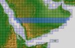
ASTER GDEMv2 30m mesh for Arabian Peninsula Pt5a
(Category: FSX > Terrain Mesh)
83.55Mb (337 downloads)
There are Twenty parts of this mesh to download as separate files.
ASTER GDEM Version 2 is a 30 metre definition DEM, its better than the version 1 data that ERSDAC, of Japan and NASA originally released, but it does have its limitations.
GDEM has been obtained from a satellite that uses stereoscopic infrared scanning cameras, this brings with it problems in the resultant data.....where it sees the tops of trees, buildings etc, as the ground terrain.
If you look at the jpg image with the terrain type errors shown as a graph, you will see that the only 'safe' terrain to use this data with - in FSX - is scrubland, or desert terrain.
Its hopeless in defining the terrain in places like Europe - with all the artificial structures, (buildings) and different types of woodland, so any mesh I create from this data won't include areas like that....it will be more desert type terrain, and scrubland.
I won't be doing Greenland because something about the ice around Greenland, (or any other land mass with ice) it creates false data.
It does give enough fine data to reveal railway lines, and some roads though.
This mesh has been made for FSX only.
Grateful thanks to ERSDAC, and NASA for making this data freely available to the public.
ASTER GDEM
Copyright (c) 2009 - 2011 Earth Remote Sensing Data Analysis Center (ERSDAC) All rights reserved.
ASTER GDEM is a product of METI and NASA.
Posted Mar 8, 2012 04:20 by Wayne Evans
ASTER GDEMv2 30m mesh for Arabian Peninsula Pt4d
(Category: FSX > Terrain Mesh)
51.64Mb (337 downloads)
There are Twenty parts of this mesh to download as separate files.
ASTER GDEM Version 2 is a 30 metre definition DEM, its better than the version 1 data that ERSDAC, of Japan and NASA originally released, but it does have its limitations.
GDEM has been obtained from a satellite that uses stereoscopic infrared scanning cameras, this brings with it problems in the resultant data.....where it sees the tops of trees, buildings etc, as the ground terrain.
If you look at the jpg image with the terrain type errors shown as a graph, you will see that the only 'safe' terrain to use this data with - in FSX - is scrubland, or desert terrain.
Its hopeless in defining the terrain in places like Europe - with all the artificial structures, (buildings) and different types of woodland, so any mesh I create from this data won't include areas like that....it will be more desert type terrain, and scrubland.
I won't be doing Greenland because something about the ice around Greenland, (or any other land mass with ice) it creates false data.
It does give enough fine data to reveal railway lines, and some roads though.
This mesh has been made for FSX only.
Grateful thanks to ERSDAC, and NASA for making this data freely available to the public.
ASTER GDEM
Copyright (c) 2009 - 2011 Earth Remote Sensing Data Analysis Center (ERSDAC) All rights reserved.
ASTER GDEM is a product of METI and NASA.
Posted Mar 7, 2012 13:22 by Wayne Evans
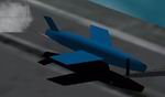
The
Regulus1 Ship launched cruise missile of the 1950's
(Category: CFS2 > Misc)
0.11Mb (337 downloads)
The
Regulus1 Ship launched cruise missile of the 1950's.Rocket exhaust
was made by Jeff Delhaye AKA Wuhwuzdat Nuke effects are the Manhaton
project. Gerald Goldsmith. 108K.
Posted Jun 10, 2008 11:09 by archive