


All Time Popular > Page 4666
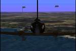
Omaha
and 2nd Ranger Battalion beach scenery, Normandy, France
(Category: CFS1 > Scenery)
0.17Mb (323 downloads)
Omaha
and 2nd Ranger Battalion beach scenery, Normandy, France.
Designed by Stev Fairs. 174K
Posted Jun 10, 2008 11:32 by archive
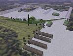
CFS
Scenery Add-On Muenster / Germany 1941
(Category: CFS1 > Scenery)
0.57Mb (323 downloads)
CFS
Scenery Add-On Muenster / Germany 1941 This download includes
all necessary textures! The airfield shows again a new set of photorealistic
WWII buildings I have designed. The scenery includes also 100km of
the so called "Kammhuberriegel" a line of searchlights and sound locators
to detect incomming bombers of the allies. The scenery was designed
with the "Airfield Construction Kit" using CFSMap from Martin "Wizard"
Wright. By Ralf-J. Triebel (X_MAT). 589K
Posted Jun 10, 2008 11:32 by archive
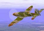
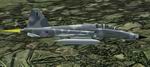
CFS1
Me 262 Damage Profiles.
(Category: CFS1 > Aircraft)
0.08Mb (323 downloads)
CFS1
Me 262 Damage Profiles.
A set of three DP files for a Me-262. These files give the Me-262
of your choice the armament of planned later versions. (C,D, & E)
All of these were prototypes on the drawing board when the war ended.
The C was equipped with .50 caliber guns. The D was armed with TWELVE
55mm mortarrifles to handle those pesky Allied bombers. The E version
was built as an interceptor and, along with the usual 4 30mm cannons,
carried 48 air to air rockets. Info found in "World War II: Encyclopedia
of the War Years 1939-1945". Made using DPED 0.95. By Will Latham.
86K
Posted Jun 10, 2008 11:32 by archive
CFS1
Spanish He 112B-2
(Category: CFS1 > Aircraft)
0.48Mb (323 downloads)
CFS1
Spanish He 112B-2 with full moving parts and in the colors
of aircraft 5*61 of 1 Escuadrilla, Grupo 27 in Spanish Morocco, 1943.
Spain acquired 19 He 112B's and they served from the Spanish Civil
War till the last two 112's were written off in 1952. Spanish He 112's
in North Africa clashed with the Vichy French Algerian D.520 fighters
of the Vichy Naval forces. In March 1943, Grupo 27 He 112B number
5*68 shot and damaged a U.S. P-38F of the 14th Fighter Group and forced
it down by the Mulluya River. Spanish Heinkels were used for tactical
strafing and bombing during the Civil War and Capitan Garcia Pardo
downed a Republican I-16 Rata in January, 1939. Jumo 210Ga / 700hp
2 X 7.9mm / 2 X 20mm / 2 X 22 lb fragmentation bombs Alias CFS panel
and sound, everything else original by Michael Hart . 487K
Posted Jun 10, 2008 11:32 by archive
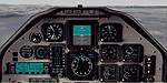
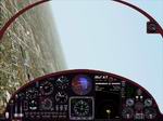
Raytheon
T-6A Texan
(Category: FS98 > Panels)
1.52Mb (323 downloads)
Raytheon
T-6A Texan, also very suitable for Pilatus PC7 or PC9. File
size 1589637
Posted Jun 23, 2008 14:21 by archive
FS2000
Panel for Chuck Dome's outstanding MiG-AT.
(Category: FS2000 > Panels)
1.07Mb (323 downloads)
FS2000
Panel for Chuck Dome's outstanding MiG-AT.
(here)Extensive
use of non-standard guages and a nice gentle night effect with
pinked instruments. Includes optional twin-tank reduced fuel
air file for heightened range/endurance realism. For FS2000
Pro, 1024x768 by Gary Smith. 1MB
Posted Jun 23, 2008 14:35 by archive
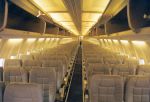
FS2000
Replacement of the 737-400 rearview
(Category: FS2000 > Panels)
2.01Mb (323 downloads)
FS2000
Replacement of the 737-400 rearview. I have also included
a 737-400 winampskin. Frank Elfert. 2MB
Posted Jun 23, 2008 14:35 by archive
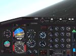
FS2000
Panel Boeing 707
(Category: FS2000 > Panels)
(323 downloads)
FS2000
Panel Boeing 707. But is is also compatible with the earlier
A330. by: Frank Elfert. 2.5MB
Posted Jun 23, 2008 14:36 by archive
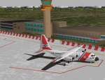
FS98/FS2000
Curacao Hato Airport TNCC
(Category: FS98 > Scenery)
0.21Mb (323 downloads)
FS98/FS2000
Curacao Hato Airport TNCC V3.1 This scenery features a detailed
version of the International Airport of the Island of Curacao,
HATO aka "Dr. Albert Plesman". It includes detailed and accurate
buildings, runwaytextures, taxiway signs & lining, parking positions
which have working marshallers who guide you how to park your
plane. This new version has been totally re-designed with help
of a local ALM Pilot to make it as accurate as possible. V3.1
is made compatible with FS2000. By Marcel Ritzema. 209K
Posted Jun 23, 2008 14:20 by archive
RF5FTUDM.zip
RF-5F* TUDM Malaysian Air Force
(Category: FS2002 > Military)
2.01Mb (323 downloads)
RF5FTUDM.zip
RF-5F* TUDM Malaysian Air Force (*painted Imagination) requires
F-5F_TigerII_CO_t.zip (here)
for full function... with updated and preassembled *.cfg & *.air
File for that Package ... see *.pdf Doc inside Bernhard Behle.
2MB
Posted Jun 23, 2008 14:33 by archive