


All Time Popular > Page 4668
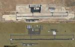
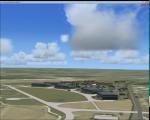
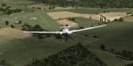
St. George Regional KSGU, St. George, Utah
(Category: FSX > Scenery)
7.82Mb (322 downloads)
St. George Regional KSGU, St. George, Utah for FSX.
The KSGU depicted in the stock FSX scenery was closed in 2011 and operations moved to the new KSGU built approx. 6 miles to the south east. This is the new version, the old one has been removed. As per charts here is no ILS approach for R1, and the localizer for R19 is offset by 7 degrees. See Skyvector.com for charts. By Sidney Schwartz
Posted Sep 25, 2018 04:40 by uploader
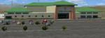
Pangborn Memorial, Wenatchee, Washington
(Category: FSX > Scenery)
3.81Mb (322 downloads)
Pangborn Memorial, Wenatchee, Washington, for FSX.
A small airport, but Alaska has regular service with mostly Dash-8's and the occassional 737. Completely re-done. RWY 7/25 removed; RWY 12/30 lengthened to 7000'; ILS R12 added. All custom buildings.
Installation: Unzip Wenatchee KEAT.zip. Move the entire folder Wenatchee KEAT into your FSX/ADDON SCENERY folder and add it to your FSX Scenery Library list.
Thanks to: Jon "Scruffyduck" Masterson for his wonderful Airport Design Editor X and other tools, Arno Gerritson for his wonderful Model Converter X and other tools, and the folks at Trimble for the free version of Sketchup. By Sidney Schwartz
Posted Jul 31, 2018 05:20 by uploader

RAF Predannack FSX/P3D Scenery
(Category: FSX > Scenery)
3.13Mb (322 downloads)
RAF Predannack was opened in May 1941 as a satellite for RAF Portraits. Accommodation was dispersed over a wide area, with officers accommodated in the Mullion Cove and Polurian Hotels. The number of personnel reached peak strength of 3,600 by 1944.
The first squadron to arrive was 247 Squadron with Hawker Hurricanes, specialising in night defence of the South West's towns and ports. The night fighting element was later augmented by 1457 Flight flying Douglas Havocs with its unsuccessful Turbinlite searchlight tactics. However, the arrival of 600 Squadron with radar equipped Bristol Beaufighters produced better results. GCI (Ground Control Interception) in the area was covered by RAF Treleaver radar station.
A more detailed history can be found on Wikipedia.
Posted May 17, 2017 06:20 by Terry Boissel
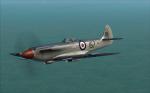
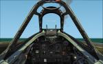
FAA Seafire Mk17 1833 NAS
(Category: CFS2 > Aircraft)
5.28Mb (322 downloads)
Sea Fire MK XVIIfor CFS2.
Original FSX/FS9 model by Scrub.
Note: Scrub kindly allowed me to modify this model in Gmax specially for my CFS2 texture. Textures made for the original FSX/FS9 model will not fit this model.
There is a 2D panel for the late Spitfires in high res wide screen format included.
Everything needed for the installation is included except the SOUND folder.
Posted Mar 26, 2017 14:18 by Morton
RAF Driffield, UK
(Category: FSX > Scenery)
1.35Mb (322 downloads)
RAF Driffield is a former Royal Air Force station located 1.7 miles (2.7km) south west of Driffield. The site was first opened in 1918 by the Royal Air Force (RAF) under the name of RAF Eastburn, before closing in early 1920. However, in 1935 a new airfield was built for the RAF initially training bomber crews before closing in 1977 when the site was turned over to the Army for use as a driving school being renamed Alamein Barracks.
Posted Feb 22, 2016 10:43 by Terry Boissel
GQNN - Nouakchott, Mauritania
(Category: FSX > Scenery)
0.00Mb (322 downloads)
GQNN - Nouakchott. Nouakchott International Airport is an international airport located in Nouakchott, the capital of Mauritania.Created in ADEX 1.16. Added from the stock airport - Taxiway A named.
Taxiway B added.
Main apron parking spots adjusted to match real-world charts and satellite imagery.
Aprons adjusted.
Taxisigns added.
Posted Nov 5, 2014 04:19 by Scott Norton
Jolamtra Landing area Bath NY
(Category: FSX > Scenery)
0.00Mb (322 downloads)
23NY Jolamtra
This small private field atop a mountain near Bath NY is used often as a landmark and turnpoint for Harris Hill soaring tasks as well as an outlanding site. In years past several model aircraft shows and flyins were held there.
Posted Jun 25, 2014 02:26 by Jon Davidson
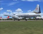
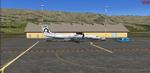
Martin 202 Northwest 1949 Textures
(Category: FS2004 > Vintage)
3.36Mb (322 downloads)
FS9/FSX Martin 202A in Northwest factory colors circa 1949.
Requires m202a.zip available at CaliforniaClassics.
Model by Dee Waldron. Textures by Gary Harper.
Required files:
required file
Posted Jul 3, 2012 17:10 by Gary Harper
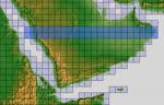
ASTER GDEMv2 30m mesh for Arabian Peninsula Pt4a
(Category: FSX > Terrain Mesh)
51.06Mb (322 downloads)
There are Twenty parts of this mesh to download as separate files.
ASTER GDEM Version 2 is a 30 metre definition DEM, its better than the version 1 data that ERSDAC, of Japan and NASA originally released, but it does have its limitations.
GDEM has been obtained from a satellite that uses stereoscopic infrared scanning cameras, this brings with it problems in the resultant data.....where it sees the tops of trees, buildings etc, as the ground terrain.
If you look at the jpg image with the terrain type errors shown as a graph, you will see that the only 'safe' terrain to use this data with - in FSX - is scrubland, or desert terrain.
Its hopeless in defining the terrain in places like Europe - with all the artificial structures, (buildings) and different types of woodland, so any mesh I create from this data won't include areas like that....it will be more desert type terrain, and scrubland.
I won't be doing Greenland because something about the ice around Greenland, (or any other land mass with ice) it creates false data.
It does give enough fine data to reveal railway lines, and some roads though.
This mesh has been made for FSX only.
Grateful thanks to ERSDAC, and NASA for making this data freely available to the public.
ASTER GDEM
Copyright (c) 2009 - 2011 Earth Remote Sensing Data Analysis Center (ERSDAC) All rights reserved.
ASTER GDEM is a product of METI and NASA.
Posted Mar 7, 2012 12:27 by Wayne Evans
.jpg-thumb.jpg)
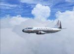
Douglas DC-9-32 Avensa YV-70C Textures
(Category: FS2004 > Civil Jets)
1.64Mb (322 downloads)
Douglas DC-9-32 Avensa YV-70C textures only for the SGA DC-9-30.
Required files:
required file
Posted Sep 29, 2011 15:25 by Luis Villanueva