


All Time Popular > Page 4964
FS2000
T-28C Weather research (storm chaser) panel update
(Category: FS2000 > Panels)
1.42Mb (244 downloads)
FS2000
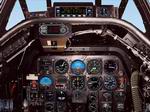
T-28C Weather research (storm chaser) panel update by Mike
Field and John Spangler. These files will install an updated
instrument panel for the T-28 Storm Chaser aircraft released
earlier. This panel allows the user to easily access both VFR
and IFR panels in one aircraft. It also includes improved bitmaps
of the panel. John Spangler. 1.5MB
Posted Jun 23, 2008 14:35 by archive
FS2000
Panel for the new Saab 2000
(Category: FS2000 > Panels)
0.46Mb (244 downloads)
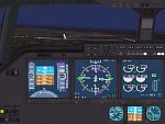
FS2000
Panel for the new Saab 2000.by: Frank Elfert. 476K
Posted Jun 23, 2008 14:36 by archive
FS2000
night lit P-51 gauges
(Category: FS2000 > Panels)
0.29Mb (244 downloads)
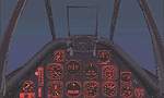
FS2000
night lit P-51 gauges. Adds the soft pink night lighting
to the default P51D.GAU file. By Chuck Dome. 299K
Posted Jun 23, 2008 14:36 by archive
RAF/USAAF
Burtonwood 1940/1945 for FS95/98
(Category: FS98 > Scenery)
0.52Mb (244 downloads)
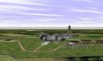
RAF/USAAF
Burtonwood 1940/1945 for FS95/98 By Mike Dews and researched
by Steve Anderson. Designed specifically for Perfect Flight
UK One and VFR Wales (but may work with others) RAF/USAAF Burtonwood
has been designed to be as accurate as possible,as it was in
WWII, but owing to the 256K scenery limit of Flight Simulator98
much detail has had to be omitted. The hangars, I hope are accurate
but the thousand or so Nissen huts have had to go. 528K
Posted Jun 23, 2008 14:20 by archive
FS98
Olympia, Washington
(Category: FS98 > Scenery)
0.32Mb (244 downloads)
FS98
Olympia, Washington with trees, buildings, etc. File size
332739. R Diebold
Posted Jun 23, 2008 14:20 by archive
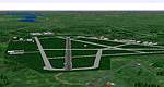
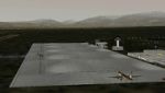
Royal
Air Force Leuchars Scenery for FS 2000
(Category: FS2000 > Scenery)
0.29Mb (244 downloads)
Royal
Air Force Leuchars Scenery for FS 2000 This file replaces
the default Leuchars AB in FS2000. RAF Leuchars is the most
Northern fighter base in the UK, and one of the busiest aswell.
On any given day you can be sure to see activity of one form
or another. The Station is a 24 hour emergency diversion airbase
so in effect it never closes. Based at RAF Leuchars are No.
43 Squadron `The Fighting Cocks` and 111 (Trebleone) Squadron
both of which are equipped with the Tornado F3. 294K
Posted Jun 23, 2008 14:35 by archive
Granada,
Spain, scenery for FS2000.
(Category: FS2000 > Scenery)
1.82Mb (244 downloads)
Granada,
Spain, scenery for FS2000. Includes night ilumination (buildings
and parking, PAPIS visible at night), static and dynamic scenery.
As a bonus, includes the new VOR at Somosierra (near Madrid),
used in the new SID's from Barajas. By José M. Barruezo. 1.9MB
Posted Jun 23, 2008 14:35 by archive
Louisville,
Kentucky Version 7.0 For use with FS2000
(Category: FS2000 > Scenery)
0.25Mb (244 downloads)
Louisville,
Kentucky Version 7.0 For use with FS2000 By: Jim Jones.
This scenery is a detailed rendition of both the core of the
city, Bowman Field, the Louisville International Airport,
Clark County, Ind (JVY) airport, as well as some of the features
of the surrounding area. Airport and SCASM were the scenery
compilers used to generate this scenery. 253K
Posted Jun 23, 2008 14:35 by archive
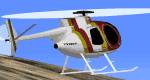
Hughes
500 Cayuse
(Category: FS98 > Helicopters)
0.26Mb (244 downloads)
FS98
Hughes
500 Cayuse with panel. File size 273680. N Bopitiya, M Sanchez
Chico
Posted Jun 23, 2008 14:23 by archive

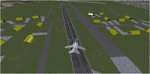
FS2002
BAE Systems Hawk T1A of Virtual Formation Team Canadian Bullets
(Category: FS2002 > Military)
1.16Mb (244 downloads)
FS2002
BAE Systems Hawk T1A of Virtual Formation Team Canadian Bullets.
New Texture Files to re-create XX320. This Hawk, is painted
by Chris Black in the Canadian Bullets Colours. Original by
Mikko Maliniemi and Owen Hewitt. Repaint by Chris Black. 1.2MB
Posted Jun 23, 2008 14:33 by archive