


All Time Popular > Page 5437
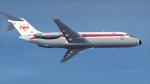
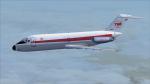
FSX/P3D Sky Simulations DC-9-14 TWA 1967 Textures
(Category: FSX > Payware)
3.28Mb (82 downloads)
This is a repaint of the DC-9-14 in TWA 'Star Stream' Double Globe colors. The payware DC-9-10 by Sky Simulations is needed for this repaint. TWA's first DC-9-14 was delivered new from Douglas in February 1966. They ordered it in 1965 to replace the Lockheed 749A Constellation. The total number of DC-9-10s in the TWA fleet was about 19. They were used primarily on short multistop flights.The fleet was finally sold in the late 1970s for fleet simplification. The textures are 32bit DDS. It was tested on FSX-SE, but should work on FSX & P3Dv3.
Posted Nov 26, 2019 22:42 by Ted Giana
FSX/P3D RealAir Beech Duke Turbine V2 EZDok Camera Set
(Category: FSX > Payware)
0.02Mb (82 downloads)
This EZDok camera set is for the RealAir Beech Duke Turbine V2. There are nine internal cameras and nine external cameras. The cameras were set up to focus on important areas and offer outstanding views. Camera and fuselage shake, dynamic head movement, and splash has
been carefully modified to be as realistic as possible and minimize clipping. Fully compatible with TrackIR. This is just the camera set ready to be imported into EZDok. Aircraft not included.
Posted Nov 26, 2017 05:46 by JackRiordan
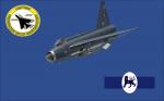
Aerosoft Lightning XR728 Textures
(Category: FSX > Payware)
19.85Mb (82 downloads)
Textures for the payware Aerosoft Lightning representing XR728. She's kept in a live condition and can be found in the hands of the Lightning Preservation Group at Bruntingthorpe. Enjoy.
Posted Apr 15, 2017 10:23 by Cameron Slater

deHavilland DH91 Albatross - SCADTA Columbia Textures
(Category: FS2004 > Vintage)
1.29Mb (82 downloads)
Texture set for the Jens B. Kristensen DH91 Albatross - represents a SCADTA Columbia airliner - historical but fictional repaint of a livery that could have been used for the DH91 if it had continued production and achieve a deserved global usage. Textures by Garry J. Smith-of the Ford Tri-Motor Project.
The aircraft.cfg entry is also included in this download - this repaint is suitable for both the FS2004 and FSX version of the aircraft.
Both FS2004 and FSX Aircraft models are available from http://www.ford-tri-motor.net/Misc-Aircraft.htm Page.
Tri-Motor Project (external link -- report if broken)
Posted Jul 7, 2014 02:02 by Garry J. Smith and Edward C. Moore - Jens B. Kristensen
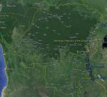
FSX Cong DRC Airfield Locator
(Category: FS Navigation > Flight Simulator Navigation)
2.48Mb (82 downloads)
Tested on Windows XP and Windows 7.
This download adds airfield markers and ICAO id's found in FSX, and overlays them on Google Earth.
This file is for Congo DRC .
There is also a seperate file with a list of basic airfield location details.
i.e: EGBB Birmingham Airport. Birmingham. N52* 27.23' W1* 44.88' alt325.
Also the tidying "My places" in Google Earth, file.
Other locator files to follow.
by Carl Vokes
Posted Aug 14, 2013 14:08 by carl vokes
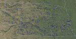
FSX Nebraska Airfield Locator
(Category: FS Navigation > Flight Simulator Navigation)
2.61Mb (82 downloads)
Tested on Windows XP and Windows 7.
This download adds airfield markers and ICAO id's found in FSX, and overlays them on Google Earth.
This file is for Nebraska. USA.
There is also a seperate file with a list of basic airfield location details.
i.e: EGBB Birmingham Airport. Birmingham. N52* 27.23' W1* 44.88' alt325.
Also the tidying "My places" in Google Earth, file.
Other locator files to follow.
by Carl Vokes
Posted Aug 2, 2013 13:46 by carl vokes
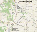
FS2004 Flight Plan for OB-18 Junta Colorado
(Category: FS Navigation > Flight Simulator Navigation)
0.32Mb (82 downloads)
FS2004 Flight Plan for OB-18 Junta Colorado IFR high speed low altitude military training route. This is the seventh in a series of FS2004 flight plans I have uploaded. This route goes through flat and rolling terrain in New Mexico, Texas, Oklahoma, and Colorado. These are great routes for B-52, F-111, B-1B, B-2 A6, A4, Vulcan and any fighter or bomber enthusiasts. Of course you can fly the route with any aircraft of your choice. Included in this package is a gauge by Karol Chlebowski for TFR flying at very low altitude. This gauge will greatly enhance your ability to fly these challenging routes and is a great companion of the flight plans. Another option to download Version 2.0 of my FS2004 mini panel which has all this functionality and more.
Posted Jul 27, 2011 22:21 by Bill McClellan
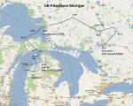
FS2004 Flight Plan for OB-9 Bayshore Michigan
(Category: FS Navigation > Flight Simulator Navigation)
0.45Mb (82 downloads)
FS2004 Flight Plan for OB-9 Bayshore Michigan IFR high speed low altitude military training route. This is the second in a series of flight plans I have uploaded. This route goes through flat and rolling terrain and over water in Ontario and Michigan. These are great routes for B-52, F-111, B-1B, B-2 A6, A4, Vulcan and any fighter or bomber enthusiasts. Of course you can fly the route with any aircraft of your choice. Included in this package is a gauge by Karol Chlebowski for TFR flying at very low altitude. This gauge will greatly enhance your ability to fly these challenging routes and is a great companion of the flight plans. Another option to download Version 2.0 of my FS2004 mini panel which has all this functionality and more.
Posted Jul 27, 2011 22:14 by Bill McClellan
FS98/2000/2002/2004 Beynes Aeronautical Center - France -Thrrmals Scenery
(Category: FS2004 > Gliders and Ultralites)
0.03Mb (82 downloads)
FS98/2000/2002/2004
Beynes Aeronautical Center - France -Thrrmals Scenery These
files adds some thermals to Beynes-Tiverval - Les Mureaux
, located 10 miles East of Paris,France. This airport is home
of Beynes Soaring Association. By Francisco Vargas. 30K
Posted Jun 23, 2008 14:18 by archive
FS2002/2004 Briggs-Fort Worth, Texas, USA Soaring Scenery
(Category: FS2004 > Gliders and Ultralites)
0.07Mb (82 downloads)
FS2002/2004
Briggs-Fort Worth, Texas, USA Soaring Scenery
This file add some thermals to default Microsoft scenery for
Texas Region ,USA,and cover below cities: 1.Briggs: -FLF Airfield(TX23).
-Flying K Airfield(TA27). -JR Ranch Airfield(15FA). 2.Intermediate
cities for distance flights: -Kempner - Worrel Airfield(6TS1).
-Glen Rose - Wright Ranch Airfield(TX93). 3.Fort Worth; -Dallas-Fort
Worth Intl. Airport((KDFW). -Flying Oakes Airfield(2TE2).
-Fuller Airfield((TS00). -Kenneth Copeland Airfield(4TA2).
-Luck Field(F71). -Markun Ranch Airfield(TX79). -Stubbs Strip
Airfield (TS73). 4.Lenticular Clouds: Are pointed at below
cities direction: -Gunnisson City - Gunnisson Airfield (KGUC).
-Buena Vista City - Central Colorado Regl(7V1). -Colorado
Springs City - Rock Mountain Airfield(5CO5). By Francisco
Vargas. 70K
Posted Jun 23, 2008 14:18 by archive