


All Files > Page 1545
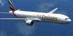
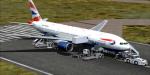
Boeing 777 Mega-Package Vol.3 / 777-300 & 777-300ER
(Category: FSX > Civil Jets)
367.86Mb (30437 downloads)
Project Opensky Volume 3 of the Boeing 777 Mega-Package for Flight Simulator X. It includes the Boeing 777 realistic Virtual Cockpit and Panel from Project Opensky including GPWS, FMC, AutoBrake and several more systems by other authors, 6 Boeing 777 models created by the Project Opensky team (containing the -300 and -300ER variants), Pratt & Whitney PW4090, General Electric GE90-115B and Rolls-Royce Trent 800 sounds created by Luke Hogan, Ismail Zayan and Emil Serafino, 23 High-Quality Liveries divided into the already mentioned variants, custom Aircraft Ground Service (AGS) by P. Opensky, Read-Me file with easy installation instructions and more details about this package. For a more detailed Description, Images, and other great packages at: -fsxluchoals.blogspot.com-
Posted Jan 9, 2013 21:56 by Luis Quintero
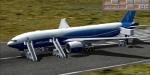
Boeing 777 Mega-Package Vol.2 / 777-200LR & 777-200LRF
(Category: FSX > Civil Jets)
206.11Mb (22974 downloads)
Project Opensky Volume 2 of the Boeing 777 Mega-Package for Flight Simulator X. It includes the Boeing 777 realistic Virtual Cockpit and Panel from Project Opensky including GPWS, FMC, AutoBrake and several more systems by other authors, 2 Boeing 777 models created by the Project Opensky team (containing the -200LR and -200LRF variants), General Electric GE90-115B sounds created by Luke Hogan, 10 High-Quality Liveries divided into the already mentioned variants, custom Aircraft Ground Service (AGS) by P. Opensky, Read-Me file with easy installation instructions and more details about this package. For a more detailed Description, Images, and other great packages at: -fsxluchoals.blogspot.com-
Posted Jan 9, 2013 19:47 by Luis Quintero
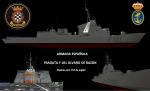
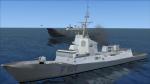
F101 Alvaro de Bazan Frigate AI Ship
(Category: FSX > Misc)
4.97Mb (1401 downloads)
The frigate Alvaro de Bazan is the first of its class, built by the shipyard Izar (now Navantia) for the Spanish Navy. She is active from 2002. It is the first European vessel equipped with Aegis radar, and has served as the basis for the development of the Norwegian Nansen class frigates and the Australian destroyers Hobart class.
Posted Jan 9, 2013 17:18 by jagl04
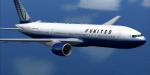
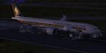
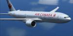
Boeing 777 Mega-Package Vol.1 / 777-200ER
(Category: FSX > Civil Jets)
410.47Mb (29105 downloads)
Project Opensky Volume 1 of the Boeing 777 Mega-Package for Flight Simulator X. It includes the Boeing 777 realistic Virtual Cockpit and Panel from Project Opensky including GPWS, FMC, AutoBrake and several more systems by other authors, 7 Boeing 777-200ER models created by the Project Opensky team, Pratt & Whitney PW4090, General Electric GE90-115B and Rolls-Royce Trent 800 sounds created by Luke Hogan, Ismail Zayan and Emil Serafino, 47 Really Good-Quality Liveries, custom Aircraft Ground Service (AGS) by P. Opensky, Read-Me file with easy installation instructions and more details about this package. For a more detailed Description, Images, and other great packages at: -fsxluchoals.blogspot.com-
Posted Jan 9, 2013 15:31 by Luis Quintero
Skysim Hawk 100 Squadron Texture (front seat only)
(Category: FSX > Payware)
0.61Mb (136 downloads)
This is a repaint for the payware Skysim Hawk T.Mk1 in the colours of XX289 of 100 Squadron, RAF Leeming. Only compatible with Front Seat model. Extra-sharp resolution textures, thanks to DDS and editing techniques.
Posted Jan 9, 2013 15:28 by Michael Russell

Piaggio P-180 Package V3.1 Update
(Category: FSX > Props)
15.94Mb (6435 downloads)
This is a minor update to for the FS-X/P3D version of the P-180 V3.0. It contains optional bugfixes and improvements for:
- Misbehaving clickspots: altitude selector now is only +-100ft, easily operable via mouse wheel.
- Missing Recognition light effect: the file was mistakenly not included in the 3.0 release
- lowered ITTs: for better hot climate behavior; now only very (very) hot days cause problems.
- passenger removed form cabin
- Heading indicator/gyro now automatically synchronizes periodically.
- loading time reduced: CAB gauge is now packed properly
- Autopilot ALT Mode misbehavior: this function now performs as intended.
+ High-resolution cabin & cockpit textures.
FS-X/P3D ONLY edition!! (There is a FS-2004 edition as well)
Required files:
required file
Posted Jan 9, 2013 14:33 by Mario Noriega

Piaggio P-180 Package V3.1 Update
(Category: FS2004 > Props)
5.64Mb (3072 downloads)
This is a minor update to for the FS-2004 version of the P-180 V3.0. It contains optional bugfixes and improvements for:
- Misbehaving clickspots: altitude selector now is only +-100ft, easily operable via mouse wheel.
- Missing Recognition light effect: the file was mistakenly not included in the 3.0 release
- lowered ITTs: for better hot climate behavior; now only very (very) hot days cause problems.
- passenger removed form cabin
- Heading indicator/gyro now automatically synchronizes periodically.
- loading time reduced: CAB gauge is now packed properly
FS-2004 ONLY edition!! (There is a FS-X SP2 edition as well)
Required files:
required file
Posted Jan 9, 2013 14:19 by Mario Noriega
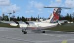

London City Airways Skin-Dash 7 Textures
(Category: FSX > Props)
7.11Mb (1645 downloads)
de Havilland Canada DHC-7|London City Airways G-BOAX texures.
Date: 01/09/2013
Author: Mike Kelley
Livery Description: London City Airways was a former British airline which was founded in 1986 by British Midland to operate services from London City Airport. The company was originally known as Eurocity Express. The airline was closed in 1990 following sustained financial losses.
Required base aircraft - File name: (Dash7PkgX.zip)
Required files:
required file
Posted Jan 9, 2013 12:40 by Milton Shupe

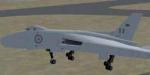
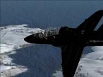
Vulcan B1 Prototype VX777 BETA Model
(Category: FSX > Military)
3.93Mb (1068 downloads)
BETA version: Avro 698 prototype VX777 model only, with default 737-800 panel and sound. Fully working animation and better modeling to represent the original which was quite unique (longer than vx770, different wings, different airbrakes etc from the production B1). This is a big improvement on my earlier version and a great complement to the original prototype vx770. Enjoy, Doug Sleigh
Posted Jan 9, 2013 12:34 by Douglas Sleigh

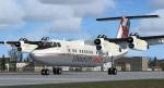
London City Airways-Dash 7 Textures
(Category: FS2004 > Props)
13.53Mb (1349 downloads)
de Havilland Canada DHC-7|London City Airways G-BOAX
textures.
Author: Mike Kelley
Livery Description: London City Airways was a former British airline which was founded in 1986 by British Midland to operate services from London City Airport. The company was originally known as Eurocity Express. The airline was closed in 1990 following sustained financial losses.
Required base aircraft - File name: (Dash7Pkg9.zip)
Required files:
required file
Posted Jan 9, 2013 10:46 by Milton Shupe