


All Files > Page 1675
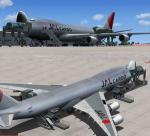
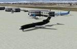
Boeing 747-400FV4 JAL CARGO Package
(Category: FSX > Civil Jets)
25.07Mb (3581 downloads)
Project Opensky - Boeing 747-400FV4 JAL CARGO. Package with ground servicing and a edited default FSX 747 VC and panel.
Project Opensky Freighter 747-400F model. Opening cargo doors. Includes ground services (To operaate go to - Views - Instrument Panel - Posky Utilities).
Thank you to the great talent of the Posky team and the original repainter Ryan C.
Converted to FSX using the Posky native FSX model by Chris Evans.
Posted Jun 18, 2012 08:51 by Chris Evans
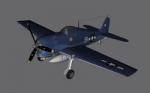
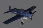
FSX F6F Static Plane Scenery Object
(Category: FS Design > Scenery Design Objects)
0.76Mb (641 downloads)
This is the F6F Hellcat Static plane for FSX. The plane comes in one model (US), it comes in a library and also as a model (MDL). The plane can be put in any scenery by any object placement tool. The F6F is made in GMax by Guy Diotte and the texture also by Guy Diotte.
Posted Jun 17, 2012 23:24 by Guy Diotte
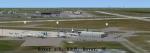
Dover Air Force Base, Delaware
(Category: FSX > Scenery)
49.59Mb (3443 downloads)
Dover Air Force Base package for FSX. Dover AFB is a United States Air Force base located two miles southeast of the city of Dover, Delaware. Dover AFB is home to the 436th Airlift Wing (436 AW) of the Air Mobility Command (AMC), known as the "Eagle Wing", and the AMC-gained 512th Airlift Wing (512 AW) of the Air Force Reserve Command (AFRC), referred to as the "Liberty Wing". It was the only base to solely operate the massive C-5 Galaxy, with two active flying squadrons (the 3rd Airlift Squadron, which now operates the C-17 Globemaster III, and 9th Airlift Squadron) and two Air Force Reserve flying squadrons (the 326th Airlift Squadron and the 709th Airlift Squadron). Just drop and fly. Created to enhance your Flight Sim experience by John B. Loney, Jr.
Posted Jun 17, 2012 12:13 by df
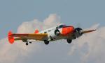
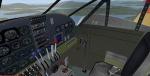
Beechcraft C45G USN Private Package
(Category: FSX > Props)
18.80Mb (3979 downloads)
This is the Simtech Beechcraft C45G N7826L. Privately owned but painted in US Navy livery.
VC (Edited by for FSX Danny Garnier) plus I've taken out the Mip Maps for a
sharper look. Painted by Stephen Browning
Posted Jun 17, 2012 11:16 by Stephen Browning
Geneva Airport, Switzerland
(Category: FS2004 > Scenery)
17.03Mb (2923 downloads)
Geneva Airport, Switzerland.
Improved version of Geneva Airport (LSGG)
For FS2004 only
Adds the three octagonal terminals not originally included, a small cargo facility, terminal lighting, airport facilities and vehicles, and a fire station
Original AFCAD file by Ray Smith ( please see his readme file ), with a few minor changes as necessary.
AFCAD files have been tested for AI aircraft Mike Nicholls
Posted Jun 17, 2012 11:13 by uploader
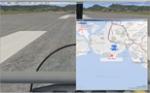
FSX2BMAP Bing Maps Utility
(Category: FSX > Utilities)
0.40Mb (2265 downloads)
FSX utility FSX2BMAP
FSX utility FSX2BMAP version 1.4.0.3. Version 1.4.0.2 is very unstable. Please replace this.
This program shows a your aircraft position on BingMaps. And more flight plan and AI traffic (planes & ships) also is shown.
By Koji Tsubakimoto
Posted Jun 17, 2012 11:02 by Koji Tsubakimoto
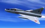
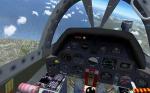
FSX / FS2004 Sud-Est SE-212 Durandal Package
(Category: FSX > Military)
14.05Mb (8987 downloads)
FSX/FS2004 SNCASE SE-212 Durandal, full package, by Patrice Grange. The SNCASE Durandal was a prototype fighter designed and built by the French aircraft manufacturer Sud-Est Aviation (SNCASE) during the fifties. The prototype first flew on 20 April 1956. The Durandal was able to reach a speed of 1667 km/h. However, the program, like a few other ones, was cancelled to the benefit of Dassault Aviation's Mirage III... This is a shame, since it was an amazing aircraft! The model has full moving parts and animations (control surfaces, gears, spoilers, canopy, dragchute, weapons, ladder, ejection, ...) + a custom panel compatible with FS2004 and FSX + a VC. Fully compatible with both FS2004 and FSX (SP2).
Posted Jun 16, 2012 11:31 by Patrice Grange
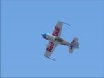
Default Extra 300S FSX - Red Bull White Textures
(Category: FSX > Props)
1.08Mb (758 downloads)
An edited version of the Red Bull Extra 300S, so now you have a white version as well! Textures for the Default 300S in FSX. Made by Edd Norton.
Posted Jun 16, 2012 10:51 by Edd Norton
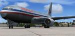
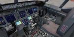
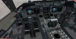
American Airlines Boeing 767-200 Package
(Category: FSX > Civil Jets)
31.61Mb (13103 downloads)
American Airlines SkySpirit2010 767-200 v5. Upgraded to FSX using Alrot's revised
Boeing 737-800 VC. This model includes Working wipers (right mouse click on switch)
with rain effect. Switches for LCD Screens, EICAS, PFD, MFT. Autobrake switch. Opening
pilots window. Cabin Lights switch. Realistic FMC. Ground Proximity Warning System
(GPWS), More Realistic night textures. Model features High resolution textures, Dynamic
flexing wings, Body gear steering, Nose gear steering, Rudder lock, Ground spoilers,
Low speed aileron locks at high speed, Fully animated control surfaces, Fully
independent suspension, Trim Animation, Opening Passenger Doors, Animated tilting
bogies, Rolling wheels, Animated thrust reverser's with reverser block doors, Detailed
textures, Full night lighting, Crash affects, Ground Service Vehicles And more. Model
Designer Hiroshi Igami. Flight Dynamics Designer Warren C. Daniel. Textures by Philip
Foglar. American Airlines repaint by Kyle Schurb.
FSX native model by Skyspirit/Project Opensky. VC by Alejandro Rojas Lucena (Alrot).
Modified for FSX by Chris Evans.
Posted Jun 16, 2012 08:58 by Chris Evans
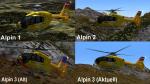
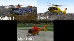
ICARO EC135 Alpin Texture Pack
(Category: FS2004 > Helicopters)
58.44Mb (927 downloads)
Alpin texture-pack for the great ICARO EC135 package. Included are with the liveries of - Alpin 1, Alpin 2, Alpin 3 Alt,
Alpin 3 Aktuell, Gallus 1, Alpin 5 and
Alpin Heli 6. Must have the Icaro EC-135 package.
Required files:
required file
Posted Jun 15, 2012 22:08 by benimix - Benedikt Fröhlich