


All Files > Page 1678
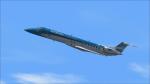
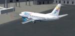
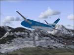
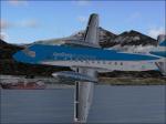
Embraer ERJ 145 Aerolineas Argentinas
(Category: FS2004 > Civil Jets)
18.51Mb (2646 downloads)
Embraer ERJ 145 in Aerolineas Argentinas 2010 scheme. Model by Project Opensky. Textures by Luis Castro
Posted Jun 12, 2012 13:57 by LUIS CASTRO
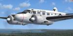
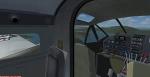
Beechcraft C-45G "Expediter" USAF Package
(Category: FSX > Props)
19.21Mb (9130 downloads)
(Window transparency fixed!) FSX Beechcraft C-45G "Expediter" USAF
A complete redesign by Cliff Presley that converts
simTECH Flight Design's FREEWARE Beech 18 into a
fabulous, photo realistic delineation of a USAF C-45
"Expediter." 500 man hours went into the new textures
and upgraded interior, engine detail, and reconfigured
flight crew. It also includes a sound system by Des
Braban, instrument panel by Fred Choate, and revised
aircraft.cfg file by John de Giorgio that makes this
beauty fly the way she was supposed to. Converted to FSX by Danny Garnier. Textures and panel edits.
Posted Jun 12, 2012 13:22 by Garnier D
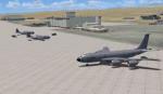
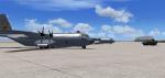
Edwards AFB, California, Ground Additions
(Category: FSX > Scenery)
7.21Mb (5463 downloads)
Edwards AFB, California, Ground Additions
This Scenery Addition is an unofficial Update for the Acceleration Pack Edwards AFB Scenery.
It adds 2 Refuel Stations, Static KC-135 Tanker, Static F-15C, Static A-10, Static Predator, Static C-130 Hercules.
Posted Jun 12, 2012 07:54 by uploader
Isla del Maiz - Corn Island Nicaragua
(Category: FS2004 > Scenery)
0.18Mb (233 downloads)
Beautiful Caribbean island in Nicaragua.
Posted Jun 12, 2012 01:42 by Alberto Thomas
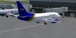
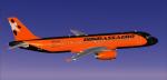
FSX Bahamasair/Xtra Boeing 737-500
(Category: FSX > Civil Jets)
86.32Mb (3647 downloads)
FSX 737-500 new Bahamas Air (C6-BFE) and New Xtra Airlines Bahamasair that has services to KBWI, KRDU, KRIC, KSDF. Painted by BahamasFlyers. Original model by Eric Cantu/FFX adapted for FSX. (No VC.)
Posted Jun 11, 2012 23:26 by Shawn Penn
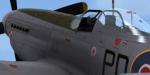
WoP3 P-51D '303' Sqn Textures
(Category: FSX > Payware)
11.94Mb (365 downloads)
This is a repaint for the payware Wings of Power 3 P-51D Mustang by A2A Simulations. The skin depicts personal plane of the last CO of 303 (Polish) Squadron, S/L Witold Lokuciewski. Repaint was done using superb paintkit by Martin Catney (A2A)
Posted Jun 11, 2012 15:17 by Lukasz Kubacki
SAAB 340 Aerolineas Argentinas Textures
(Category: FS2004 > Props)
2.83Mb (487 downloads)
FS2004 Aerolineas Argentinas textures only for the FFG Saab 340. Repaint by Jorge Selandari.
Required files:
required file
Posted Jun 11, 2012 15:00 by Jorge Selandari
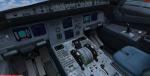
A320 Donbassaero Package
(Category: FSX > Civil Jets)
31.76Mb (1606 downloads)
Project Airbus Donbassaero A320 UR-DAB for FSX. Donbassaero is an airline with its head office in Donetsk International Airport in Donetsk, Ukraine.
Includes default VC, upgraded by Jim Fly and great custom Airbus A320 sounds.
Posted Jun 11, 2012 13:48 by Jim Fly
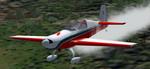
FS2004 Extra-300L SP/HA
(Category: FS2004 > Props)
1.38Mb (743 downloads)
FS2004 Extra-300L SP/HA
The Walter Extra Factory's tandem seater aerobatic plane.
The main gauges builted in the model V.C.
MSFS model designed by Michael Garbers.
Livery, fixed FD mods by George Csillag.
Posted Jun 11, 2012 12:46 by George Csillag
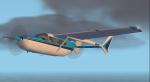
FS2004 Cessna Skymaster Alice Blue Textures
(Category: FS2004 > Props)
0.13Mb (441 downloads)
For use with the C337 by Mike Stone are these textures in a white with two tone blue scheme. These are the textures only, you need sc337.zip to use. Repaint by Don Brynelsen using Mike's paintkit.
Required files:
required file
Posted Jun 11, 2012 12:27 by Don Brynelsen