


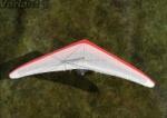
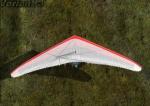
All Files > Page 1677
FSX Alternative Grass Textures
(Category: FSX > Scenery)
4.49Mb (1904 downloads)
FSX Alternative grass textures. To install, copy the detail1.bmp to your FSX SceneryWorldTexture folder. Please ensure you backup your original detail1.bmp file.
Posted Jun 10, 2012 13:37 by uploader
FSX Photoreal Nauru Island
(Category: FSX > Scenery)
17.15Mb (482 downloads)
Comes with complete Photoreal Scenery and Basic Autogen. Also includes a New AFCAD to suit the Photoreal Scenery. Nauru, in the south Pacific NE of Australia, is the world's smallest republic, covering just 21 square kilometres (8.1 sq mi). With just over 9,322 residents, it is the second least-populated country after Vatican City
I have not done any work on the Airport and will leave that for someone else to do.
If you make a New Airport please feel free to include this Scenery with your project and permission is not needed and you may do with this scenery anything you like except make money from it !!
Posted Jun 10, 2012 11:57 by Petro Lambert
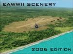
CFS2 East Asia World War II scenery - Full package 2006 edition
(Category: CFS2 > Scenery)
6.78Mb (2473 downloads)
CFS2
East Asia World War II scenery - Full package 2006 edition. New
release of this CFS2 add-on with more than 360 new airfields, seaplane
bases and other sceneries to Combat Flight Simulator 2. By Xavier
Berdaguer. 6.9MB
Posted Jun 10, 2012 11:30 by archive
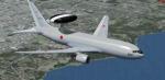
Boeing E-767 Japan Air-Self Defence Force
(Category: FSX > Military)
59.19Mb (11930 downloads)
Japan Air-Self Defence Force Boeing E-767 84-3504.
Upgraded to FSX using Alrot's revised Boeing 737-800 VC. This model includes Working
wipers (right mouse click on switch) with rain effect. Switches for LCD Screens, EICAS,
PFD, MFT. Autobrake switch. Opening pilots window. Cabin Lights switch. Realistic FMC.
Ground Proximity Warning System (GPWS), More Realistic night textures. Model features
High resolution textures, Dynamic flexing wings, Body gear steering, Nose gear
steering, Rudder lock, Ground spoilers, Low speed aileron locks at high speed, Fully
animated control surfaces, Fully independent suspension, Trim Animation, Opening
Passenger Doors, Animated tilting bogies, Rolling wheels, Animated thrust reverser's
with reverser block doors, Detailed textures, Full night lighting, Crash affects,
Ground Service Vehicles And more. Included custom Boeing 767 sounds!
Painted by Yosuke Ube
FSX native model by Skyspirit. VC by Alejandro Rojas Lucena (Alrot).
Modified for FSX by Chris Evans.
Posted Jun 10, 2012 07:09 by Chris Evans

A320 EasyJet Package
(Category: FSX > Civil Jets)
58.73Mb (16084 downloads)
Project Airbus EasyJet A320 G-EZUI for FSX.
Includes upgraded default VC by Jim Fly and great custom Airbus A320 sounds.
Posted Jun 9, 2012 16:55 by Jim Fly
FSX FLRZ Royal Airstrip, Lower Zambezi National Park, Zambia
(Category: FSX > Scenery)
3.46Mb (668 downloads)
FSX FLRZ Royal Airstrip, Lower Zambezi National Park, Zambia. Addition to FSX, No stock airstrip in FSX. For those who like bush flying
Posted Jun 9, 2012 11:32 by Bashir Ismail
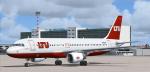
Airbus A320 LTU Package
(Category: FSX > Civil Jets)
57.13Mb (1859 downloads)
Project Airbus LTU A320 D-ALTB for FSX.
Includes default VC, upgraded by Jim Fly and great custom Airbus A320 sounds.
Posted Jun 9, 2012 06:16 by Jim Fly
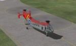
Views for the Piasecki H-21C
(Category: FSX > Helicopters)
0.10Mb (1523 downloads)
Reworked and new views ( defined by camera definitions in the aircraft.cfg file )
for the beautiful Piasecki H-21C. Original model and upgrade by Mick Posch.
6 cameras pointing at the aircraft and a total of 8 views in the 3D cockpit.
See Read me.txt file for very easy installation procedures.
One camera definitions.txt file for all models
And finally two more files - Available.pdf and Top 20.pdf for informations
about my "camera definitions" packages.
Required files:
required file
Posted Jun 8, 2012 23:55 by Marc Renaud
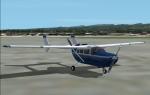
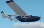
FS2004 Cessna Skymaster Blue Textures
(Category: FS2004 > Props)
0.14Mb (409 downloads)
A repaint of the Cessna 337 by Mike Stone in a white and dark blue scheme. These are the textures only, you will need a copy of Mike's aircraft (sc337.zip) installed to use them. Repaint by Don Brynelsen using Mike's paintkit.
Required files:
required file
Posted Jun 8, 2012 22:21 by Don Brynelsen
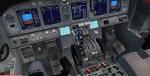
ILS CATII and III Autoland gauges
(Category: FS Gauges > FS Gauges)
0.03Mb (4747 downloads)
This is an ILS CAT II and III autoland gauge for various aircraft.
Aircraft included are 50North & VistaLiners B737 300 400 500, AeroSim L1011, CLS A300 A310 ST (Beluga), CLS DC-10, default A321, default B737-800, default B747-400, PA A318 319 320 321, POSKY B737 600 700 800 900, POSKY B747-400 V3 V4, POSKY B757 - 767, QW B757 (free version), SMS A319-320-321 A330 A340, SMS A380, SMS B737 - 747 - 767 - 777, SMS MD-11, Tom Ruth A330 A340.
Fine tuned for each one.
With or without the autothrust engaged. Includes several options for ILS procedures.
Published with permission from:
Stefan Liebe who is the original author.
Francois Dore who developed it further.
Posted Jun 8, 2012 20:50 by Dimitrios Moschos