


All Files > Page 1674
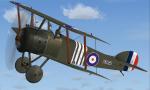
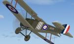
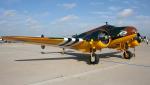
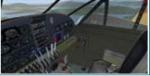
FS2004/FSX Sopwith Camel - Oliver LeBoutillier Textures
(Category: FS2004 > Vintage)
2.76Mb (536 downloads)
Repaint of the David Eckert FS2004 Sopwith Camel. Also works with the W.E. Stephens FSX mod. Captain Oliver “Boots” LeBoutillier was one of the few pilots to witness the downing of the Red Baron, Manfred Von Richtofen. After WWI he enjoyed a small measure of fame as a Hollywood stunt pilot and was also one of Amelia Earhart's flight instructors. Repainted by R.E. Wyman.
Posted Jun 21, 2012 03:08 by R.E. Wyman
Copalis State Airport S16 for Orbx PNW
(Category: FSX > Payware)
10.50Mb (641 downloads)
Copalis State Airport (FAA LID: S16) for Orbx FTX PNW, formerly Copalis Beach State Airport, is located on the beach near Copalis Beach, in Grays Harbor County, Washington, United States. It is the only airport in the United States that is located on an ocean beach.
The runway is the 4,500-foot (1,400 m) stretch of ocean beach from the Copalis River on the south to the rocks a mile north. It is only available during low tide. (from wikipedia) This Addon for FSX requires Orbx PNW (the KHQM demo or the full fledged region )
Posted Jun 21, 2012 01:47 by etien
FS2002/FS2004 SW-190 Space Wolf Space Fighter
(Category: FS2004 > Misc)
1.90Mb (1273 downloads)
FS2002/FS2004 SW-190 Space Wolf.
Science Fiction Animation Plastic Model Series No.36.
This plane is based on the Japanese comic and animation "Space Pirate Captain Herlock".
The SW-190 Space Wolf is a small single seat high speed space fighter, loaded onto the Space Battle Ship "Arcadia".
It was designed on the base of a Focke Wulf FW-190 German fighter aircraft from WW2 and shows many design sensibility.
The Space Wolf has proven to be a very effective weapon against the Mazone fighters.
by Kazunori Ito.
Posted Jun 20, 2012 16:45 by kazito
Beechcraft C45G RAF D-Day Package
(Category: FSX > Props)
19.16Mb (4551 downloads)
This is the Simtech Beechcraft C45G KJ508 Is Privately owned but painted in Royal Air Force D-Day livery. VC (Edited for FSX by Danny Garnier) plus I've taken out the Mip Maps for a sharper look. Painted by Stephen Browning
Posted Jun 20, 2012 16:26 by Stephen Browning
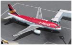
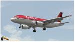
Avianca Airbus A319
(Category: FS2004 > Civil Jets)
9.73Mb (6921 downloads)
Avianca is the flag carrier airline of Colombia.Is the largest airline in Colombia and a major one in Latin America: Avianca together with its subsidiaries has the most extended network of (both passenger and cargo) destinations in the Americas and one of the largest and most modern aircraft fleet in the continent.Photoreal textures in 32 bit format for the freeware Project Airbus A319-115 (model included). Repaint be Manuel Jose. Happy flights.
Posted Jun 20, 2012 15:22 by Manuel Jose Larrahondo Burgos
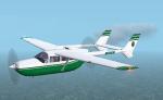
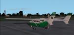
FS2004 Cessna Model 337 Textures (Rosewood)
(Category: FS2004 > Props)
0.23Mb (453 downloads)
Textures for Mike Stone's Skymaster in a white and green livery. Therse are the textures only, you need sc337.zip to use. Repaint by Don Brynelsen using Mike's paintkit.
Required files:
required file
Posted Jun 20, 2012 12:31 by Don Brynelsen
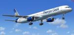

Boeing 757-300 Thomas Cook Package
(Category: FSX > Civil Jets)
69.65Mb (21511 downloads)
Boeing 757-300 painted in the Thomas Cook colors. Textures by Posky team. Model by Project Opensky. Custom B757 sounds. Panel mods for FSX by Sanjay Blair.
Posted Jun 20, 2012 06:44 by Mohd
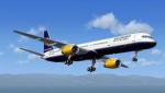
Boeing 757-300 Iceland Air Package
(Category: FSX > Civil Jets)
68.72Mb (10701 downloads)
Boeing 757-300 painted in the IcelandAir colors. Textures by Posky team. Model by Project Opensky. Custom B757 sounds. Panel mods for FSX by Sanjay Blair.
Posted Jun 20, 2012 06:42 by Mohd
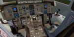
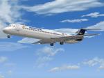
Flight1 Aeropostal McDonnell-Douglas MD-82 (YV134T) Textures
(Category: FS2004 > Payware)
2.59Mb (440 downloads)
McDonnell-Douglas MD-82, (cn 49394/1285), registration number YV134T, when it was in service with the Aeropostal-Alas de Venezuela fleet. Textures only for the Flight One Software CoolSky Super80 Douglas MD-80, (payware package). Flight
Dynamics by Jerry Beckwith, Aircraft Model & Texture by Terry Gaff. Look at
http://www.flight1.com/ for detailed info.
By Juan Ernesto Oropeza.
Posted Jun 20, 2012 03:26 by Juan Ernesto Oropeza
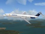
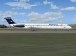
Flight1 Aeropostal McDonnell-Douglas MD-82 (YV133T) Textures
(Category: FS2004 > Payware)
2.60Mb (453 downloads)
McDonnell-Douglas MD-82, (cn 49393/1279), registration number YV133T, when it was in service with the Aeropostal-Alas de Venezuela fleet. Textures only for the payware Flight One Software CoolSky Super80 Douglas MD-80, (payware package). Flight
Dynamics by Jerry Beckwith, Aircraft Model & Texture by Terry Gaff. Look at
http://www.flight1.com/ for detailed info.
By Juan Ernesto Oropeza.
Posted Jun 20, 2012 03:22 by Juan Ernesto Oropeza