


All Files > Page 1682
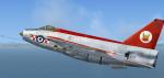
Just Flight Lightning RAF 56 Sqn Textures
(Category: FSX > Payware)
9.93Mb (355 downloads)
RAF Lightning 56 Sqn textures only for the payware Justflight Lightning. By UKMil.
Posted Jun 7, 2012 08:58 by UKMIL
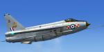
Just Flight Lightning RAF 65 Sqn textures
(Category: FSX > Payware)
9.34Mb (289 downloads)
RAF Lightning 65 Sqn textures only for the payware Justflight Lightning. By UKMil.
Posted Jun 7, 2012 08:45 by UKMIL
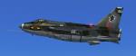
Just Flight Lightning RAF 11 Sqn Textures
(Category: FSX > Payware)
7.51Mb (289 downloads)
RAF Lightning 11 Sqn textures only for the payware Justflight Lightning. By UKMil.
TEXTURES BY ukmil[HTTP://WWW.UKMIL.ORG.UK]
Posted Jun 7, 2012 08:35 by UKMIL
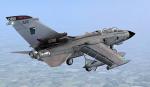
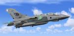
FSX RAF Tornado GR4 617 Sqn Photoreal Textures
(Category: FSX > Military)
3.07Mb (2498 downloads)
FSX Royal Air Force Tornado 617 Sqn photoreal textures
Photoreal textures for 617 SQN RAF Lossiemouth in the UK.
Requires the freeware Tornado by ukmil Textures by ukmil
Required files:
required file
Posted Jun 7, 2012 08:22 by UKMIL
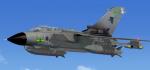
FSX RAF Tornado GR4 2 Sqn Photoreal Textures
(Category: FSX > Military)
3.60Mb (1078 downloads)
FSX Royal Air Force Tornado GR4 2 Sqn Photoreal textures.
Photoreal textures for 2 SQN RAF Marham
Requires the freeware Tornado by ukmil Textures by ukmil
Required files:
required file
Posted Jun 7, 2012 08:17 by UKMIL
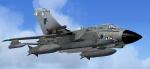
FSX RAF Tornado GR4 9 Sqn Photoreal Textures
(Category: FSX > Military)
2.95Mb (705 downloads)
FSX Royal Air Force Tornado GR4 9 Sqn Photoreal textures.
Photreal textures for 9 SQN RAF Marham
Requires the freeware Tornado by ukmil Textures by ukmil
Required files:
required file
Posted Jun 7, 2012 08:13 by UKMIL
FSX Royal Air Force Tornado GR4 2 Sqn Photoreal Textures
(Category: FSX > Military)
3.05Mb (1033 downloads)
Fsx Royal Air Force Tornado GR4 2 sqn photoreal textures. This pack includes photreal textures for 2 sqn RAF Marham (UK) Requires the freeware Tornado by ukmil Textures by ukmil
Required files:
required file
Posted Jun 7, 2012 08:10 by UKMIL
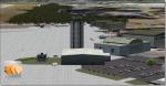
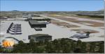
Dobbins AFB, Georgia
(Category: FSX > Scenery)
2.19Mb (1861 downloads)
Dobbins Air Force Base is located in Marietta, GA, United States and is home to a Lockheed-Martin F-22 and C-130 factory. When I saw how many people had downloaded my last version I knew I had to make it better and more detailed. The scenery was created with Airport Design Editor (ADE) and Abacus's Scenery Shortcut program. This is only my second scenery build uploaded to the web and I would like to dedicate this to all our American service men and women; now and throughout history!
Posted Jun 7, 2012 04:55 by Joshua Keaton
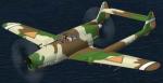
FS2002/FS2004 Fokker D.XXIII.
(Category: FS2004 > Vintage)
3.44Mb (1290 downloads)
FS2002/FS2004 Fokker D.XXIII.
This is a fighter of the Netherlands developed just before World War II.
The layout that arranges two engines before and behind the body is taken.
Though the test was begun in May, 1939,The low output of the engine it, and cooling a back engine became problems.
The Netherlands surrendered by the Netherlands invasion of German army in May, 1940, and development was discontinued.
Only one-plane prototype was destroyed afterwards or is said being confiscated to Germany and having been made to the research material.
by Kazunori Ito.
Posted Jun 6, 2012 15:48 by k ito
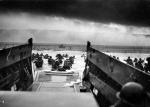
ETO D-Day Part I
(Category: CFS3 > Missions & Campaigns)
6.47Mb (709 downloads)
06-06-1944, 68 years ago! 7 missions for ETO V1.40 or higher. In this mission pack are included two Bostons specially modified to lay a screen of smoke ahead of invasion fleets. Two squadrons were in charge of this mission: 88 and 342 (free French) squadrons.
Posted Jun 6, 2012 15:46 by Led Zeppelin