


All Files > Page 1683
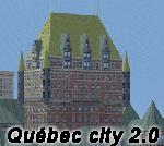
Quebec City v2.00
(Category: FSX > Scenery)
64.77Mb (2464 downloads)
Quebec city version 2.00 for Flight Simulator X.
Quebec city is the capital of the Canadian province of Quebec. Founded in 1608, it's the oldest city in North America. This highly detailed scenery include more than 135 custom buildings built during the past 3 years. Come and see what Quebec City looks likes with it's majors landmarks in your flight simulator. Many new FSX features have been used to build this great scenery like animations and custom special effects. Also, see the CYQB airport scenery by Gilles Boily then enjoy flying in Quebec City.
Posted Jun 6, 2012 11:11 by uploader
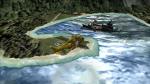
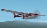
Shetland Isles Search and Rescue Scenery
(Category: FSX > Scenery)
0.24Mb (1015 downloads)
I have made a scenery set up in the Shetland Islands, Scotland, where a fishing boat has ran aground on the north side of the island Foula with two survivors washed up but there are more survivors adrift to
the north east in two orange life rafts and need to be found. Inside the zip file are more instructions and a map to help you find the liferafts.
This is a freeware scenery so it stays that way, the objects are from FSX and FSX Acceleration.
Posted Jun 6, 2012 09:44 by petejg5
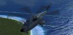
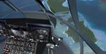
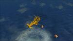
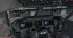
Sud Aviation Super Frelon SA321 Heavy Transport Helicopter Package
(Category: FSX > Helicopters)
57.28Mb (9349 downloads)
FSX/FS2004 Sud Aviation Super Frelon SA321 heavy transport helicopter Package. Full detailed package with doors, virtual cockpit, autohover, checklist and more! By Benoit Dube, Jean-Pierre Langer, Pierre Marchadier, Baptiste Aubertel / Gmax Academy.
Small edits to the FS2004 version to aid the FSX user.
Danny Garnier.
Posted Jun 6, 2012 09:41 by Garnier D
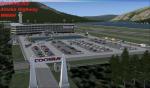
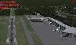
Fictional Alaska Highway Airport
(Category: FSX > Scenery)
1.87Mb (1032 downloads)
This fictional airport is located on the Donjek River along side of an Alaska Highway. I added a few roads so if you have a vehicle in fsx take a drive.
Posted Jun 6, 2012 00:47 by Coosbay323
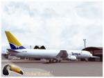
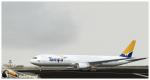
Level D Boeing 767-300 Tampa Cargo Textures
(Category: FS2004 > Payware)
6.72Mb (447 downloads)
Tampa Cargo photoreal textures in 32 bit format for the model payware 767-300 of Level-D. Tampa Cargo, is a cargo airline based at Jose Maria Cordova International Airport. It is a specialized all-cargo airline transporting flowers from Latin America to Miami, as well as general cargo throughout the Americas. Repaint be Manuel Jose Contact Ground. Happy flights.
Posted Jun 5, 2012 18:38 by Manuel Jose Larrahondo Burgos
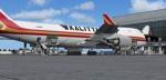
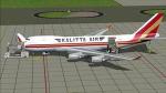
Boeing 747-4HQF (ER) Kalitta Air Package
(Category: FSX > Civil Jets)
25.79Mb (2194 downloads)
Project Opensky - Boeing 747-4HQF (ER) Kalitta Air for fsx. Kalitta Air is an American
cargo airline headquartered in Ypsilanti Township, Michigan, United States. It operates
international scheduled and ad-hoc cargo.
FSX native model features recolored default 747 VC, Ground services. Posky utilities to
enable ground service traffic and stairs. (Find it under Views-Instrument panel - Posky
Utilities). Textures by Mathieu Vos. Upgraded to FSX model by Chris Evans.
Posted Jun 5, 2012 12:30 by Chris Evans
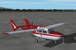
FS2004 Cessna 337 Skymaster Red Textures
(Category: FS2004 > Props)
0.13Mb (745 downloads)
A repaint of Mike Stone's Cessna 337 in a red and white scheme. These are the textures only, you will need a copy of Mike's aircraft (sc337.zip) to use. Repaint by Don Brynelsen using Mike's paintkit.
Required files:
required file
Posted Jun 5, 2012 11:42 by Don Brynelsen
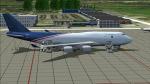
Boeing 747-4HQF (ER) Kalitta Air Cargo
(Category: FS2004 > Civil Jets)
18.39Mb (1508 downloads)
Project Opensky - Boeing 747-4HQF (ER) Kalitta Air. Kalitta Air is an American cargo airline headquartered in Ypsilanti Township, Michigan, United States. It operates international scheduled and ad-hoc cargo. Uses the FS2004 Cargo model by Project Opensky. Textures by Mathieu Vos.
Posted Jun 5, 2012 11:14 by Chris Evans
Boeing 747-400 Saudi Arabian Cargo
(Category: FS2004 > Civil Jets)
18.57Mb (1377 downloads)
Project Opensky - Boeing 747-412F (BDSF) Saudi Arabian Cargo - N743WA. Model by Project Opensky. Textures by Mathieu Vos.
Posted Jun 5, 2012 11:11 by Chris Evans
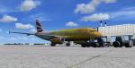
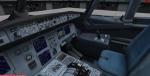
Airbus A319-131 British Airways - The Firefly Olympics Livery with VC
(Category: FSX > Civil Jets)
20.21Mb (4321 downloads)
Project Airbus A319-131 British Airways - The Firefly Olympics Livery with VC
This is British Airways Airbus A319-131 in the Special Olympic Games Colors The Firefly with semi photoreal parts (doors, windows, signs) in 32bit format, dirt version ;)
Model by Project Airbus.
High quality textures by Mathieu Vos
Modified for FSX by Chris Evans.
Posted Jun 5, 2012 11:00 by Chris Evans