


All Files > Page 4373
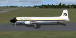
FS2004
Beechcraft BE76 Duchess.
(Category: FS2004 > Props)
1.42Mb (1925 downloads)
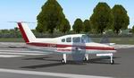
FS2004
Beechcraft BE76 Duchess.
In the Livery of 'Airways Flight Training' - Exeter UK Many
thanks to Matt Laurita. I have effectively used his panel with
one or two very small changes. James Cartner. 1.4MB
Posted Jun 23, 2008 14:25 by archive
FS2004
Aerostar Super 700 - Spirit of Kai Tak
(Category: FS2004 > Props)
0.45Mb (1131 downloads)
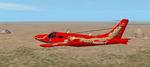
FS2004
Aerostar Super 700 - Spirit of Kai Tak.
The Aerostar Super 700 is the World's fastest piston twin aircraft.
The "Spirit of Kai Tak" competed in and won the London
to Sydney Air Race in March/April 2001. Even though it bore
a USA registration, the team actually was based in Hong Kong
(hence the dragon livery and name!) At times during the race
they were actually recording over 300 knots airspeed! Mark Dickinson.
458K
Posted Jun 23, 2008 14:25 by archive
FS2004
Beechcraft Baron 58 Sky Taxi Airways Textures only
(Category: FS2004 > Props)
0.91Mb (1018 downloads)
FS2004
Beechcraft Baron 58 Sky Taxi Airways Textures only
for the default Baron. Repaint by Joseph H. Ward II. 930K
Posted Jun 23, 2008 14:25 by archive
FS2004
FireDash Package
(Category: FS2004 > Props)
2.16Mb (5023 downloads)
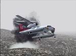
FS2004
FireDash Package
. Features- All animations including Wipers and water rudders.
Water filling gauge and drop pipe. The animation on the gauge
is a little goofy best to let it cycle to empty then shut the
pump off as the Black indicator bar reaches full. Effects file
tied to smoke system. I created a Water drop effect that covers
the fire effects for an hour to give the sense of putting out
the fire. Put as many drops as nessesary to get your desired
result. Modified Forest fire Effect.The forest fire effect has
an additional firebrand effect and is reactive to wind velocities.
California fire placements. The Fire Dash was created for and
during the devastating fires in October of 2007 that tore through
Southern California threatening lives and property. Fire effects
are placed at 4 main areas of the fires near Malibu Lake Arrowhead
and San Diego.Nearest airports (NW of KLAX)(NE of KSEE)(E of
KSDM)(W of L35 past Big Bear Lake) Fly with a visibilty of about
ten miles to help create the effect that the smoke had on the
area.Gmax model and paint by Greg Ebnit. 2.2MB
Posted Jun 23, 2008 14:25 by archive

FS2004
EADS CASA 235-100 Salvamento Maritimo of Spain (Spanish Coast
Guard)
(Category: FS2004 > Props)
7.71Mb (7087 downloads)
FS2004
EADS CASA 235-100 Salvamento Maritimo of Spain (Spanish Coast
Guard).
All usual moving parts, Virtual Cockpit, and two liveries. Panel
by Horst "CloudFlyer" Paetzold. Model, textures and
FDE By J.E.Narcizo & RanchoJEN team. 7.9MB
Posted Jun 23, 2008 14:25 by archive
FS2004/FSX
DC-6B Trans Continental Airlines textures only
(Category: FS2004 > Props)
2.97Mb (1020 downloads)
FS2004/FSX
DC-6B Trans Continental Airlines textures only
Requires the DC-6B by Greg Pepper and Tom Gibson (here).
By Gary Harper. 3MB
Posted Jun 23, 2008 14:25 by archive
FS2004 Cessna 185 Update
(Category: FS2004 > Props)
0.18Mb (1999 downloads)
FS2004
Cessna 185 Update.
This file is an update to the CFG file of the Cessna 185 by
J. R. LUCARINY (here).
This update modifies the contact points of the main gear and
tail wheel. Now the wheels are set at ground level instead of
slightly underneath the ground as seen on the original aircraft.
Also engine horsepower increased to 350hp and stall speed with
flaps down is decreased to 45 knots. This may not sound like
a realistic modification (and it isnt) but hey, its flightsim,
so whatever. The plane now lifts off the ground at a more reasonable
distance, just adjust the prop to 2400rpm at 500ft. no manifold
pressure limit so go wide open until you run out of gas!. I
use a Cessna 206 sound set but you can
alias the default mooney sounds for a more realistic sound.
Have fun with the Cessna 185. 184K
Posted Jun 23, 2008 14:25 by archive
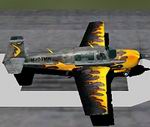
FS2004
Mooney Bravo 'Flames' modified default Mooney
(Category: FS2004 > Props)
7.57Mb (3336 downloads)
FS2004
Mooney Bravo 'Flames' modified default Mooney.
This is the 400 hp beauity you've been waiting for. This bad
boy can cimb the scale at 324 mph with extended altitude and
airshow smoke. Geoffrey M Biteman. 7.7MB
Posted Jun 23, 2008 14:25 by archive
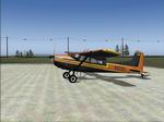
FS2004
Europa XS Tricycle Gear Two-seater tourer
(Category: FS2004 > Props)
2.11Mb (2532 downloads)
FS2004
Europa XS Tricycle Gear Two-seater tourer.
One of the most popular Kit Built Aircraft in the world (over
600 kits sold) with a sparkling performance,long range, good
baggage space,quite aerobatic,quickly and easily dis-assembled,and,to
say the least,very good looking. 2D/3D cockpit. Aircraft and
All by Frank Elton. 2.1MB
Posted Jun 23, 2008 14:25 by archive
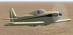
FS2004
KR1 homebuilt
(Category: FS2004 > Props)
0.28Mb (1614 downloads)
FS2004
KR1 homebuilt.
A small, single seat, retractable gear homebuilt, designed by
Ken Rand, using styrofoam/dynel epoxy model aircraft techniques.
By Chris Eve. 290K
Posted Jun 23, 2008 14:25 by archive