


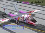
All Files > Page 4375
FS2004
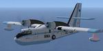
North American CV-10T - "Emily "
(Category: FS2004 > Props)
1.96Mb (2425 downloads)
FS2004
North American CV-10T - "Emily "
Fantastic model by Tim Conrad. Textures by Francis F Silva.
2MB
Posted Jun 23, 2008 14:25 by archive
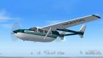
FS2004
Canadair CL215 Multirole amphibious aircraft Package
(Category: FS2004 > Props)
13.35Mb (10885 downloads)
FS2004
Canadair CL215 Multirole amphibious aircraft Package.
The Canadair Cl-215 made its maiden flight on 23 October 1967.
The first delivery was to the French civil protection agency
in June 1969. Production of CL-215s continued through to 1990
with 125 built. This amphibious aircraft serves a number of
roles in a number of countries, ranging from forest fire fighting
to oil spill control on the open sea. Nicknamed the "Waterbomber"
or "Super Scooper," Package includes: Aircraft model
with 3D VC,three set of textures, 2d panel by Massimo Taccoli
FD files by Dennis Seeley Gauges, by Dennis Seeley & Massimo
Taccoli Sound files with permission by Dave Eckert. 13.7MB
Fix.
Update to fix missing glass texture. 10K
Posted Jun 23, 2008 14:25 by archive
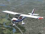
FS2004
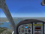
Flight Design CTsw Floats Package.
(Category: FS2004 > Props)
8.82Mb (3404 downloads)
FS2004
Flight Design CTsw Floats Package. The Flight Design CT
is a performance leader in Light Sport Aircraft due to its remarkable
design and high-tech construction. The carbon fiber and Kevlar
composite airframe allows for a very strong, light and aerodynamically
clean design. The unique fuselage design of the CT minimizes
drag and maximizes interior room for you and your luggage. In
production since 1997, more than 900 CTs have been delivered
to customers, worldwide. This is a complete package for FS2004
of aircraft, custom panel, dynamic VC, sounds and documents.
By Barry Blaisdell, Jean-Pierre Brisard, Bob May, Kevin Pardy
and Danny Crance - Premier Aircraft Design. 9MB
Posted Jun 23, 2008 14:25 by archive
FS2004
Flight Design CTsw Wheels Package.
(Category: FS2004 > Props)
8.90Mb (6329 downloads)
FS2004
Flight Design CTsw Wheels Package. The Flight Design CT
is a performance leader in Light Sport Aircraft due to its remarkable
design and high-tech construction. The carbon fiber and Kevlar
composite airframe allows for a very strong, light and aerodynamically
clean design. The unique fuselage design of the CT minimizes
drag and maximizes interior room for you and your luggage. In
production since 1997, more than 900 CTs have been delivered
to customers, worldwide. This is a complete package for FS2004
of aircraft, custom panel, dynamic VC, sounds and documents.
By Barry Blaisdell, Jean-Pierre Brisard, Bob May, Kevin Pardy
and Danny Crance - Premier Aircraft Design. 9.1MB
Posted Jun 23, 2008 14:25 by archive
FS2004
Cessna C-337 Textures only.
(Category: FS2004 > Props)
0.36Mb (1753 downloads)
FS2004
Cessna C-337 Textures only. Purple/Gold
and White/Green. These are repaint textures only for Mike Stones'
Cessna C-337 Skymaster (required here).
Charles Eldridge . 372K
Posted Jun 23, 2008 14:25 by archive
FS2004
Transavia PL-12. "FKF" Textures only
(Category: FS2004 > Props)
0.44Mb (1296 downloads)
FS2004
Transavia PL-12. "FKF" Textures only.
OY-DVZ is still flying at the Dansk Veteranflysamling / Danish
Vintage Aircraft Collection. This is a repaint of the PL-12
AirTruk by Mike Stone (required here).
Repaint by Ugo Vincenzo Boschiero. 454K
Posted Jun 23, 2008 14:25 by archive
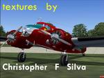
FS2004
Lockheed Electra L-10A Package
(Category: FS2004 > Props)
8.57Mb (5145 downloads)
FS2004
Lockheed Electra L-10A Package -
LPCS Aerodrome Couriers (LPCS Aerodrome.airport). This is an
update (version 2) of the FSDS2/FS2004 Electra L-10 package
from FS-Design Berlin. Textures & repaint by Christopher
F Silva. 8.8MB
Posted Jun 23, 2008 14:25 by archive
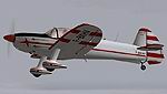
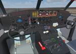
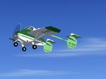
FSX/ FS2004 Mudry CAP-10B Package,
(Category: FS2004 > Props)
3.60Mb (10137 downloads)
FS2004/ FSX
Mudry CAP-10B Package,
a two seater French built aerobatic light airplane. Includes
working virtual cockpit with many advanced features. By Dimitri
Samborski and Nikolai Samsonov / Samdim Design. 3.7MB
Posted Jun 23, 2008 14:25 by archive
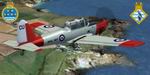
FS2004/FSX De Havilland Chipmunk 771 NAS & HMS Seahawk Station Flight Textures only
(Category: FS2004 > Props)
1.70Mb (2020 downloads)
FS2004/FSX
De Havilland Chipmunk 771 NAS & HMS Seahawk Station Flight
Textures only.
These textures represent DHC Chipmunk WP776 of the HMS Seahawk
(RNAS Culdrose) Station Flight and have been released to celebrate
A) the station's 60th Anniversary (1947-2007); and B) my engagement
nearby at The Lizard! In 1983 WP776 joined 771 NAS, where
it remained until 1992. The inspiration for these textures
was Geoff Wakeham's 2007 book "RNAS Culdrose: 1947-2007"
published by Tempus and highly recommended!Requires the excellent
freeware aircraft by Rick Piper.
Textures are by Andy Ford. 1.7MB
Required files:
required file
Posted Jun 23, 2008 14:25 by archive
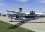
FS2004
Cessna 208B Grand Caravan Zambia Flying Doctor Service
(Category: FS2004 > Props)
4.54Mb (3189 downloads)
FS2004
Cessna 208B Grand Caravan Zambia Flying Doctor Service
This Repaint by Bashir Ismail of the Default FS 2004 Cessna
208B Grand Caravan. ZFDS is the emergency medical wing of the
health care services of the government of Zambia.It was founded
in 1965 by the government to provide emergency medical and health
services to the rural areas of Zambia. Repaint by Bashir Ismail.
4.6MB
Posted Jun 23, 2008 14:25 by archive