


All Time Popular > Page 1715
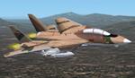
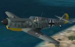
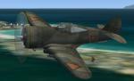
IRIAF
(Islamic Republic of Iran Air Force) F-14A
(Category: FS2002 > Military)
4.36Mb (2062 downloads)
IRIAF
(Islamic Republic of Iran Air Force) F-14A
for fs2000 or 2002,the F-14 has fs2002 version but I can not
make desert texture with the 2002 version, It contained all
player needed, But it have no cockpit because the canopy is
opaque,the original model is not opaque but when I testing
new texture the canopy became opaque, I can not solve this
problem . Original by DINO CATTANEO. 4.4MB
UPDATE
: Fix - fixes transparent window. 96K
Posted Jun 23, 2008 14:33 by archive
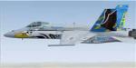
FSX Acceleration F/A-18C Marauders Textures
(Category: FSX > Military)
3.63Mb (2062 downloads)
FSX Acceleration F/A-18C Marauders Textures.
Textures only VFA-82 Marauders
F/A-18C Hornets using Acceleration
default F-18.
Textures only. By Ray Gagnon
Posted Sep 20, 2009 06:16 by admin
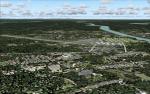
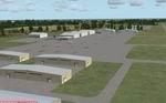
Airports of Maine
(Category: FS2004 > Scenery)
28.47Mb (2062 downloads)
aine Airports
located though out the State of maine. Take off From Augusta State Airport and fly to Bangor or Portand Maine.
To Load into FS 2004 place the files into C:/progam files/microsoft games/flight simulator9/addon scenery/scenery.
Maine Airports is design by Gary L Varnam with the use of EZ-Scenery and AFCAD a5of20@hotmail.com
Includes
Agusta state Airport, Bangor International Airport, Limestone International Airport, Lewiston Aurbun Airport, Bruwick International Airport, Isaboro Island Airport, Camden Maine Airport, Limington Airport. All these airports are improvered. Runways lengthen.
Updated to work with FS 2004. By Gary Varnam This will be my last upload.
Posted Jan 26, 2009 16:38 by Gary L Varnam


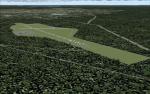
Mermaid Lake of Nepal
(Category: FSX > Missions)
19.55Mb (2061 downloads)
E-Short Story and Adventure Flight.." Max Rex woke up as the far away thunder and wind made the flaps of his bedroom
window slam against the wall. He got up and walked to the window and felt the
humid wind from the coming storm. He looked at his watch noting it was very early,
only 4:55 am. He saw huge cumulus clouds churning as the stormwind pushed them
toward the small city of Bhinga in northern India. Max had come to visit his old friend
Dr. Ernest Wingall Bloom, archaeologist and man of great knowledge."--Read the short story and Join Bella, her father, Dr. Wingal and Max in an adventure into Nepal. The Mermaid lake is said to be cursed but the expedition must go on!!. Experienced bush pilots will find all the clues to find the lake and solve the mystery!!!! Must be able to read maps and navigate by the seat of your pants!!! no easy GPS stuff around the Himalayas...join the expedition and either succed or go bust!!!
Posted Jul 16, 2012 11:43 by Gera Godoy Canova
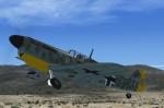
Ha1112 Buchon
(Category: FSX > Vintage)
6.08Mb (2061 downloads)
FS2004-FSX Hispano HA-1112-M1L Buchon
The history of the Spanish built Me-109s and the Hispano Aviacion HA-112-MIL “Buchon”, began in 1936 when the aircraft came into use in the Spanish Civil War. In 1953 there appeared a RR Merlin engined variant. This version, designated HA-1109-M1L, was named Buchon. The HA1112-M1L saw most of its “combat” in the 1970 film, The Battle of Britain that recreated the fierce air battles of 30 years before. After the filming, many Buchon were restored by warbird enthousiast and repainted in the markings of WW2 BF109s.
By A.F.Scrub
Posted Nov 10, 2010 04:23 by A.F.Scrub
FS2004 Beechcraft Model 18 Volpar US Navy Textures only.
(Category: FS2004 > Props)
0.13Mb (2061 downloads)
FS2004
Beechcraft Model 18 Volpar US Navy Textures only.
This is a Navy repaint of the FS9 Beechcraft Model 18 Volpar
by Brian Gladden (required here)
. I did this repaint just for fun, and I wanted to share it
with other simmers File size 1.57. BM Thank to Brian Gladden
for letting me uploading this repaint. 138K
Required files:
required file
Posted Sep 8, 2009 23:28 by archive
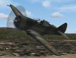
P-36 Dutch
(Category: FSX > Vintage)
5.47Mb (2061 downloads)
FS2004/FSX Curtiss P-36 Dutch:
The Curtiss P-36 Hawk, was an American designed and built fighter aircraft of the 1930s and 40s. It was one of the first of a new generation of combat aircraft, a sleek monoplane design making extensive use of metal in its construction and powered by a powerful radial engine. Obsolete at the onset of World War II and best known as the predecessor of the Curtiss P-40. This is a Dutch version powered by the Cyclone engine. Corrected aircraft.cfg to avoid the model jumping on loading (also works with Finnish version).
GMAX model by A.F.Scrub
Posted Aug 23, 2010 10:26 by A.F.Scrub
Melbourne Florida International Airport (KMLB)
(Category: FSX > Scenery)
0.68Mb (2061 downloads)
Melbourne Florida International Airport (KMLB)
Complete redo of the default FSX Melbourne International Airport (KMLB); surrounding landclass changes; custom FBO model; updated taxiways, aprons and hangers. Also includes library objects and a library of new airport buildings. Assigned gates have been provided for Delta Comair and Delta Airlines flights. By: Art Poole
Posted Apr 18, 2009 04:42 by Art Poole
FSX SPLASH SCREEN Air Jamaica Airbus A340
(Category: Videos/Splashscreens > Splashscreens)
0.68Mb (2061 downloads)
This an FSX splash screen of an Air Jamaica A340 at Norman Manley Intl, Kingston, Jamaica.
Posted Oct 19, 2008 06:23 by Captainwell
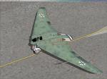
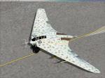
Horten HO229
(Category: FSX > Vintage)
70.22Mb (2060 downloads)
Update FSX Horten HO-229. Static VC, sound, burning effects. 2d panel has been redesigned. All credits for Kazunori Ito. 70.2MB
Posted Aug 26, 2016 15:52 by Rodolfo Valery