


All Time Popular > Page 3604
FS2002
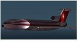
Boeing 727-200 AEROPERU
(Category: FS2002 > Civil Jets)
0.78Mb (685 downloads)
FS2002
Boeing 727-200 AEROPERU. Original by Mike Stone. Repaint
by Alfonso Patron. 807K
Posted Jun 23, 2008 14:33 by archive
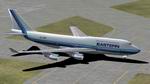
Repaint
textures of FS2002 default Boeing 747_400 in Eastern Airlines
Colors
(Category: FS2002 > Civil Jets)
0.99Mb (685 downloads)
Repaint
textures of FS2002 default Boeing 747_400 in Eastern Airlines
Colors. Easter is no longer in operation, but this is my
rendition of their new paint scheme on the 747. My contact info:
James Daniels. 1MB
Posted Jun 23, 2008 14:33 by archive
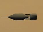
US_40lb_bomb
(Category: CFS2 > Misc)
0.01Mb (685 downloads)
A 40# US bomb that I cobbled together mainly for the A.F. Scrub Cyclone-engined Hawk but they can be used with a number of early WW2 US & allied
aircraft.
Have fun.
Oldwheat
Posted Sep 1, 2010 09:59 by L.M. BROWN
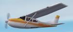
FS2004/2002 Cessna Model 182 RG Textures
(Category: FS2004 > Props)
0.12Mb (685 downloads)
The default Cessna in a Yellow and Orange Scheme. Repaint by Don Brynelsen using the paintkit by Simon Jamie
Posted Jan 15, 2010 12:43 by Don Brynelsen
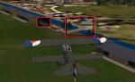
Ockenburg V2
(Category: FS2004 > Scenery)
14.72Mb (685 downloads)
In this file are three updates.
The first change is at the entrance to the airport the light green grass field is gone.
The second change is that the closed borders at the entrance no longer stop at once, but now all well and good.
Unfortunately, I am still not able to be more beautiful than water textures to create for the ditch. These are still future plans.
And the third and largest update is that there is now night textures for the janitorial dwelling.
I would like to thank Cees donker for the grass textures that he has made for me.
I would like to wish you a lot of fun with ockenburg v2 for fs2004 delfault and fs2004 with the golden wings version.
Posted Jan 14, 2010 09:41 by Evert jansen
CFS1 Brussels Scenery
(Category: CFS1 > Scenery)
1.68Mb (685 downloads)
Brussels - Zaventem WWII Scenery for COMBAT FLIGHT SIMULATOR I. Airport original by Edmundo Abad with with additional files for Brussels downtown:
Posted Apr 19, 2009 12:44 by Edmundo Abad
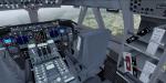
FSX/P3D Boeing 747-400F ASL Airlines package
(Category: FSX > Civil Jets)
80.39Mb (684 downloads)
FSX/P3D Boeing 747-400F ASL Airlines Belgium package. Previously TNT Cargo airlines was purchased by ASL Ireland in 2016. ASL has various Eurpean branches and are expanding rapidly and buying more Boeing 747's.
High quality Project Opensky Boeing 747-400f FSX native model with the much improved Boeing 747 internal model (VC) from Alejandro Rojas Lucenda (Manual included). Model includes ground cargo servicing, stairs (FSX - Go to Views - Instrument Panel -Posky Utility. P3D go to Vehicle - Instrument Panel -).
Added 747 sounds, edited views, panel.
Thank you to Project Opensky/Skyspirit/TDS for their fantastic contribution to the worldwide flight simulation community.
Also includes the Boeing 747 VC textures upgrade. Added wing views.
Textured and assembled for P3D v5 by Chris Evans. Should also work in FSX and previous P3D versions.
Nose
texture fix (if you have
a black square under the nose)
Posted Sep 21, 2021 09:37 by chris evans
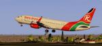
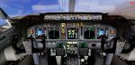
FSX/P3D Boeing 737-800 Kenya Airways package
(Category: FSX > Civil Jets)
63.31Mb (684 downloads)
FSX/P3D Boeing 737-800 Kenya Airways package. Kenya's flag carrier airline is based at Nairobi Jomo Kenyatta International and currently have 8 Boeing 737-800.
TDS high spec. native FSX Boeing 738-800 model. The VC is the FSND modified version of the Microsoft Boeing 738 VC to include various upgrades. Thank you to Alrot fot this.
See Document folder to get the best out of the VC.
Textured, packaged and prepared for FSX & P3D up to v5 by Chris Evans.
Posted Apr 23, 2021 10:40 by chris evans
.jpg-thumb.jpg)
.jpg-thumb.jpg)
FSX/Acceleration/FS2004 Porsche 911 Targa 4s Extension Pack
(Category: FSX > Misc)
27.63Mb (684 downloads)
FSX/Acceleration/FS2004 Extension Pack for Porsche 911 Targa 4s, type 991 from 2014-18 with effect upgrades. The Targa is the model with convertable rooftop which is realisticly and detailed animated. The extension pack comes now in five colours plus new switches and effects. This package includes 2D panels and can be used as replacement for the previous package. The model is easy to repaint because most of the parts are in uni color as glossy alpha channel. The gauges, effects and additional colours are made by J.P. Carosine. The FSDS 3.5 model with VC is made by Erwin Welker.
Posted Mar 17, 2021 04:35 by Erwin Welker
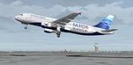
Airbus A320-200 Atlantic Airways.
(Category: FS2004 > Civil Jets)
13.22Mb (684 downloads)
Airbus A320-200 Atlantic Airways. Atlantic Airways is the national airlines of the Faroe Islands, between Scotland and Iceland. Currently Atlantic operate 1 Airbus A320 and 2 A319. Model by Project Airbus and textures by Stephan Bree.
Posted Mar 1, 2017 10:32 by chrisE