


All Time Popular > Page 3679
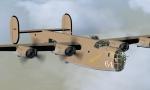
FSX B-24D Lady Be Good
(Category: FSX > Vintage)
10.89Mb (654 downloads)
Repaint of the Alphasim B-24D Liberator. The crew of the "Lady Be Good" became lost in the darkness while returning from a bombing mission over Italy, and tragically flew past her home base in Libya. Believing they were still over the Mediterranean Sea rather than over the Libyan desert, the captain ordered his crew to bail out as the B-24 ran out of fuel. Eight of the nine crewmembers survived the bailout and attempted to hike out of the desert, but none survived the ordeal. The wreckage and remains of all but one of her crew were discovered sixteen years after their disappearance. Freeware Alphasim B-24D aircraft model included. Panel updates and repaint by R.E. Wyman.
Posted May 28, 2025 00:57 by R.E. Wyman
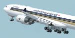
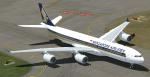
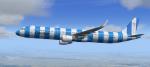
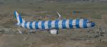
FSX/P3D Singapore Airlines Thomas Ruth A340-500 Texture Pack
(Category: FSX > Civil Jets)
36.56Mb (654 downloads)
Singapore Airlines (9V-SGB: Old Livery, 9V-SGD: New Livery) Textures for the Thomas Ruth A340-500 model. This texture is a part of my project to attempt to re-texture the Thomas Ruth A340s with 4096*4096 HD Textures. Special thanks to Oniel Black for helping with the slats textures. Feel free to join the JetRepaintsSG group on Facebook for more of my repaint works! Installation instructions have been included in the file. Made by Muhammad Akmal Farhan
Required files:
required file
Posted Aug 8, 2023 01:06 by Muhammad Akmal Farhan
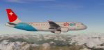
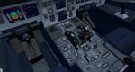
FSX/P3D Airbus A320-200 Chair Airlines package
(Category: FSX > Civil Jets)
86.97Mb (654 downloads)
FSX/P3D Airbus A320-200 Chair Airlines package. Swiss airline Chair is based at Zurich Airport and currently has 2 Airbus A320-200 flying to destinations around Europe and North Africa.
Model by Project Airbus. 2020 updated VC by Speedbird77 with built in FMC by Garret Smith. Includes A320 operation manual and checklist. Airbus sounds included. Textured, assembled for P3D v5.3 by Chris Evans. Should work in FSX and other P3D
Posted Oct 16, 2022 04:30 by chris evans
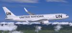
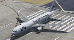
FSX/P3D Boeing 767-300ER United Nations package
(Category: FSX > Civil Jets)
72.72Mb (654 downloads)
FSX/P3D Boeing 767-300ER United Nations package. The United Nations Humanitarian Air Service provides aid to crisis situations around the world. The organisation operates a number of aircraft including this Boeing 767-300ER.
The Skyspirit/Project Opensky FSX native Boeing 767-300 CF6-80C model and paint kit.
Revised night textures, flight dynamics and vc textures. I tried to get the VC textures to be more like the real 767. If you don't like, just swap the 'texture.vc' with those from another aircraft.
Alejandro Rojas Lucena/FSND revised Boeing 737-800 VC model. Added HUD. There are custom Boeing sounds included for that extra realism. Jetways also edited (Ctrl j). Exits, wheel levels and views corrected for FSX/P3d. Boeing 767 checklist included.
Added 767 sounds for more realism. Fixed viewpoints and jetways. Added wing views.
See VC docs to get the best out of the VC and FMC.
Textured, assembled and tested in P3D v5.3 by Chris Evans. Should also work in FSX and earlier P3D versions.
Posted Aug 12, 2022 02:10 by chris evans
FSX/P3D Airbus A321-200 Condor new livery blue D-ATCF package
(Category: FSX > Civil Jets)
76.32Mb (654 downloads)
FSX/P3D Airbus A321-200 Condor new livery blue D-ATCF package. Condor currently operate 10 A321-200 and have a new striped livery.
2020 updated A321 model by Project Airbus updated to FSX native and updated VC by Speedbird77.
Autobrakes fully functional within the vc. Check near the gear lever.
ECAMS lower screen is more accurate. Credit to "FsWorX". Includes A321 checklist. Airbus sounds included. Tested in P3D v5 and should work in FSX and previous P3D versions. Zip preview for images. Textured and packaged by Chris Evans
Posted Apr 23, 2022 12:21 by chris evans
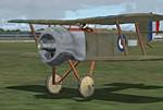
FS2004 Sopwith Bee.
(Category: FS2004 > Vintage)
14.71Mb (654 downloads)
FS2004 Sopwith Bee. Aeroplane Heaven Danish Sopwith Bee package
Posted Mar 24, 2021 12:58 by Aeroplane Heaven
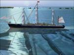
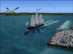
FSX - Tall Ship Bermuda
(Category: FSX > Misc)
3.79Mb (654 downloads)
FSX - Tall Ship Bermuda.
Credits to Ian Thatcher for the Cfg sources and wake effect to compile all the models..thanks so much!!
Visit FSX-Shipyards.com for large collections of freeware ships and boats and submarines..
Don't forget to Copy and Paste the "Effects" into your main Effects Folder.
Updated for FSX by Ewin Sheridan (fsx-shipyards.com).
Ron Jeffers
Posted May 18, 2019 21:18 by Ewin Sheridan
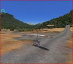
Follow stage 18 of the Tour de France 2017
(Category: FSX > Missions)
0.74Mb (654 downloads)
Watched the Tour de France 2017. Stage 18 looked sort of interesting
as a possible mission, so that is what I've made.
In the actual tour, there are bikes, motorcycles, cars and helicopters used along the route.
A map of stage 18 has been provided. I set out points of interest about 10-15 miles apart.
The route is in the Alps and is 179.5km (111.5 miles, or about 100nm) long.
The final destination is essentially at a mountain top.
Take off in an AirCreation Trike Ultralight from Briancon, to St. Crepin airport to Embrun to Le Sauze du Lac to the airport at Barcelonette to Guillostre and land at the high region of Col d' Izoard. Should you prefer to use a helicopter, feel free to change the trike, say, in the FLT file.
In any case, Touch & Goes at each point of interest and land at Col d'Izoard.
I added crowds at the points of interest. That has required the use of FSX Acceleration or Gold.
Posted Jul 23, 2017 08:35 by Don Olsson
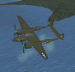
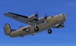
FS2004 / FSX Lockheed P-38L Lightning 'Jeronimo II' - Textures only
(Category: FSX > Vintage)
4.24Mb (654 downloads)
This is a Lockheed P-38L-15-LH Lightning 'Jeronimo II' 80th FS, 459th FG, India 1944. Requires the original DHC P-38
Required files:
required file
Posted Oct 19, 2016 00:30 by Andre Ludick
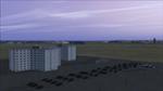
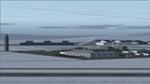
FSX CFB Northstar Scenery (Version 8)
(Category: FSX > Scenery)
19.63Mb (654 downloads)
Located on Banks Island NWT in Canada's arctic, the latest proposed version of CFB North Star scenery (v8) for FSX includes new aurora and obstruction lighting effects, plus additional buildings. Three alternate scenery configurations are provided for, featuring opened hangars, as well as unique library objects that may be used in other freeware scenery projects. Includes flightplans and AI ship traffic (the icebreaker CCGS Louis St-Laurent). FREEWARE by Brian Sturton.
Posted Jul 23, 2015 13:25 by Brian Sturton