


All Time Popular > Page 4396
"A
Tomb in the Clouds, Missions 5 Fix (2)."
(Category: CFS2 > Missions & Campaigns)
0.12Mb (407 downloads)
"A
Tomb in the Clouds, Missions 5 Fix (2)." This repairs the
problems in mission 5 (in the origional and first fix package). You
do not need the any of the prevous releases, this overwrites everything.
Sorry about the problems. Richie Barrett
Posted Jun 10, 2008 11:31 by archive
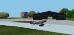
GZR_Debden
Version 1.0
(Category: CFS2 > Scenery)
0.60Mb (407 downloads)
GZR_Debden
Version 1.0 By Richard Charlebois AKA:- "GZR_Frenchy/Frenchy
335th" riqqom@aol.com GZR_Debden is a CFS2 scenery depicting the
home of the 334th,335th and 336th Fighter Squadrons. Since Debden
was not orginally in CFS1 these Historic 4th Fighter Group Squadrons
will now have a base in CFS2. It features three lighted runways
placed in the exact locations of the original. "Dual Start" in free
flight is also installed. This allows a choice of starting from
either the end of the runway or the ramp near the hanger. Refueling
is available. 626K
Posted Jun 10, 2008 11:30 by archive
CFS2
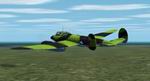
Petlyakov Pe-2 series 31
(Category: CFS2 > Aircraft)
6.25Mb (407 downloads)
CFS2
Petlyakov Pe-2 series 31.
The Petlyakov Pe-2 Peshka Dive Bomber.The fast Soviet dive bomber
derived from the VI-100 high-altitude fighter in 1940. This is the
version that came out in 1941 with the most nose glazing. ENGINES:
Klimov M-105RA 1100hp MAX SPEED: 329mph @ 16500ft CEILING: 28900ft
RANGE: 932mi WEIGHT: 13834lb (MTO 18783) DIMENSIONS: Span 56ft 3 1/2in,
Length 41ft 6 1/2in ARMAMENT: One UB 12.7mm machine gun, three ShKAS
7.62mm machine guns. Petlyakov Pe-2 series 31 for CFS2 Model file,
airfile, DP, panel edit, and textures by Thicko. DP edit and panel
by sandydog. Prop texture by Kelticheart. 6.4MB
Posted Jun 10, 2008 11:31 by archive
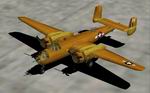
CFS2
B-25 Mitchell Desert Textures only
(Category: CFS2 > Aircraft)
0.74Mb (407 downloads)
CFS2
B-25 Mitchell Desert Textures only!
Fictional livery of B-25 Mitchell in the style of 340th Bomber Group,
African scene 1943. Repaint by Kristel R. Sitz. 757K
Posted Jun 10, 2008 11:31 by archive

Crimea
scenery for CFS1
(Category: CFS1 > Scenery)
1.07Mb (407 downloads)
Crimea
scenery for CFS1. Scenery files, built from USGS DEM data
using CFSClass, for the Crimean Peninsula, the Sea of Azov and their
surroundings, including the region bounded by E30-E40 (Odessa to Rostov)
and N43-N48 (South of Crimea to north of Rostov). Required textures
for summer scenery are included, but winter and fall ones will be
posted separately at this site. Also includes a sample mission describing
an air raid on Odessa on the opening day of Operation Barbarossa.
By C Burgess. 1MB
Posted Jun 10, 2008 11:32 by archive
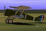
Airco
DH5
(Category: CFS1 > Aircraft)
0.08Mb (407 downloads)
Airco
DH5
for CFS1 The Airco D.H.5 featured an unusual wing configuration, to
improve the pilot's field of vision. You have 2 differently flying
models. The Airco DH5 flies realisticaly and the Airco DH5c (for Combat)
is optimized for multiplayer combat with superb manoeuvrability and
good guns. A.F.Scrub. 84K
Posted Jun 10, 2008 11:32 by archive
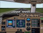
FS2000
Boeing 747-400 panel V2.
(Category: FS2000 > Panels)
(407 downloads)
FS2000
Boeing 747-400 panel V2. New in this version: special throttle/pushback
window, new gauges, cabin signs and i have edit the windowview
because my previous version had some problems. Of course has
this panel also, GPS, Radiostuck, and a compass. This panel
is also fully compatible with VCP2000, Airbus Warning soudns,
GPWS 98/2000, Airport 2000 V2, flightdeck 2000 and startup 98/2000.
And i have also included some winampskins. Configured by Frank
Elfert. 3MB
Posted Jun 23, 2008 14:35 by archive
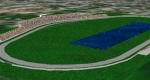
FS98
Scenery--Daytona International Speedway
(Category: FS98 > Scenery)
0.06Mb (407 downloads)
FS98
Scenery--Daytona International Speedway a great scenery
designed for multiplayer nascar races. Includes custom 3D
objects and photo realistic textures. By Daniel Fourquet.
65K
Posted Jun 23, 2008 14:20 by archive
FS98
Netherlands Airports
(Category: FS98 > Scenery)
0.68Mb (407 downloads)
FS98
Netherlands Airports with the Hague, Rotterdam & others
but not Schiphol. File size 717066
Posted Jun 23, 2008 14:20 by archive
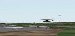
FS2000 Pleiku Airbase. Vietnam, Asia. V2
(Category: FS2000 > Scenery)
2.15Mb (407 downloads)
FS2000
Pleiku Airbase. Vietnam, Asia. V2 Pleiku Airbase is situated
in central Vietnam. At one point between Camp Holloway and Pleiku
itself this area was the busiest airfield in the world. This
version Fixes Helicopter taking off in wrong direction and texture
matches. Pleiku was the first airbase to be hit by enemy forces
which consisted of mortar and rocket attacks. This was the staging
area for many offensive attacks on targets in the north. Aircraft
consisted of fighters, tankers, and cargo planes. Dynamic scenery
includes C-130's, A-4's, A-6's, "Huey's", Sea Kings, and KC135
Tankers. VFR scenery with photo realistic textures surrounds
the airfeild for 32 square miles with tree's, roads, ground
vehicles, and telephone poles. If you have Khe Sanh and Danang
you now have 3 bases to choose from. This scenery requires VOD
textures, ASD textures and APT2.02 textures BY: Owain Robinson.
2.2MB
Posted Jun 23, 2008 14:35 by archive