



All Time Popular > Page 4399


Russia Altai Krai Area Airports
(Category: FS2004 > Scenery)
15.63Mb (410 downloads)
Created airports in the Altai Krai are of Russia. List of airports:
UNBI-Biysk, UNBM-Volchikha, UNBR-Rubtsovsk, UNBW-Petropavlovskoye, UNBZ-Soloneshnoye, XNBJ-Aleysk, XNBK-Kamen'-na-Obi, XNBN-Lesnoy, XNBP-Panfilovo, XNBR-Sibirskiy (Borovikha), XNBS-Slavgorod (Severniy), ZA2B-Charyshskoye, ZAJ8-Slavgorod (Yuzhniy), ZAK0-Shadrino, ZDE1-Ust'-Kalmanka, ZDL7-Burla, ZE0J-Zonalnoye, ZE0L-Tselinnoye, ZE29-Starobelokurikha, ZE47-Kur'ya, ZEC3-Mikhaylovskoye
Posted Oct 26, 2014 17:18 by Andrey Anta


Iris C-27J Reparto Sperimentale Volo Textures
(Category: FSX > Payware)
2.21Mb (410 downloads)
Textures for the payware IRIS C-27J Spartan representing
Aeronautica Militare Italiana "Reparto Sperimentale Volo"
Posted Jun 10, 2014 03:03 by Voyager


FSX Cessna 172 Southampton FC textures
(Category: FSX > Props)
7.18Mb (410 downloads)
Repaint of the default Cessna 172 in colors of the Southampton Football Club Saints. Painted by R.E. Wyman.
Posted Feb 11, 2014 23:29 by R.E. Wyman
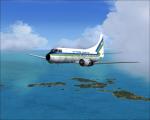
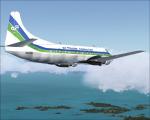
Air Florida Commuter Martin 404 textures
(Category: FS2004 > Vintage)
2.44Mb (410 downloads)
FS9/FSX Air Florida Commuter textures for Martin 404 by Dee Waldron
Requires the model by Dee Waldron. Textures by Gary Harper.
Required files:
required file
Posted Aug 26, 2012 00:52 by Gary Harper
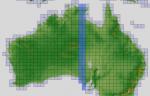
ASTER GDEMv2 30m mesh for Australia Pt10
(Category: FSX > Terrain Mesh)
181.73Mb (410 downloads)
There are Nineteen (19) parts to download for GDEMv2 of Australia.
ASTER GDEM Version 2 is a 30 metre definition DEM, its better than the version 1 data that ERSDAC, of Japan and NASA originally released, but it does have its limitations.
GDEM has been obtained from a satellite that uses stereoscopic infrared scanning cameras, this brings with it problems in the resultant data.....where it sees the tops of trees, buildings etc, as the ground terrain.
If you look at the jpg image with the terrain type errors shown as a graph, you will see that the only 'safe' terrain to use this data with - in FSX - is scrubland, or desert terrain.
Its hopeless in defining the terrain in places like Europe - with all the artificial structures, (buildings) and different types of woodland, so any mesh I create from this data won't include areas like that....it will be more desert type terrain, and scrubland.
I won't be doing Greenland because something about the ice around Greenland, (or any other land mass with ice) it creates false data.
It does give enough fine data to reveal railway lines, and some roads though.
This mesh has been made for FSX only.
Grateful thanks to ERSDAC, and NASA for making this data freely available to the public.
ASTER GDEM
Copyright (c) 2009 - 2011 Earth Remote Sensing Data Analysis Center (ERSDAC) All rights reserved.
ASTER GDEM is a product of METI and NASA.
Posted Jun 2, 2012 03:45 by Wayne Evans
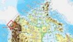
FSX Canadian CDED mesh above 60 degrees Lat 19 metre resolution Pt44, block 115.
(Category: FSX > Terrain Mesh)
158.47Mb (410 downloads)
As Raimondo Taburet hasn't processed the CDED files above 60 degrees latitude for Canada, well here are the ones I have processed.
There isn't any data available from geobase in some of the blocks above 60 degrees latitude, these are blocks: 15, 17, 18, 28, 108, 109, 118, 119.
See jpg for coverage.
Thanks go to Geobase (Copyright) Canada for the availability & public use of this data.
Posted May 19, 2012 09:15 by Wayne Evans

ASTER GDEMv2 30m mesh for Iran & West Caspian Sea states Pt4c
(Category: FSX > Terrain Mesh)
66.77Mb (410 downloads)
There are Fourteen (14) parts of this mesh to download as separate files.
ASTER GDEM Version 2 is a 30 metre definition DEM, its better than the version 1 data that ERSDAC, of Japan and NASA originally released, but it does have its limitations.
GDEM has been obtained from a satellite that uses stereoscopic infrared scanning cameras, this brings with it problems in the resultant data.....where it sees the tops of trees, buildings etc, as the ground terrain.
If you look at the jpg image with the terrain type errors shown as a graph, you will see that the only 'safe' terrain to use this data with - in FSX - is scrubland, or desert terrain.
Its hopeless in defining the terrain in places like Europe - with all the artificial structures, (buildings) and different types of woodland, so any mesh I create from this data won't include areas like that....it will be more desert type terrain, and scrubland.
I won't be doing Greenland because something about the ice around Greenland, (or any other land mass with ice) it creates false data.
It does give enough fine data to reveal railway lines, and some roads though.
This mesh has been made for FSX only.
Grateful thanks to ERSDAC, and NASA for making this data freely available to the public.
ASTER GDEM
Copyright (c) 2009 - 2011 Earth Remote Sensing Data Analysis Center (ERSDAC) All rights reserved.
ASTER GDEM is a product of METI and NASA.
Posted Mar 10, 2012 06:24 by Wayne Evans


Maddog MD-82 JAL Textures
(Category: FS2004 > Payware)
11.52Mb (410 downloads)
JAL Express textures only for the payware Maddog MD-82
Posted Dec 28, 2011 14:51 by Trino Rojas


MStar textures for the Flight 1 Super 727
(Category: FS2004 > Payware)
9.39Mb (410 downloads)
MStar textures for the payware Flight 1 Super 727
Posted Dec 17, 2011 10:07 by Trino Rojas


Phoenix Simulation Grestair Cargo Boeing 757 200f
(Category: FS2004 > Payware)
3.16Mb (410 downloads)
Phoenix Simulation Grestair Cargo Boeing 757 200f textures.
Posted Dec 13, 2011 00:04 by Trino Rojas