


All Time Popular > Page 4402
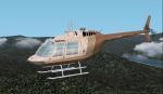
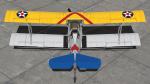
FS2002/2004 Bell Jet Ranger BAS Textures
(Category: FS2004 > Helicopters)
1.35Mb (406 downloads)
Repaint textures for the default Bell 206 in the colors of Bryson Air Services, a charter operation based in Chicago. Repaint by Don Brynelsen using a paintkit by Bob Hayes.
Posted Jun 24, 2010 14:35 by Don Brynelsen
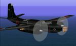
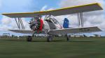
Douglas A-26D Invader Upgrade
(Category: CFS1 > Aircraft)
3.13Mb (406 downloads)
CFS Douglas A-26D Invader Upgrade
Chilean Air Force - Fuerza Aerea de Chile
New version with moving landing gear.
Posted Feb 12, 2010 17:34 by Edmundo Abad
.jpg-thumb.jpg)
.jpg-thumb.jpg)
FSX/Accel Pilotable WWII Leander Class Light Cruiser Ajax
(Category: FSX > Misc)
11.75Mb (405 downloads)
FSX/Accel Pilotable WWII Leander Class Light Cruiser Ajax. HMS Ajax was in service from 1935 to 1948. Now you can explore this warship by toggling through twenty three cameras showing hundreds of realisticly details. Effects are seperatly configured for port and starboard. The Ai-vessel HMS Ajax is converted from the HMS Leander to native FSX using Sketchup by Klaus Novak and belongs to his WWII Royal Navy fleet at SOH. Repainted in camo of 1943, 2D-panel, configurations and files for pilotable vessel by Erwin Welker
Posted Apr 21, 2023 03:28 by Erwin Welker
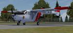
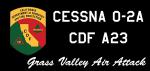
Carenado Cessna 337 (O-2A) CDF Air Attack Pack
(Category: Prepar3d > Payware)
39.23Mb (405 downloads)
I have compiled a pack of CDF Air Attack liveries for the Carenado Cessna 337. You will need the payware for these to work. Tested in FSX and P3D. Total of 10 liveries, A12, 14, 21, 23, 24, 31, 33, 41, 44, 46. Keep your eyes out for the Green flavor, coming soon! Original paint by Rick Bubier.
Posted Nov 22, 2022 03:29 by Delta
FSX/P3D Grumman G-164A Ag Cat VF-6 textures
(Category: FSX > Props)
13.93Mb (405 downloads)
Crop dusting in Style! I felt it was appropriate to paint one Grumman biplane in the likeness of another, so I based this repaint on an F3F-2 that served with VF-6 in the Pre War era. Repaint for the freeware Grumman G-164A Ag Cat by Marcel du Plessis
Required files:
required file
Posted Jun 15, 2022 10:51 by InDeepSchit
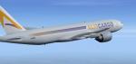
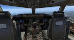
FSX/P3D Boeing 777F AlisCargo package
(Category: FSX > Civil Jets)
88.73Mb (405 downloads)
FSX/P3D
Boeing 777F AlisCargo with updated with re-animated and revised virtual cockpit. AlisCargo is a new Italian cargo airline that started operations in 2021 between Milan and Jinan in China. AlisCargo currently had 3 Boeing 777 Preighter aircraft with plans for more.
Model by Hiroshi Igami, Yosuke Ube with support of Posky members.
Original VC by Jacob Kubique. Converted to FSX native by Zachary777.
VC updates by Speedbird77 with gauges by G. Munro and Ken Wiggington.
See Credits for more.
Textured and assembled for P3d v5 by Chris Evans using the Skyspirit paint kit. Should also work in FSX nd previous P3D.
Posted Feb 23, 2022 12:29 by chris evans

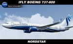
iFly Jets Boeing 737-800 - NordStar
(Category: FSX > Payware)
17.39Mb (405 downloads)
FS9/FSX NordStar textures for the payware iFly Jets Boeing 737-800. Repaint by Sergey Gleba aka serg09. Paint Kit by Denis Minaev. Link to my products on SimMarket: http://secure.simmarket.com/paintsim.mhtml
Posted Aug 2, 2020 13:01 by Sergey Gleba aka serg09
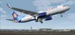
Airbus A320-200 Israir
(Category: FS2004 > Civil Jets)
13.34Mb (405 downloads)
Airbus A320-200 in Israir livery. Model by Project Airbus. Textures by Stefan Bree
Posted Jun 22, 2020 02:44 by chrisE

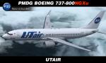
PMDG Boeing 737-800NGX - UTair Textures
(Category: FSX > Payware)
115.43Mb (405 downloads)
PMDG Boeing 737-800NGXu in UTair Aviation old livery. Textures in UHD format only for new PMDG model. Description and installation in Readme file. Repaint by Sergey Gleba aka serg09. Link to my products on SimMarket: http://secure.simmarket.com/paintsim.mhtml
Posted Mar 29, 2020 11:27 by Sergey Gleba aka serg09
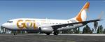
FSX/P3D TDS Boeing 737 Gol Linhas Inteligentes Textures
(Category: FSX > Civil Jets)
17.14Mb (405 downloads)
Textures for the TDS Boeing 737-700. Is the new livery that you can see in the aircraft of the Brazlian Airline the registration is PR-GIH
Required files:
required file
Posted Dec 30, 2019 10:39 by PhotoshopFSX