


All Time Popular > Page 4419

Boeing
747-400 package
(Category: FS98 > Civil Jets)
2.17Mb (400 downloads)
FS98
Boeing
747-400 package. Contains 3 liveries, Cathay Pac, Northwest
& Lufthansa as well as sound & panel. File size 2274376.
Y Cathalina, M Hill
Posted Jun 23, 2008 14:22 by archive
Project
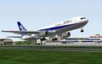
Opensky BOEING 767-300ER All Nippon Airways
(Category: FS2000 > Civil Jets)
1.15Mb (400 downloads)
Project
Opensky BOEING 767-300ER All Nippon Airways 32-sided Fuelage
, Full moving parts Tail-skid , Gears ,jet fan flaps , spoiler
and others ,Night Lighting(landing lights, rotating beacon,
strobes, tail logo) Special 3-D gear-bays ,Transparent cockpit
Animated APU-intake Engine shell inner fairings New base-model
paint textures Flight performance based on a real Euro-airline
767-300ER Designed By Mitsushi Yutaka , Hiroshi Igami Flight
Dynamics by Johan C Dees Tested by Clinton L. Riley ,Franklin
P. Vale, Warren C. Daniel Painted by Hiroshi Igami. 1.2MB
Posted Jun 23, 2008 14:36 by archive
FS2002
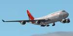
Air India Boeing 747-400.
(Category: FS2002 > Civil Jets)
2.09Mb (400 downloads)
FS2002
Air India Boeing 747-400. This is a repaint of the default
MS 747 in Air India's alternative livery (full aircraft) . photorealistic
textures are used wherever possible. Registration VT-EBX, repainted
by Ricky Sharma. 2.1MB
Posted Jun 23, 2008 14:34 by archive
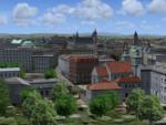
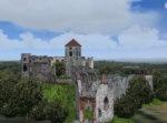
VFR Krakow for EPKK FSX P3D
(Category: FSX > Scenery)
172.47Mb (399 downloads)
The Scenery "VFR Krakow for EPKK FSX&P3D" with an
extended area of the modeled city and with many new objects
and improvmends.
The old capital Krakow in Poland was modeled as an addon scenery
for FSX & P3D. This type of scenery recreates with very
reality a flight over a big city. The EPKK airport is
adjacent to Krakow.
This scenery covers the old part of Krakow with numerous
monuments and historical buildings, as well as the adjacent
districts with their buildings date from different architectural epochs.
Lot of castles and historical objects from the area around
the airport EPKK Balice were also modeled. The scenery included any
animations and moved shipings on the river Vistula (Wisla) and
vehical trafic in the modeled city.
Designer: Lotar Tomczyk, Jakub Mista
Posted Apr 19, 2025 09:09 by Lotar Tomczyk, Jakub Mista

FSX United NC Boeing 787-10 AGS-5G.
(Category: FSX > Civil Jets)
13.16Mb (399 downloads)
FSX United NC Boeing 787-10 AGS-5G.
Night lights reflection on the ground has been added to my moving vehicle headlights and red brake lights in this AGS 5th generation update (Animated Ground Servicing). N.B. Aircraft Taxi Lights must be "on" to see the effect.
Aircraft, panel, ground animations, night effect and paint by Camil Valiquette. ( CamSim )
Posted Jan 27, 2024 02:37 by Camil Valiquette
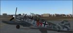
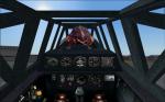
Messerschmitt Bf-109 G-12
(Category: FS2004 > Props)
44.51Mb (399 downloads)
Messerschmitt Bf-109 G-12
two seat trainer version of the Bf 106G fighter.
Switchable rear to front and front to rear 2panels
Posted Jan 9, 2024 09:36 by Michael Vader
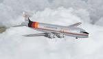
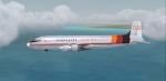
FSX/FS2004 Douglas DC-6A Aerosucre textures
(Category: FSX > Props)
7.67Mb (399 downloads)
FS9/FSX Aerosucre DC-6AB textures for California Classic DC-6A by Greg Pepper and Tom Gibson.
Aerosucre textures by Gary Harper.
Posted Jul 12, 2020 12:18 by Gary Harper

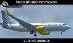
PMDG Boeing 737-700NGX - Vueling Airlines Textures
(Category: FSX > Payware)
18.99Mb (399 downloads)
P3D/FSX Vueling Airlines textures for the payware PMDG Boeing 737-700NGX. Textures in UHD format for PMDG model. Repaint by Sergey Gleba aka serg09. Link to my products on SimMarket: http://secure.simmarket.com/paintsim.mhtml
Posted Mar 14, 2019 11:08 by Sergey Gleba aka serg09
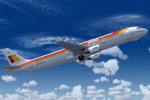
Airbus A321 Iberia
(Category: FS2004 > Civil Jets)
9.44Mb (399 downloads)
Project Airbus A321 model. Features include dynamic wingflex (with input from several new variables), drooping control surfaces, hardcoded double strobes, and over 20 other custom XML parts.
Posted Sep 2, 2018 07:07 by chrisE
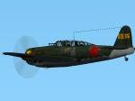
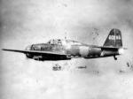
D4Y3 Suisei 601-35 Textures
(Category: CFS2 > Aircraft)
2.18Mb (399 downloads)
Repaint for the superb Thicko's Yokosuka D4Y3 Suisei for CFS2. I used a texture by Morton as a base for this repaint of a "Judy" from 601 Kokutai - Tail number #35.
Required files:
required file
Posted Nov 4, 2016 23:58 by Enrique Godoy