


All Time Popular > Page 4526

FSX/P3D F-35 VMFA122 & 617 RAF Textures
(Category: FSX > Military)
7.65Mb (363 downloads)
These are some more repaints I did of the F-35B from Dino Cattaneo. These liveries are of VMFA211 (Yuma) and RAF 617 Squadron (Marham).
Requires the full F-35 package
Required files:
required file
Posted Jul 25, 2021 04:59 by WVisagie

Update for FSX of the POS Boeing 757-200 no winglets
(Category: FSX > Civil Jets)
20.27Mb (363 downloads)
This is an update for FSX of the Boeing 757-200, no winglets, by Project Open Sky. I have added a HUD to both panels; changed the sound; corrected the contact points; and updated the flight dynamics.
Posted May 25, 2021 01:48 by Bob Chicilo
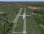
RAF Scorton, UK
(Category: FSX > Scenery)
2.52Mb (363 downloads)
RAF Scorton was opened in October 1939 as part of 13 Group Fighter Command and a satellite station of RAF Catterick. It was located near the village of Scorton in North Yorkshire. It was used by the Royal Air Force, the Royal Canadian Air Force, and the United States Army Air Forces Ninth Air Force during the war. The location was chosen for its flat terrain and its situation close to the now disbanded Eryholme-Richmond branch line that had a sub branch line to Catterick Garrison and RAF Catterick. The famous No. 56 Squadron RAF flew Spitfires from Scorton during the Second World War. Also the USAAF 422d and 425th Night Fighter Squadrons were stationed at Scorton flying the Northrup P-61 "Black Widow" fighter. The Aerodrome closed in 1945 and most of the concreted areas have been extensively quarried away for sand and gravel extraction. Most of what was the airfield is now under a lake or a quarry. There are a few military pre-fab buildings remaining in the area – they were dismantled after the war and moved to local farms to be used as agricultural buildings. Source:Wikipedia
Posted Feb 20, 2017 05:32 by Terry Boissel
Russia-Orenburg region airports
(Category: FS2004 > Scenery)
34.66Mb (363 downloads)
FS2004 Scenery-Russia-Orenburg region
UWOD-Adamovka, UWOE-Sorochinsk, UWOH-Kvarkeno, UWOJ-Dombarovskiy, UWOM-Mednogorsk, UWON-Ponomarevka, UWOP-Pervomayskiy, UWOQ-Sol'-Iletsk (Elshanka), UWOR-Orsk, UWOS-Svetliy, UWOX-Buzuluk, UWOY-Orenburg (Kushkul' Sakmara), XWOA-Ashchibutak, XWOB-Buzuluk, XWOI-Cheben'ki, XWOL-Orsk (Chilizhnyi Dol), XWON-Orenburg-2, XWOR-Orsk (Gudron), XWOS-Sol'-Iletsk, XWOT-Totskoye, XWOW-Orsk (Pervomayskiy), XWTD-Dombarovskiy, ZA02-Abdulino, ZAR0-Terensay, ZC98-Donguz, ZD2F-Orenburg (Pugachi), ZDG7-Verigino, ZDL4-Alimbay
Posted Jan 7, 2016 11:28 by Andrey Anta
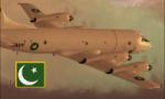
FSX Pakistan Navy P-3 Orion Textures
(Category: FSX > Military)
3.07Mb (363 downloads)
Textures to represent a P-3C Orion Aircraft of the Pakistan Navy based at Karachi. You must have the original aircraft by Team FS KBT. Repaint by Murtaza Akbar.
Required files:
required file
Posted Sep 3, 2015 22:17 by Murtaza Akbar
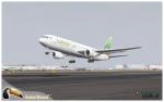
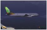
Level D Camair-Co Boeing 767-300 Textures
(Category: FS2004 > Payware)
7.26Mb (363 downloads)
Camair-Co, is an airline from Cameroon. Photoreal textures in 32 bit format for the payware Level-D 767-300 model. Repaint be Manuel Jose, Contact Ground. Happy flights.
Posted Dec 5, 2012 18:14 by Manuel Jose Larrahondo Burgos
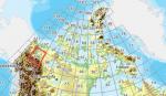
FSX Canadian CDED mesh above 60 degrees Lat 19 metre resolution Pt42, block 106.
(Category: FSX > Terrain Mesh)
212.87Mb (363 downloads)
As Raimondo Taburet hasn't processed the CDED files above 60 degrees latitude for Canada, well here are the ones I have processed.
There isn't any data available from geobase in some of the blocks above 60 degrees latitude, these are blocks: 15, 17, 18, 28, 108, 109, 118, 119.
See jpg for coverage.
Thanks go to Geobase (Copyright) Canada for the availability & public use of this data.
Posted May 19, 2012 08:29 by Wayne Evans
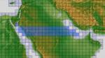
ASTER GDEMv2 30m mesh for Arabian Peninsula Pt2c
(Category: FSX > Terrain Mesh)
72.04Mb (363 downloads)
There are Twenty parts of this mesh to download as separate files.
ASTER GDEM Version 2 is a 30 metre definition DEM, its better than the version 1 data that ERSDAC, of Japan and NASA originally released, but it does have its limitations.
GDEM has been obtained from a satellite that uses stereoscopic infrared scanning cameras, this brings with it problems in the resultant data.....where it sees the tops of trees, buildings etc, as the ground terrain.
If you look at the jpg image with the terrain type errors shown as a graph, you will see that the only 'safe' terrain to use this data with - in FSX - is scrubland, or desert terrain.
Its hopeless in defining the terrain in places like Europe - with all the artificial structures, (buildings) and different types of woodland, so any mesh I create from this data won't include areas like that....it will be more desert type terrain, and scrubland.
I won't be doing Greenland because something about the ice around Greenland, (or any other land mass with ice) it creates false data.
It does give enough fine data to reveal railway lines, and some roads though.
This mesh has been made for FSX only.
Grateful thanks to ERSDAC, and NASA for making this data freely available to the public.
ASTER GDEM
Copyright (c) 2009 - 2011 Earth Remote Sensing Data Analysis Center (ERSDAC) All rights reserved.
ASTER GDEM is a product of METI and NASA.
Posted Mar 7, 2012 11:39 by Wayne Evans


FSX Grumman American AA-5B Tiger repaint N4379W
(Category: FSX > Props)
7.39Mb (363 downloads)
FSX repaint textures N4379W for the Tim Conrad
Grumman American AA-5B Tiger, which you must have
previously installed in FSX. Your choice of 32 bit
2048 pixel textures (for maximum definition),
or 32 bit 1024 pixel textures (for better frame rates).
Install either one, or install both at once if you wish.
Easy installation. Repaint by Tom Tiedman.
Required files:
required file
Posted Nov 18, 2011 20:49 by Tom Tiedman
CFS2
Nakajima B5N2 KATE AKAGI AI-308 Textures only
(Category: CFS2 > Aircraft)
1.74Mb (363 downloads)
CFS2
Nakajima B5N2 KATE AKAGI AI-308 Textures only for The B24 Guy's
Overhaul B5N2 Model.All New "B5N2" Texture and Damage Files
Only.Author: Evan G. Butterbrodt. 1.8MB
Posted Jun 10, 2008 11:31 by archive