


All Time Popular > Page 4525
FS98
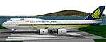
Singapore Airlines Boeing 747-400
(Category: FS98 > Civil Jets)
0.11Mb (364 downloads)
FS98
Singapore Airlines Boeing 747-400. File size 116696
Posted Jun 23, 2008 14:22 by archive
FS
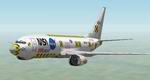
2000, Nasa Boeing 737 - 400
(Category: FS2000 > Civil Jets)
1.85Mb (364 downloads)
FS
2000, Nasa Boeing 737 - 400 IT WILL SHOW UP AS Another 737
- 400, and not the stock FS2000 737 - 400. Uses stock FS2000
panel. 1.9MB
Posted Jun 23, 2008 14:37 by archive
FS2000
Ansett Australia BOEING 747-412
(Category: FS2000 > Civil Jets)
1.25Mb (364 downloads)
FS2000
Ansett Australia BOEING 747-412, registration VH-ANB. Features
48-sided based Variable Sided Fuelage (POSKY Original Technique)
Moving flaperon's, spoileron's, aileron's, elevator's,rudder,
and fan blade's ,Tilting bogie's, gear bay's. (All highly detailed)night
lighting,flashing beacon's. Transparent cockpit windshield with
3-D pilot's. Project OpenSky original repainted by Pranavan
Mahendran. 1.3MB
Posted Jun 23, 2008 14:36 by archive
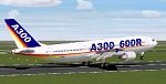
FS2000
- AIRBUS A300-600R
(Category: FS2000 > Civil Jets)
0.32Mb (364 downloads)
FS2000
- AIRBUS A300-600R PW This A300-600R with PW-4158 engine.
transparent cockpit windows, full moving parts, rotation Engine
Fan and turbin Fan, taxi light, auto navigation light, the Landing
light under wing. include FS200 default panel. Aircraft and
texture Designer : Jaefree Lin TW. 333K
Posted Jun 23, 2008 14:36 by archive
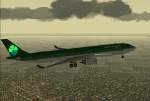
FS2000
Aer Lingus Airbus A330-300
(Category: FS2000 > Civil Jets)
0.09Mb (364 downloads)
FS2000
Aer Lingus Airbus A330-300 (ProMax2001) Same features as
the ProMax2000 (maximum moving parts) Plus a new 3D engine with
rotating fan blades. Also this model is including the lighting-tail
for FS2000. Design and paint by: Camil Valiquette 93K
Posted Jun 23, 2008 14:36 by archive
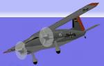
Dornier Do 28D SKYSERVANT - Marineflieger (German Navy)
(Category: CFS1 > Aircraft)
1.24Mb (364 downloads)
CFS/FS98 Dornier Do 28D SKYSERVANT - Marineflieger (German Navy).
The Do 28D-2 was a redesigned Do 28B aircraft with box fuselage, larger wing, new tail and two 380 hp (280 kW) IGSO-540 engines, increased maximum takeoff weight, strengthened fuselage with enlarged cabin, 172 built.
This virtual model represent the Marineflieger Dornier Do 28D-2 # 59+10, Naval Air Wing 5.
Original FS98 model creator: Markus Buensen.
All reworked to CFS1 with new textures, damage profile and moving parts: Edmundo Abad 2010.
Posted May 16, 2010 14:22 by Edmundo Abad
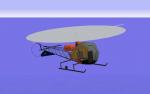
Bell 47D (H-13) Sioux FACH
(Category: CFS1 > Modern Aircraft)
0.84Mb (364 downloads)
Bell 47D (H-13) Sioux for CFS1
Fuerza Aérea de Chile - Chilean Air Force
The Bell 47D (or H-13) was supplied to Chilean Air Force in 1953.
The Chilean Air Force used this helicopters mainly for search and rescue missions, flight training, and liaison.
This Flight Simulator aircraft represents the Bell 47 # H-03 which was operated by the Air Group N° 10, homebased at Cerrillos airbase, in 1970.
Original Aircraft by: Bill Lyons
Adapted to CFS1 with damage profile and repainted by: Edmundo Abad
I have included a damage profile for use with CFS1, with ficcional armament:
2 x 0.30 foward machine guns + 2 x rockets launchers.
Also special thanks to Juan Concha & Roberto Ibarra, former FACH officers, by the great provided information for the development of this virtual model.
Posted Dec 29, 2009 09:02 by Edmundo Abad
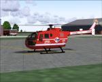
Bo-105 LEGE Textures
(Category: FS2004 > Helicopters)
0.88Mb (364 downloads)
Bo-105 LEGE textures only for the Bo-105 by Guther Krame
Required files:
required file
Posted Aug 3, 2009 06:04 by benimix
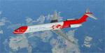
FSX/P3D MD-82 Rwandair Express 3D-ABV livery.
(Category: FSX > Civil Jets)
54.81Mb (363 downloads)
Rwandair Express (Dec 2002 to Mar 2009) / RwandAir ltd [since Mar 2009] operated 3 MD-82. Model by SGA/Eric Cantu.
Full pack with model and livery. Repaint by Norberto Febles.
Posted Mar 19, 2024 20:49 by Norberto Febles
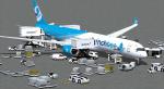
FS2004 French Bee Airbus A350-1000
(Category: FS2004 > Civil Jets)
7.79Mb (363 downloads)
FS2004 French Bee Airbus A350-1000 AGS-4G.
Introducing the latest AGS-4th Generation ( Animated Ground Servicing )
and static display with new features and details, exclusively incorporate with the aircraft model.
High Definition Textures, saved in 32 bits.
Rear cargo lower hold model: Dolly / Container types.
Model design and paint by Camil Valiquette. ( CamSim )
Posted Nov 18, 2022 02:41 by Camil Valiquette