


All Time Popular > Page 4626
FS2004
21 AFCAD2 Files of Western Australian Minesites (Airstrips)
(Category: FS2004 > Scenery)
0.03Mb (334 downloads)
FS2004
21 AFCAD2 Files of Western Australian Minesites (Airstrips)
with
NDB's together with an "Exclude" Folder which contains exclude
and flatten bgl's. Installation instructions are included
Derek Froud. 31K
Fix
for Western Australian Minesites (Airstrips) to correct
a few issues with five of the airstrips.
Readme
update.
Posted Jun 23, 2008 14:25 by archive
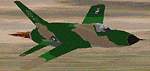
Republic
F-105D Thunderchief,
(Category: FS98 > Military)
0.11Mb (334 downloads)
FS98 Republic
F-105D Thunderchief, based at Dyess AFB. File size 116358.
M Hill, T Hill, M Field
Posted Jun 23, 2008 14:21 by archive
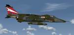
FS2004 RAF Sepecat Jaguar GR1A 54 Sqn Textures only
(Category: FS2004 > Military)
0.70Mb (334 downloads)
FS2004
RAF Sepecat Jaguar GR1A 54 Sqn Textures only.
This pack will give the the Camo colours as applied to the RAF's
Jaguar GR1's it uses the freeware GR1 model from Kaz Ito (required
here). UKMil.
713K
Required files:
required file
Posted Jun 23, 2008 14:28 by archive
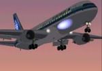
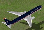
FS2000
Project OpenSky's Boeing 767-300ER
(Category: FS2000 > Civil Jets)
1.01Mb (334 downloads)
FS2000
Project OpenSky's Boeing 767-300ER Highly detailed airliner,
includes animated flaps, slats, spoiler's, rotating fans, rudder,
ailerons and much more. Aircraft by Project Open Sky's. Repaint
into the old Air New Zealand livery by Jon Murchison. 1MB
Posted Jun 23, 2008 14:36 by archive
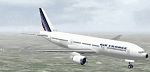
BOEING
777-300 , AIR FRANCE. This is the replacement texture
(Category: FS2000 > Civil Jets)
0.09Mb (334 downloads)
BOEING
777-300 , AIR FRANCE. This is the replacement texture for
the b777-300 from FS2000 Made with the real colors of the Air
FRANCE colors in 24bits To install the texture, replace the
.BMP file in your FS\B777_300\Texture directory (make a bake-up
before) Original Blank texture file By Simon Jamie Repainted
by GERAIN Rémy. 93K
Posted Jun 23, 2008 14:37 by archive
US
Airways Boeing 767-300 for FS2000
(Category: FS2000 > Civil Jets)
0.25Mb (334 downloads)
US
Airways Boeing 767-300 for FS2000 This aircraft has realistic
moving control surfaces, spinning Engine Fans, see through cockpit
glass and the engine nacell moves to the rear when airbrakes
are deployed to simulate reverse thrusters. And the smoke system
to simulate contrails. The panel config file uses the FS2000
default 777-300 and the sound config file uses the default FS2000
737-300 sounds. By William Shedd. 255K
Posted Jun 23, 2008 14:37 by archive
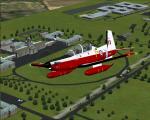
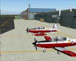
FS2004 Iris T-6A / NTA Texan II - RAF Cranwell Textures V2
(Category: FS2004 > Payware)
4.08Mb (334 downloads)
FS04 T-6A / NTA Texan II - RAF Cranwell Textures V2, Requires the payware Iris T6A.
Repaint by Dave Gore (fooflyer)
Posted Jul 25, 2010 15:05 by Dave Gore fooflyer
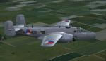
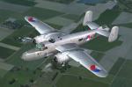
B25J Dutch Air Force M-439 Textures
(Category: FS2004 > Payware)
8.34Mb (334 downloads)
This folder contains a repaint for the MAAM-Sim B-25J 'briefing time', in the colors of an aircraft of the Dutch East Indies Air Force (ML-KNIL). M-439 (44-29032) was a B-25J that flew with the Dutch forces between 1944 and 1950 with No.18 Squadron.It was equipped with a strafer nose, with 8 .50 machine guns. In 1950, it was transferred to the Indonesion Air Force, who used it until 1970. At present, it is in the Indonesian Air Force Museum in Yogjakarta. Repaint by Jan Kees Blom.
Posted Feb 17, 2010 06:31 by Jan Kees Blom
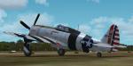
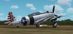
A2A P-47D Textures
(Category: FSX > Payware)
9.95Mb (334 downloads)
This folder contains a repaint for the Shockwave Wings of Power III P-47D Thunderbolt, representing P-47D-23-RA 42-27899, one of the first D23's assigned to the 348th FG. It flown among others by Mike Dikovitsky, who used it to score the last three of his five kills. The last two were claimed in december 1944 in the Phillipines, by which time the 348th had adopted its distinctive black fuselage bands. Repaint by Jan Kees Blom, based on the paintkit by Martin Catney
Posted Feb 15, 2010 15:48 by Jan Kees Blom
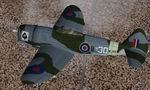
CFS2/FS2004 Alphasim Mk.II Thunderbolt Bubble Top, KJ159/30, 73rd Operational Training Unit RAF, Tex
(Category: FS2004 > Payware)
1.20Mb (334 downloads)
CFS2/FS2004 Alphasim Republic Mk.II Thunderbolt Bubble Top, KJ159/30, 73rd Operational Training Unit RAF, Fayid, Egypt, 1945 Textures only. This repaint is for the ALPHASIM model which can be found at: http://www.alphasim3.com/store/advanced_search_result.php?ke .. Alpha Channel is applied to the fuslage texture file, as to eliminate (make transparent) the stabilizer rib. Repaint by Evan G. Butterbrodt (revev).
Posted Aug 28, 2008 06:41 by Evan G. Butterbrodt