


All Time Popular > Page 4762
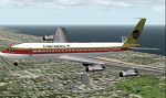
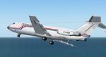
Continental
Boeing 707-320b
(Category: FS2000 > Civil Jets)
0.19Mb (297 downloads)
Continental
Boeing 707-320b - this model features all moving parts.
repainted by Jim Waters. 193K
Posted Jun 23, 2008 14:37 by archive
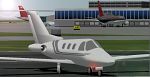
Eclipse
500 For FS 2000
(Category: FS2000 > Civil Jets)
0.77Mb (297 downloads)
Eclipse
500 For FS 2000 Paint, Design, & Animation by: Greggory
Payne I Decided to take advantage of the situation that noone
has even decided to make the Eclipse 500. Yet it is still in
it's production stages, im sure this is somewhat close to what
it will look like. Includes custom panel. 788K
Posted Jun 23, 2008 14:37 by archive
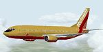
Southwest
737_700
(Category: FS2000 > Civil Jets)
1.48Mb (297 downloads)
Southwest
737_700. Real round body & engines. Model: Sandro Bernardini
(repaint)back panel view introduction: Saulo Júnior. 1.5MB
Posted Jun 23, 2008 14:37 by archive

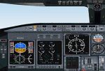
FS2000
CL-65 CRJ200ER Atlantic South East Airlines
(Category: FS2000 > Civil Jets)
0.36Mb (297 downloads)
FS2000
CL-65 CRJ200ER Atlantic South East Airlines This aircraft
has very realistic texures as well as texturized flight deck.
It also has moving flaps, gear, spoilers, landing gear, and
fan blades. The panel is in the general layout of the CRJ, and
uses default FS2000 gauges. Panel/Modifications/Repaint/Dynamics
By: Phillip Robbins Made from Bill Alderson's crjfs2k. 368K
Posted Jun 23, 2008 14:37 by archive

Re-paint
of the default 737 in fictional Canadian Outback Chrome textures
(Category: FS2002 > Civil Jets)
1.27Mb (297 downloads)
Re-paint
of the default 737 in fictional Canadian Outback Chrome textures.
Textures only. By Alexander Urquhart. 1.3MB
Posted Jun 23, 2008 14:33 by archive
FS2004
BAC One-Eleven 432 British Airways leased Textures only
(Category: FS2004 > Civil Jets)
0.61Mb (297 downloads)
FS2004
BAC One-Eleven 432 British Airways leased Textures only.
G-AXOX was leased to British Airways during 1986 in a non standard
Air UK basic but with standard BA titles and standard BA dirt.
Requires the BAC One-Eleven 400HK model by David Maltby\here:
:
Repaint Garry Russell. 621K
Posted Jun 23, 2008 14:28 by archive


FSX/FS2004 McDonnell Douglas MD-11 N272WA Malaysia Airlines
(Category: FSX > Civil Jets)
19.23Mb (296 downloads)
N272WA was built as MSN 48437 and initially, was going to Federal Express as N584FE. Instead she went to World Airways as N272WA in April 1993. During her service with World, she was leased to Aer Lingus four times, Garuda Indonesian three times, Malaysia Airlines twice and Saudi Arabian once. Retired from service in August 2014, N272WA was broken up at Goodyear in 2015.
Painted onto the now freeware SMS Overland MD-11, this repaint shows N272WA as seen in service with Malaysia Airlines in 1995.
Posted Jan 30, 2026 20:01 by Steve Morley
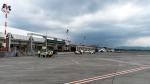
Suroboyo Simulation - Adisucipto - FSX & P3D
(Category: FSX > Scenery)
6.98Mb (296 downloads)
WAHH is an airport located south of Java, near the city of yogyakarta, Adisutjipto Airport is the 4th busiest aort in the region of Java–Bali, after Soekarno Hatta Intl Airport (CGK), Juanda Intl Airport(SUB) and Ngurah Rai Intl Airport (DPS). It has one runway, with dimensions of 2,200 metres (7,200 ft) by 45 metres (148 ft).The number of passengers flying through Adisucipto International Airport in Yogyakarta, throughout 2016 increased by approximately 13 percent compared to 2015. 7.2 million passengers were recorded in 2016 whereas in 2015, the number was 6.38 million. All non-turboprop flights was relocated to The New Yogyakarta Intl Airport (YIA/WAHI) on March 29, 2020 because of The limited availability of land around the airport and overcapacity. Originally made by Suroboyo Simulation for FSX and P3D and was re-uploaded since the website and it's file are no longer existed anymore. By Abdul Hamid.
Posted Jul 26, 2025 08:22 by Abdul Hamid
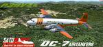
P3Dv4+ Douglas DC-7 Airtanker Pack V2.0
(Category: Prepar3d > Props)
503.64Mb (296 downloads)
This is a significant update and addition to the original DC-7 airtanker pack I released for FSX/P3D. This new version has a number of updates, including PBR, updated sounds, updated 4K textures, and additional new tank models and liveries. The Douglas DC-7s flew in firefighting service from the late 1960s until 2020, where Erickson Aero retired the last 3 firefighting DC-7s. The DC-7s were largely modified by Aero Union in the late 60s and early 70s with a 3,000 gallon retardant/water tank. The DC-7s incredible speed and carrying capability made it a viable tanker for over 40 years. This package holds two model variations representing the DC-7, DC-7B, and DC-7C as they flew as airtankers. There are 10 total repaints representing Erickson Aero, Butler Aviation, T&G Aviation, and Central Air Services. The fantastic original aircraft was created by the crew at Cal Classic Propliners and credit and thanks for their permission to modify and create these iconic variants of the DC-7 belong to Tom Gibson, FSAVIATOR, Jens Kristensen, and Greg Pepper. Airtanker modifications done by Nicholas Mitchell "Scorch00."
Posted May 28, 2023 15:37 by Nicholas Mitchell
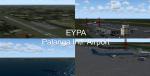
EYPA Palanga Intl Airport Lithuania
(Category: FSX > Scenery)
0.00Mb (296 downloads)
Modification on existing FSX Airport
Improved runway markers and size based on real data.
Several modifications on airport itself, buildings,static planes and surroundings.
Scenery Features:
- 2 Tanker ships
- Airport Vehicles
- Palanga Pier
- Animated people at airport
Posted Aug 13, 2022 11:21 by Kalyan Mukherjee