


All Time Popular > Page 5465
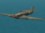
CFS2-Hurricane-Sov
(Category: CFS2 > Aircraft)
8.18Mb (61 downloads)
VERSION 1.1 JULY 2022 (NEW PROPELLER ANIMATION)
Visual model : acwai
Textures: Original paint by unknown author (Shooter). It was modified by me to fit this aircraft. I also
included some VC bitmap from a X-plane Hurricane aircraft (unknown author).
Damage profiles: acwai
Airfile by: acwai, it was tuned to fight against the stock CFS2 Zero aircraft in the multi-player mode.
You can use any Hurricane airfiles.
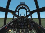
2D panel: The cockpit panel was originally painted by Morton, with permission to modify it.
Special thanks to Martin (Klein) for making the RAF_voltmeter gauge. See readme.txt in the
Panel folder for the authors of the other gauges.
Sound files: Not provided, please download it from sim-outhouse.
DISCLAIMER
Use this program at you own risks, the author is not responsible for any damages done to your computer.
This is a copyrighted freeware program. FREE DISTRIBUTION ONLY. You may upload or post this unmodified aircraft to any web sites. This program can not be posted where a fee of any kind is required or even nagged for. This includes disk distribution or any other kind of fees. It can not be included in a commercial package.
Have fun!
Andrew
Posted Jul 17, 2022 10:35 by Andrew
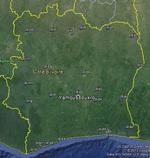
FSX Cote d'lvoire Airfield Locator
(Category: FS Navigation > Flight Simulator Navigation)
2.46Mb (61 downloads)
Tested on Windows XP and Windows 7.
This download adds airfield markers and ICAO id's found in FSX, and overlays them on Google Earth.
This file is for Cote d'lvoire .
There is also a seperate file with a list of basic airfield location details.
i.e: EGBB Birmingham Airport. Birmingham. N52* 27.23' W1* 44.88' alt325.
Also the tidying "My places" in Google Earth, file.
Other locator files to follow.
by Carl Vokes
Posted Aug 24, 2013 14:16 by carl vokes
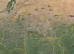
FSX Burkina Faso Airfield Locator
(Category: FS Navigation > Flight Simulator Navigation)
2.51Mb (61 downloads)
Tested on Windows XP and Windows 7.
This download adds airfield markers and ICAO id's found in FSX, and overlays them on Google Earth.
This file is for Burkina Faso.
There is also a seperate file with a list of basic airfield location details.
i.e: EGBB Birmingham Airport. Birmingham. N52* 27.23' W1* 44.88' alt325.
Also the tidying "My places" in Google Earth, file.
Other locator files to follow.
by Carl Vokes
Posted Aug 4, 2013 06:35 by carl vokes
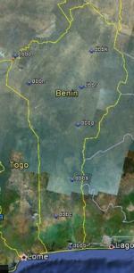
FSX Benin Airfield Locator
(Category: FS Navigation > Flight Simulator Navigation)
2.42Mb (61 downloads)
Tested on Windows XP and Windows 7.
This download adds airfield markers and ICAO id's found in FSX, and overlays them on Google Earth.
This file is for Benin.
There is also a seperate file with a list of basic airfield location details.
i.e: EGBB Birmingham Airport. Birmingham. N52* 27.23' W1* 44.88' alt325.
Also the tidying "My places" in Google Earth, file.
Other locator files to follow.
by Carl Vokes
Posted May 26, 2013 12:05 by carl vokes
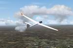
FS2004 Narrogin, Australia, Airfield and Soaring Scenery.
(Category: FS2004 > Gliders and Ultralites)
1.39Mb (61 downloads)
FS2004
Narrogin, Australia, Airfield and Soaring Scenery.
This file adds airfield andthermals lifts to glider´s flights
over Narrogin Region,Australia.It is home of Narrogin Gliding
Club. Design:Francisco Vargas. 1.4MB
Posted Jun 23, 2008 14:18 by archive
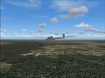
FS2002/2004 Portugal Soaring Scenery.
(Category: FS2004 > Gliders and Ultralites)
0.51Mb (61 downloads)
FS2002/2004
Portugal Soaring Scenery. This
file adds thermals lifts to flights over Portugal Region,
Europe. Design:Francisco Vargas. 522K
Posted Jun 23, 2008 14:18 by archive
FS2002/2004 Alabama,USA Soaring Scenery
(Category: FS2004 > Gliders and Ultralites)
0.24Mb (61 downloads)
FS2002/2004
Alabama,USA Soaring Scenery This
file add some thermals to default Microsoft Scenery for below
cities ,Alabama,USA: 1.Huntsville City - Moontown Airport(3M5)
home of Huntsville Soaring Club. 2.Tuskegee City - Moton Mun
Airport(06A) home of Southern Eagles Soaring. It is freeware.
By Francisco Vargas. 117K
Posted Jun 23, 2008 14:18 by archive
SMS A320 IAE Astra Textures FIX
(Category: FSX > Payware)
0.88Mb (60 downloads)
This is a fix for my Astra Airlines Airbus A320 texture, for Overland SMS Airbus A320 iae model.
It fixes the problem of the livery not showing up at FSX plus a small correction at the logo on the tail fin.
Required files:
required file
Posted Jun 11, 2015 11:01 by Dimitrios Moschos
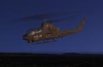
Abacus AH-1G Voodoo Lady 11th ACV Blackhorse Vietnam Textures
(Category: FS2004 > Payware)
3.63Mb (60 downloads)
Voodoo Lady flew with the Air Cavalry Troop, 11th Armored Cavalry Regiment in Vietnam. Textures only for the payware Abacus Premier Collection AH-1G Cobra
Textures only by Lloyd "Snake36Bravo" Goldston
Posted Dec 24, 2013 19:11 by Lloyd "Snake36Bravo" Goldston
FSX Tajikstan Airfield Locator
(Category: FS Navigation > Flight Simulator Navigation)
2.61Mb (60 downloads)
Tested on Windows XP and Windows 7.
This download adds airfield markers and ICAO id's found in FSX, and overlays them on Google Earth.
This file is for Tajikstan .
There is also a seperate file with a list of basic airfield location details.
i.e: EGBB Birmingham Airport. Birmingham. N52* 27.23' W1* 44.88' alt325.
Also the tidying "My places" in Google Earth, file.
Other locator files to follow.
by Carl Vokes
Posted Sep 21, 2013 08:39 by carl vokes