


All Time Popular > Page 919
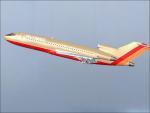
Southwest Airlines 727-100 Textures
(Category: FSX > Civil Jets)
6.53Mb (3858 downloads)
It's no secret to most airline geeks that yes, Southwest did fly something other than the 737. The thing most people don't know is that originally, Southwest never even thought of flying either 727 or 737. Originally, Southwest was supposed to receive Lockheed Electras from American Airlines, but legal trouble allowed the 727 and 737 to become part of Southwest's fleet.
Required files:
required file
Posted Jul 2, 2010 08:41 by Brody C Carlson
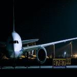
FSX/P3D Boeing 787 (RR) Sound Pack
(Category: FS Sounds > Flight Simulator Sounds)
177.14Mb (3857 downloads)
Trent1000 engine sound pack for the Boeing 787. Includes Gpws and cockpit sounds for Aerosim/QualityWing .
Video: www.youtube.com/watch?v=w4EIByWZ8wA
Posted Jan 13, 2019 01:48 by Kairi Akai
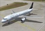
Avianca Star Alliance Airbus A320-214
(Category: FS2004 > Civil Jets)
25.31Mb (3857 downloads)
Project Airbus A320-200 for fs2004 and FSX
Avianca Star Alliance Airbus A320-214 Registration N195AV C/N 5195
Repaint for the Model for Project Airbus A320 v2.1 Model Included.
Posted Nov 10, 2013 14:21 by Carlos Eduardo Salas
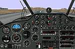
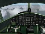
Volpar
Beech 18
(Category: FS98 > Panels)
1.87Mb (3857 downloads)
Volpar
Beech 18, classic plane. File size 1960737. D McGee
Posted Jun 23, 2008 14:21 by archive
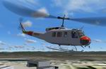
FS2004
Bell 205 Spanish Air Force
(Category: FS2004 > Helicopters)
5.03Mb (3857 downloads)
FS2004
Bell 205 Spanish Air Force Model
by Deane Baunton, Repaint By Jorge GM. 5.1MB
Posted Jun 23, 2008 14:31 by archive
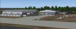
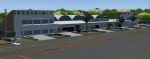
FS2004
Harare & Victoria Falls V1.1
(Category: FS2004 > Scenery)
5.55Mb (3856 downloads)
FS2004
Harare & Victoria Falls V1.1
Airport sceneries for Harare and Victoria Falls in Zimbabwe,
packaged as a complete scenery for the convenience of new
users. Existing users of my V1.0 scenery (removed from Avsim
to avoid confusion) can instead download a patch file to fix
a small texture bug on the roof of the main terminal (see
below). 5.7MB
Zimbabwe
Airports 32 Bit Textures. My 32-bit textures for the airports
of Harare (FVHA) and Victoria Falls (FVFA) above . This archive
contains only the 32-bit format replacement textures for use
with my sceneries for Harare and Victoria Falls that are also
hosted on Simviation. This archive has been made separate
because people using dial-up access shouldn't be forced to
upload gargantuan texture files simply to enjoy a new airport
or two. 9.1MB
Patch:
BGL patch to cure texture problem at Harare Airport A small
patch for Harare & Victoria Falls airport scenery V1.1, until
recently hosted on Avsim. This small BGL file will cure a
texture problem on the main terminal at Harare. It is not
required for the full V1.1 scenery available here on Simviation.com.
This download is recommended for dial-up users and saves you
having to upload almost 5mb of data for a fix of about 40kb.
Created
by Matthew Ministry.
Posted Jun 23, 2008 14:24 by archive
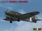
FS2004
Savoia Marchetti S.73 Package ver. 2.0
(Category: FS2004 > Vintage)
21.15Mb (3856 downloads)
FS2004
Savoia Marchetti S.73 Package ver. 2.0
This is the FS9 model of the Savoia Marchetti (SIAI) S73 or
SM73, an elegant thirties Italian transport aircraft. After
a 1.0 version I’ve entirely rebuilt this 2.0. Main upgrades
are: 1) Completely new GMax model(s), with improved details,
animations and texture realism. 2) A new texture map allowing
more flexible repaints. 3) More accurate flight dynamics and
reference notes. 4) Original sound package added. 5) New panel
w/metric gauges. 6) Historical documentation and handling
notes are added. The package contains six texture sets, each
with own model file with four different engine types in flight
dynamics files. The liveries provided are: Ala Littoria (two
liveries), Avio Linee Italiane, Nucleo Comunicazioni LATI,
SABENA and Regia Aeronautica 605-3. Complete package with
model, panel, virtual cockpit, texture sets and sounds. Models,
virtual cockpit, sounds and panel by pcmeneg, paints by Manuele
Villa, flight dynamics, info and handling notes by FSAviator.
See "README_S73_V3.txt", "Handling the S73.txt",
"Navigating the S73.txt" and "History.txt"
for more details. 21MB
Update:
This patch corrects some malfunctions in the VC. Sorry for
the inconvenience. 1.6MB
Posted Jun 23, 2008 14:23 by archive
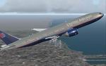
FS2004
Boeing 777-222ER United Airlines Old Colors.
(Category: FS2004 > Civil Jets)
8.74Mb (3856 downloads)
FS2004
Boeing 777-222ER United Airlines Old Colors.
Original my Melvin Rafi (Meljet). Repaint by Tom Ywatt. 8.9MB
Posted Jun 23, 2008 14:30 by archive
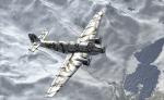
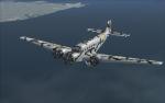
Junkers-52/3M Luftwaffe Winter Camo Texture
(Category: FSX > Vintage)
6.38Mb (3856 downloads)
Winter Camo repaint for the Luftwaffe FSX Junkers Ju-52/3M the outstanding freeware by O.Fischer and updated for FSX by Nor-Cal Prop Club . The model is so awesome and in commercial quality with high amount of attention paid in it's details. This is a repaint for the winter camo used by the German Luftwaffe during WWII.
Required files:
required file
Posted May 29, 2010 22:39 by Hanaw Hax
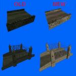
New CFS3 Stock Bridge Textures
(Category: CFS3 > Scenery)
0.55Mb (3856 downloads)
These are new bridge textures to replace the stock CFS3 textures. These will make the stock bridges have a much more realistic color tone.
Posted Jul 27, 2008 12:05 by archive