


All Files > Page 1675
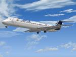
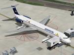
Flight1 Aeropostal McDonnell-Douglas MD-82 (YV134T) Textures
(Category: FS2004 > Payware)
2.59Mb (440 downloads)
McDonnell-Douglas MD-82, (cn 49394/1285), registration number YV134T, when it was in service with the Aeropostal-Alas de Venezuela fleet. Textures only for the Flight One Software CoolSky Super80 Douglas MD-80, (payware package). Flight
Dynamics by Jerry Beckwith, Aircraft Model & Texture by Terry Gaff. Look at
http://www.flight1.com/ for detailed info.
By Juan Ernesto Oropeza.
Posted Jun 20, 2012 03:26 by Juan Ernesto Oropeza
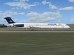
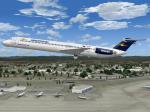
Flight1 Aeropostal McDonnell-Douglas MD-82 (YV133T) Textures
(Category: FS2004 > Payware)
2.60Mb (453 downloads)
McDonnell-Douglas MD-82, (cn 49393/1279), registration number YV133T, when it was in service with the Aeropostal-Alas de Venezuela fleet. Textures only for the payware Flight One Software CoolSky Super80 Douglas MD-80, (payware package). Flight
Dynamics by Jerry Beckwith, Aircraft Model & Texture by Terry Gaff. Look at
http://www.flight1.com/ for detailed info.
By Juan Ernesto Oropeza.
Posted Jun 20, 2012 03:22 by Juan Ernesto Oropeza
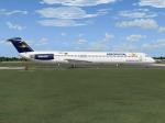
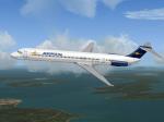
Flight1 Aeropostal McDonnell-Douglas MD-83 (YV131T) Textures
(Category: FS2004 > Payware)
2.35Mb (362 downloads)
McDonnell-Douglas MD-83, (cn 48067/1028), registration number YV131T, when it was in service with the Aeropostal-Alas de Venezuela fleet. Textures only for the payware Flight One Software CoolSky Super80 Douglas MD-80, (payware package). Flight
Dynamics by Jerry Beckwith, Aircraft Model & Texture by Terry Gaff. Look at
http://www.flight1.com/ for detailed info.
Posted Jun 20, 2012 03:00 by Juan Ernesto Oropeza
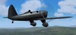
FS2004 Ryan STA Golden Wings
(Category: FS2004 > Vintage)
0.19Mb (613 downloads)
FS2004 Ryan STA Golden Wings
a GW3 AI Plane designed by Bill Lyons.
The AI model's flyable version now with a
aerobatics training Flight Dynamics.
Mods by George Csillag.
Posted Jun 19, 2012 19:53 by George Csillag
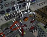
Beech 18 C45 Operations Manual
(Category: FSX > Props)
1.03Mb (1254 downloads)
Operations Manual for the simtech Beech 18/C45 model recently upgraded to be used in FSX. This manual is necessary to properly start the engines after shutdown, etc.
Posted Jun 19, 2012 12:41 by uploader
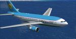
Airbus A310 Multi-Livery Mega-Package
(Category: FSX > Civil Jets)
222.84Mb (24678 downloads)
Done! The Airbus A310 series Multi-Livery Mega-Package is now available! This package contains all the A310 series models, created by Thomas Ruth, custom VIRTUAL COCKPITS and panels for each variant of the A310 (also created by Mr. Ruth), CUSTOM SOUNDPACKS for the GE and the PW engines (created by Mike Maarse), 12 different liveries, a fully edited aircraft.cfg with 27 CUSTOM-MADE VIEWS THROUGHOUT THE ENTIRE AIRCRAFT, and a lot of time and dedication! For more Information of this package, images and a extended explanation in English and Spanish, visit my blog at: http://fsxluchoals.blogspot.com/
Posted Jun 19, 2012 02:56 by Luis Quintero
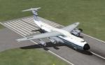
Views for the Lockheed C-5A Galaxy
(Category: FSX > Military)
0.09Mb (2010 downloads)
Views ( defined by camera definitions in the aircraft.cfg file ) for the beautiful Lockheed C-5A Galaxy. Original model by Kazunori Ito.
Unfortunatly there are no VC.
13 cameras pointing at the aircraft, 1 in the cargo bay and a total of 3 views in the virtual cockpit.
See Read me.txt file for very easy installation procedures.
And finally two more files - Available.pdf and Top 20.pdf for informations about my "camera definitions" packages.
Required files:
required file
Posted Jun 19, 2012 02:02 by Marc Renaud
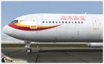
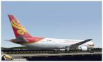
Level D Boeing 767-300 Hainan Airlines Textures
(Category: FS2004 > Payware)
7.04Mb (1929 downloads)
Hainan Airlines photoreal textures in 32 bit format for the payware 767-300 of Level-D. Repaint be Manuel Jose Contact Ground. Happy flights.
Posted Jun 19, 2012 00:42 by Manuel Jose Larrahondo Burgos
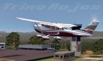

Cerendo C 206 Private texures
(Category: FS2004 > Payware)
3.88Mb (179 downloads)
Cerenado C 206 Private texures for the payaware Carenada C 206
Posted Jun 18, 2012 19:04 by Trino Jose Rojas Mora
Overland SMS Gauges A340 FIX2
(Category: FSX > Payware)
0.00Mb (116 downloads)
This is a fix for v2 of my Overland SMS gauges upgrade pack, and in particular for the A340. It fixes the clock which did not show up in 2d and VC modes.
Required files:
required file
Posted Jun 18, 2012 16:58 by Dimitrios Moschos