


All Time Popular > Page 4427
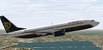
BOEING
737-800 Ryan Air colors (for FS2000)
(Category: FS2000 > Civil Jets)
0.51Mb (393 downloads)
BOEING
737-800 Ryan Air colors (for FS2000) By Sandro Bernardini.
Repaint by Aviel Nahoum. 521K
Posted Jun 23, 2008 14:36 by archive

BOEING
737-400 VIRGIN EXPRESS "blue.com.au"
(Category: FS2000 > Civil Jets)
0.32Mb (393 downloads)
BOEING
737-400 VIRGIN EXPRESS "blue.com.au" for FS2000. Fuselage
and engines are made with a 32 side section which gives them
a real round shape. Featuring animated engines, fullmoving parts,
correctly moving flaps (backwards sliding), Fs2000 style night
lighting, highly detailed and designed wings, full moving gear
doors and turning nose wheel. Original by Sandro Bernardini.
.Paintworks by GERAIN Rémy. 324K
Posted Jun 23, 2008 14:37 by archive
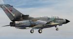
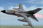
LJLsim Tornado GR1 Royal Air Force XV Sqn Photoreal Textures
(Category: FS2004 > Payware)
7.53Mb (393 downloads)
LJLsim Tornado GR1 Royal Air Force XV Sqn photoreal textures only. Requires the payware Ljlsim Tornado. Textures by Ukmil
Posted May 21, 2010 08:24 by UKMIL
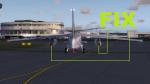
FSX/P3D FIX Native Douglas A3D Skywarrior Revisited
(Category: FSX > Military)
0.32Mb (392 downloads)
I forgot to include one Effect file: fx_engine_Alpha Draken.fx
This file takes care of the Engine Heat effect.
Sorry for my mistake.
Required files:
required file
Posted Jun 15, 2022 08:38 by Flanker256
.jpg-thumb.jpg)
.jpg-thumb.jpg)
FSX/Accel Pilotable WWII Light Cruiser USS Nashville
(Category: FSX > Misc)
11.12Mb (392 downloads)
FSX/Accel Pilotable WWII light cruiser CL43 USS Nashville. The Brooklyn class, buildt between 1935 and 1938, had five 15.2 cm trible guns and four 12.7 cm twin guns fought in the Pacific and Atlantic wars. Powered with 100.000 shp the vessel reached almost 33 knots. Some of the cruisers were sold after WWII to South America. Nashville went after WWII to the chilean Navy as Capitan Prat and was wrecked in 1983. The argentine cruiser ARA General Belgrano (former Phoenix) were sunk during the Falkland War in 1982. Now you can explore this succesful warship by toggling through twenty five cameras showing hundreds of realisticly details. Effects are seperatly configured for port and starboard. The Ai-vessel USS Helena is converted from Sketchup to native FSX by Klaus Novak and belongs to his WWII US Navy fleet at SOH. Repaint for the Nashville in 1962 Atlantic camo, 2D-panel, configurations and files for pilotable vessel by Erwin Welker
Posted Apr 18, 2022 15:02 by Erwin Welker
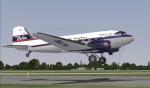
FSX/P3D Douglas DC-3 Delta Air Freighter textures
(Category: FSX > Vintage)
42.67Mb (392 downloads)
FSX Delta DC-3 Air Freighter textures for Manfred Jahn and team C-47 v3.12.
Delta Air Lines textures by Gary Harper.
Required files:
required file
Posted Mar 24, 2019 09:14 by Gary Harper
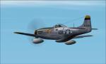
P51 Captmercy
(Category: CFS2 > Aircraft)
31.83Mb (392 downloads)
Morton's mod to the Alphasim P51 I removed 2d cockpit rearranged flight instruments in VC and remade F5 and F9 windows to my keep it simple format also re-did flight model, and air file a bit.
Posted Jul 29, 2017 02:11 by Peter Mercy
ASTER GDEMv2 30m mesh for Sudan & the Horn of Africa pt11
(Category: FSX > Terrain Mesh)
171.38Mb (392 downloads)
There are Eleven (11) parts of this mesh to download as separate files.
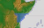
ASTER GDEM Version 2 is a 30 metre definition DEM, its better than the version 1 data that ERSDAC, of Japan and NASA originally released, but it does have its limitations.
GDEM has been obtained from a satellite that uses stereoscopic infrared scanning cameras, this brings with it problems in the resultant data.....where it sees the tops of trees, buildings etc, as the ground terrain.
If you look at the jpg image with the terrain type errors shown as a graph, you will see that the only 'safe' terrain to use this data with - in FSX - is scrubland, or desert terrain.
Its hopeless in defining the terrain in places like Europe - with all the artificial structures, (buildings) and different types of woodland, so any mesh I create from this data won't include areas like that....it will be more desert type terrain, and scrubland.
I won't be doing Greenland because something about the ice around Greenland, (or any other land mass with ice) it creates false data.
It does give enough fine data to reveal railway lines, and some roads though.
This mesh has been made for FSX only.
Grateful thanks to ERSDAC, and NASA for making this data freely available to the public.
ASTER GDEM
Copyright (c) 2009 - 2011 Earth Remote Sensing Data Analysis Center (ERSDAC) All rights reserved.
ASTER GDEM is a product of METI and NASA.
Posted Mar 18, 2012 06:38 by Wayne Evans
FS2002/2004 Dixie Belle PA28
(Category: FS2004 > Props)
1.05Mb (392 downloads)
The South has risen again! These are repaint textures for use with the default Cherokee-180. Optional alternative textures are also included if you don't care for the Stars and Bars on the wings and fuselage. Repaint by Don Brynelsen
Posted Oct 12, 2011 15:16 by Don Brynelsen
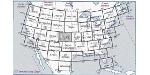
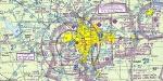
Real Charts VFR Sectionals: San Francisco
(Category: FS Navigation > Flight Simulator Navigation)
24.07Mb (392 downloads)
Hi-def scans of real VFR aeronautical United States charts, as available for download from the FAA, reduced
and formatted in pdf form by me for use with flight sims. Display them in a kneeboard utility,print them,
whatever...I like to use fragments of them to make pdfs for different flights, but that is only one way.
If you want to "get real" about navigating in the sim the way it's done in real life, these charts are for
you. But you might also just enjoy wandering around, comparing the chart to the world depicted in the sim.
These charts will most likely be outdated by the time you use them, or your sim may even pre-date the charts,
but they should work well enough.
A basic guide for interpreting them is included, as well as tips on how to measure and mark them. Each chart
also includes a handy chart legend, a map showing what region it covers, and airspace and frequency
information.
If you are unfamiliar with how to use them for navigation, be sure to check out my multi-part tutorial
series "Compass, Clock, and Chart", available here at simviation.com.
Posted May 4, 2011 22:24 by Sean Morrissey