


All Time Popular > Page 1742
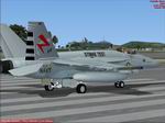
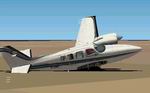
FSX/FS2004 F/A-18E or F Super Hornet VX-23 CAG Salty Dogs textures Only
(Category: FSX > Military)
2.76Mb (2022 downloads)
FSX/FS2004
F/A-18E or F Super Hornet VX-23 CAG Salty Dogs textures Only.
This superhornet squadron is an air test and evaluator unit
on the east coast of the US. They test weapons systems, catapults
on aircraft carriers, etc. Repainted by dmachoe. For use with
Team FS KBT outstanding Model design by Daisuke Yamamoto(
here). 2.8MB
Required files:
required file
Posted Jun 23, 2008 14:17 by archive
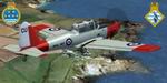
FS2004/FSX De Havilland Chipmunk 771 NAS & HMS Seahawk Station Flight Textures only
(Category: FS2004 > Props)
1.70Mb (2022 downloads)
FS2004/FSX
De Havilland Chipmunk 771 NAS & HMS Seahawk Station Flight
Textures only.
These textures represent DHC Chipmunk WP776 of the HMS Seahawk
(RNAS Culdrose) Station Flight and have been released to celebrate
A) the station's 60th Anniversary (1947-2007); and B) my engagement
nearby at The Lizard! In 1983 WP776 joined 771 NAS, where
it remained until 1992. The inspiration for these textures
was Geoff Wakeham's 2007 book "RNAS Culdrose: 1947-2007"
published by Tempus and highly recommended!Requires the excellent
freeware aircraft by Rick Piper.
Textures are by Andy Ford. 1.7MB
Required files:
required file
Posted Jun 23, 2008 14:25 by archive

FS2004 United Airlines New Colors (United/Continental merger) Boeing 787-8 V2
(Category: FS2004 > Civil Jets)
5.68Mb (2022 downloads)
FS2004 United Airlines New Colors (United/Continental merger) Boeing 787-8 V2. Versions 2 includes aircraft design improvements plus new animations.
This CamSim Version 2 is also includes three aircraft with different Animated Ground Servicing (AGS).
Model design and paint by Camil Valiquette.
Posted May 9, 2010 09:23 by Camil Valiquette
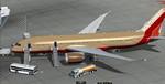
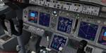
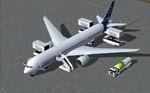
Boeing 787-8 Southwest Airlines Package
(Category: FSX > Civil Jets)
110.78Mb (2021 downloads)
FSX Boeing 787-8 Southwest Airlines N-778SW with VC for FSX
Model by TDS/ Tenkuu Developers Studio
with advanced 737-800 VC added. Includes utility for ground services, Passenger buses, cargo, stairs, refuelling etc (find it under - Views - Instrument panel - Util)
The wonderful new Boeing 787-8 from TDS will be enjoyed by many more people who do not know how to install a VC into a FSX native model. So now the 787-8 has the nearest VC I can find -- the 737-800. The layout fof the 787 cockpit is not a million miles away from the advanced 737-800.
The VC is the Alejandro Rojas Lucena/FSND fantastic revised Boeing 737-800 VC model. This VC model includes Working wipers (right mouse click on switch) with rain effect. Switches for LCD Screens, EICAS, PFD, MFT. Autobrake switch. Opening pilots window. Cabin Lights switch. Realistic FMC. Ground Proximity Warning System (GPWS), More Realistic night VC textures. There are custom Boeing sounds included for that extra realism.
High quality textures by B Minister
Model is not modified in any way. Just the VC added and aircraft.cfg edited to allow correct VC views.
TDS wonderful native FSX Boeing 787-8 model. See VC docs to get the best out of the VC and FMC.
Assembled and prepared for FSX by Chris Evans.
Posted Sep 10, 2013 06:02 by Chris Evans
FS2002
AIRCRAFT DAMAGE Files.
(Category: FS2002 > Misc)
0.22Mb (2021 downloads)
FS2002
AIRCRAFT DAMAGE Files.
CFG & AIR files. This file will add bigger and cooler crash
effects to any aircraft. As always BACK UP YOUR ORIGINALS before
installing these files! By Saad Ahmad. 228K
Posted Jun 23, 2008 14:32 by archive

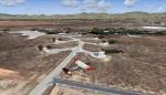
FS2004
Can Tho Army Airfield, Vietnam 1969
(Category: FS2004 > Scenery)
1.15Mb (2021 downloads)
FS2004
Can Tho Army Airfield, Vietnam 1969.
A model of Can Tho Army Airfield as it appeared in 1969 at the
height of the Vietnam War. Can Tho was a major airbase in the
Mekong Delta about 4 miles southeast of Binh Tuy AB and 3 miles
northwest of the city of Cantho. It was the home of the US Army's
13th Aviation Batallion. There airport code for Can Tho Army
Airfield was VVCT. That code is now assigned to Tra Noc airport.
This scenery was designed for FS 2002 but it should work in
FS 2004. George Knowles. 580K
Posted Jun 23, 2008 14:24 by archive
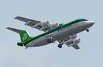
FS2004
BAe146-300 v1.0 Aer Lingus Commuter Textures only
(Category: FS2004 > Civil Jets)
2.18Mb (2021 downloads)
FS2004
BAe146-300 v1.0 Aer Lingus Commuter Textures only
for the brand new FS9 model of the BAe146-300 by Jon Murchison,
this is version 1 with the 100/200 models to follow along with
a VC in later versions. You will need to visit HJG to download
the base model and sound pack along with a new 146 panel for
this model created By Matthias Lieberecht of The BAe Panel Project.
(here)
(see docs for details) Textures by Tony Madge HJG. 2.2MB
Posted Jun 23, 2008 14:29 by archive
Airbus House Colors Airbus A350-800 XWB
(Category: FS2004 > Civil Jets)
6.24Mb (2021 downloads)
FS2004 Airbus House Colors Airbus A350-800 XWB V2. Versions 2 is an all new version with a new nose, new cockpit windows, new wings and winglets.
This CamSim Version 2 is also includes three aircraft with different updated new Animated Ground Servicing (AGS).
Model design and paint by: Camil Valiquette
Posted Nov 13, 2009 09:36 by Camil Valiquette
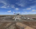
Turkey Konya Airfield
(Category: FSX > Scenery)
51.40Mb (2021 downloads)
Turkey Konya Airfield (LTAN) VFR scenery. A moderately detailed scenery of Konya Airfield mainly done by the Instant Scenery program for FSX (SP2). Contains realistic positioning of objects and autogen, has also some photoreal texture components. By Sunay KILIC.
Posted May 25, 2009 19:29 by Sunay KILIC
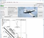
FSX/P3D FS Flight Builder
(Category: FSX > Utilities)
69.58Mb (2020 downloads)
New version: Updated installer and auto-update functionality along with chart downloaded changes to support browser updated security measures. FS Flight Builder is a utility for general aviation flying that will build flight files for FSX (flt), FSX Steam Edition (flt), and Prepar3D (fxml) based on waypoints and other data either entered manually or imported from SkyVector using the Plain Text Link information. Among other things, you can select your starting position, aircraft, and VFR or IFR flight plan. One of the most interesting features of the application is that it will include a Briefing file, added to the aircraft's built-in kneedboard, that will include departure and destination airport information (runways, frequencies, weather, and charts) as well as navigation frequencies along the route. Have you ever started up flight simulator and wondered “where do I want to go today”? The new Destination Chooser functionality can help to solve that problem. The screen allows you to enter your departure airport and choose various parameters for your destination (like min and max distance, tower availability, ILS availability, runway length requirements, etc.). How to install: Run Setup.exe and simply follow the installation wizard. When you run the application for the first time (make sure your flight simulator is not running), it will build the database from your flight sim data. Be patient. It could take a few minutes. It will attempt to locate your flight sim folder and flight plan folders automatically. If it can't find them, however, you'll need to select them from the options menu. IMPORTANT! Because FS Flight Builder saves to your Flight Sim directories, it MUST be run in Administrator mode. To do this, right-click on the desktop icon, select the Compatibility tab, and check the Run as administrator checkbox. IMPORTANT! The airport and navaid databases for FS Flight Builder are built using Peter Dowson's excellent Make Runway utility and the equally excellent BGL2XML utility from ScruffyDuck Software. The links to these utilities are below. They must be added to the main FSX or Prepar3D folder. Peter Dowson's website: http://www.schiratti.com/dowson.html ScruffyDick Software website: http://www.scruffyduck.org/bgl2xml/4584282773 It's also important to note that Version 1.7 of BGL2XML is required for Prepar3D V3 and higher. Author: Tom Arduini The latest installer can always be found at http://www.arduiniwebdevelopment.com/fsflightbuilder/fsflightbuilder.zip
Posted Dec 23, 2018 19:04 by Tom Arduini